The town of Cesky Krumlov is a UNESCO World Heritage site located on the banks of the Vltava River (the Moldau) in the South Bohemian region of the Czech Republic, about 2-1/2 hours south of Prague by car. It was built during the 14th through the 17th centuries, primarily in Renaissance style, with additional gothic and baroque elements. It is situated around a 13th century castle which is the second largest in the Czech Republic (after the Prague castle), comprising a total of 40 buildings. UNESCO characterizes the town as “an outstanding example of a small central European medieval town whose architectural heritage has remained intact thanks to its peaceful evolution over more than five centuries.”
The original gothic castle, around which the town of Cesky Krumlov was built, was founded by the Lords of Krumlov around 1253. In 1302, the castle and town were inherited by the Rosenbergs, an aristocratic family related to the founders. The House of Rosenberg ruled Cesky Krumlov until 1602. During this period, the castle was rebuilt in Renaissance style, and the town experienced its greatest prosperity, with rapid economic development, construction of new buildings, and the expansion of trade with other cities in the region.
In 1602, the Emperor Rudolf II von Habsburg bought the Krumlov dominion. In 1622, it was transferred to the Eggenberg family. In the 1680’s, under the rule of Johann Christian I von Eggenberg, farming, construction, and the arts flourished, helping Cesky Krumlov rise out of a period of stagnation that resulted from the Thirty Years’ War (1618-1648). He also undertook extensive renovations and expansions of the castle in the baroque style.
In 1719, a new dynasty, the Schwarzenbergs, inherited Cesky Krumlov. In the second generation of their rule, Joseph Adam zu Schwarzenberg undertook an extensive modification of the castle in the baroque style.
After World War I, Cesky Krumlov became part of Czechoslovakia. In 1938 it was annexed by Nazi Germany, as part of the Sudetenland according to the Munich agreement. After World War II, the town’s German-speaking population was expelled and it was returned to Czechoslovakia.
During the Communist era of Czechoslovakia, Cesky Krumlov fell into disrepair, but since the Velvet Revolution of 1989 much of the town’s former beauty has been restored. In 1992 it was designated as a UNESCO World Heritage site and it is now a major holiday destination popular with tourists.
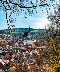
Our hotel in Prague (the Golden Well — highly recommended!) arranged for a one-day tour of Cesky Krumlov with a driver and guide. There was only one other tourist in our group besides my wife and me. Upon our little group’s initial approach to Cesky Krumlov, we caught a glimpse of the town through the trees (you may click on any photo in this article to see a larger version):

The steeple in the center of the photo belongs to the Church of St. Vitus, a gothic structure set in mostly Renaissance surroundings.
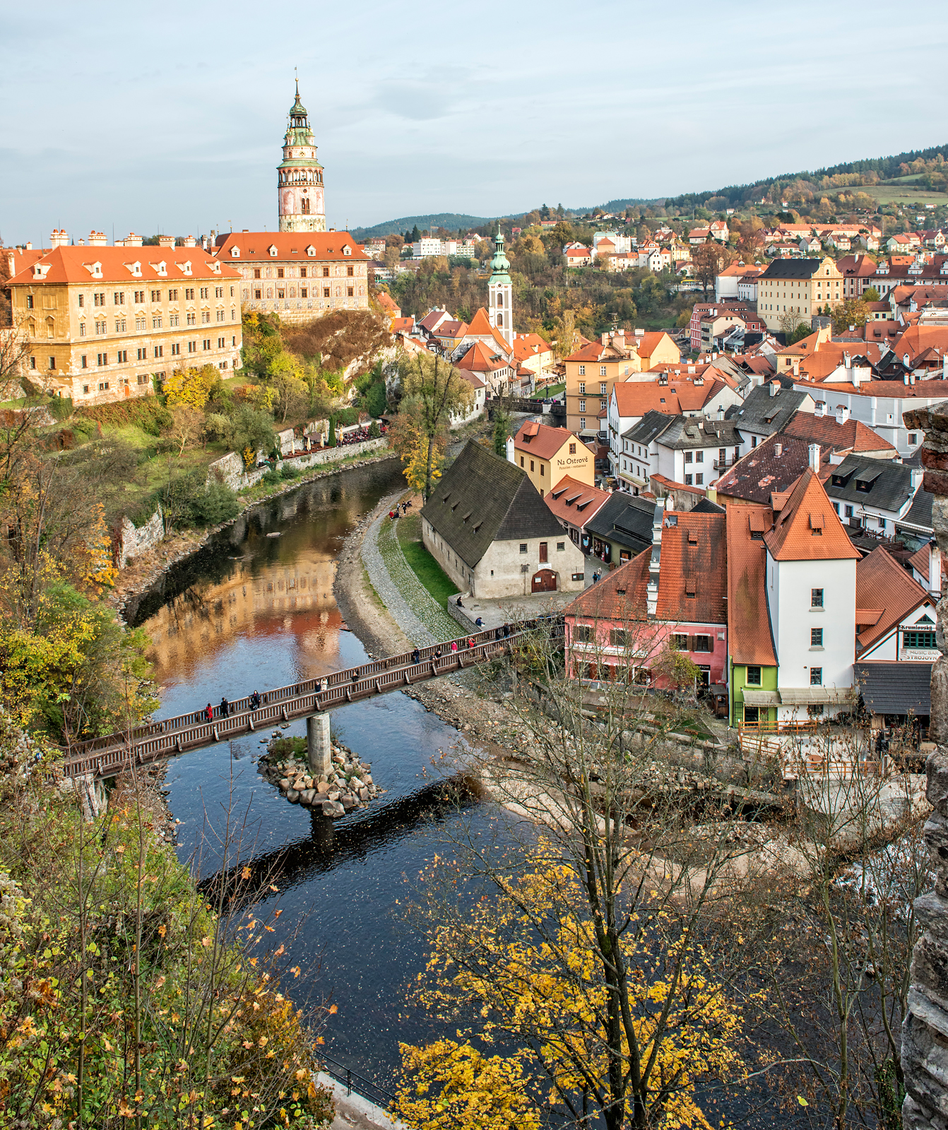
As we approached the castle, we came to a parapet that serves as an ideal lookout site. My wide angle lens served to sweep a large part of the town into a single shot:

As we approached the entrance to the castle, we saw other impressive views of the town:

We proceeded through the castle. Seen below is a portion of an internal courtyard decorated in characteristic Renaissance trompe l’oeil style:

The seemingly three-dimensional stone blocks in the walls in the photo above are actually not stone blocks at all but are painted on a flat surface.
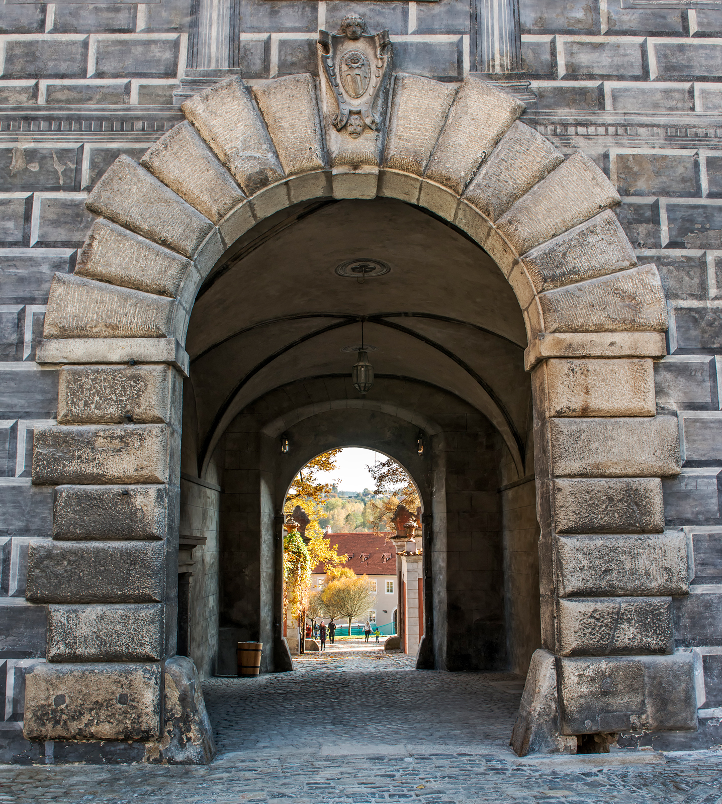
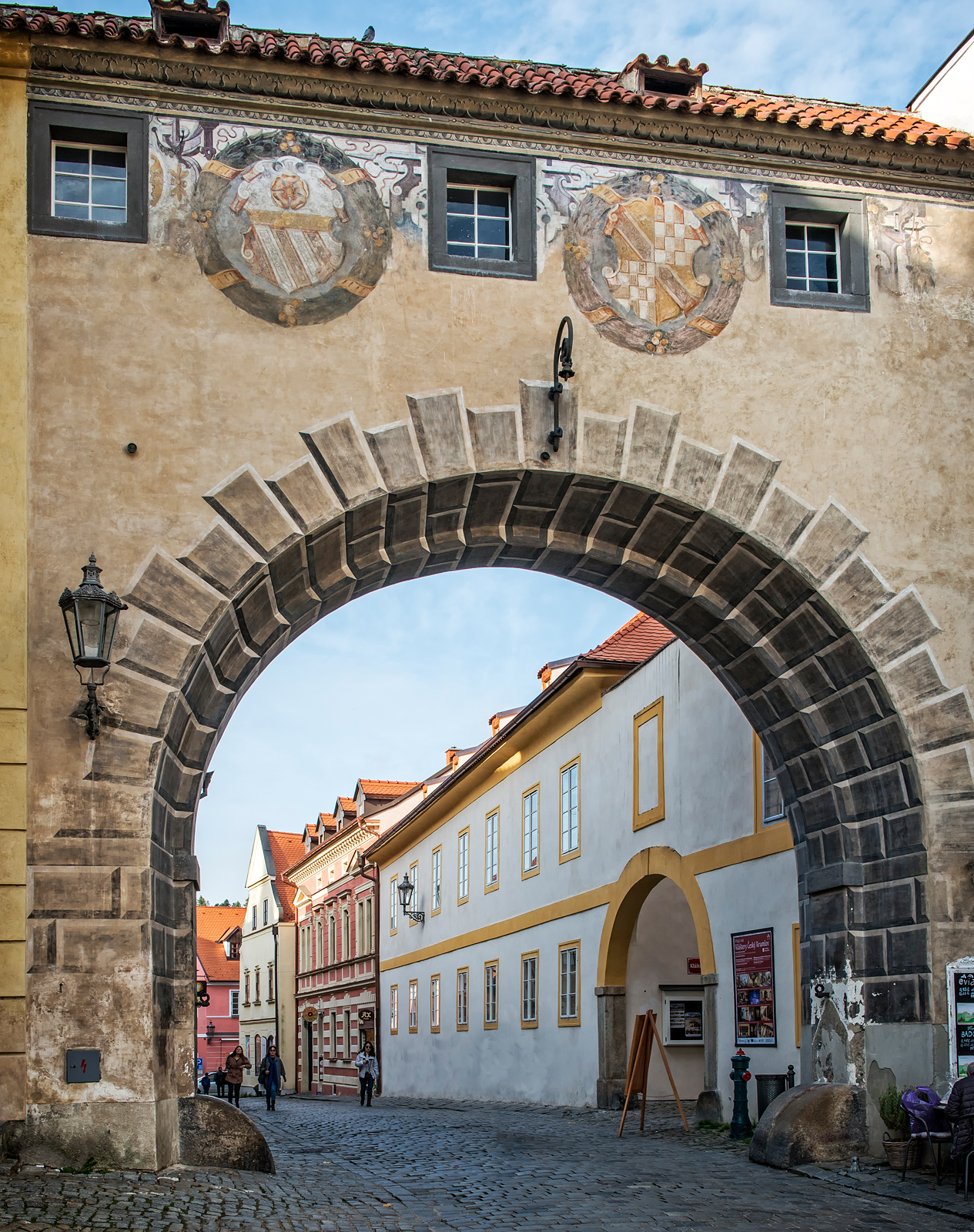
We walked through an arched tunnel that separates two internal courtyards in the castle:
Different parts of the castle are also joined by an enclosed connecting bridge supported by a multi-tiered set of arches:

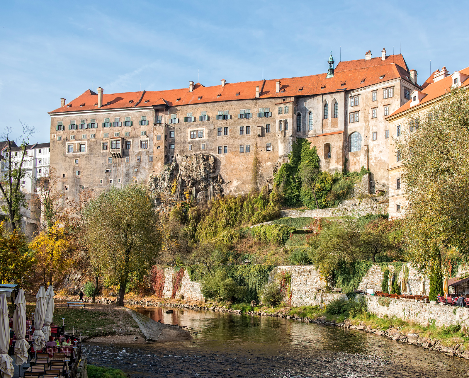
Here is a view of one of the principal buildings of the castle, from a pedestrian bridge over the Vltava River:
Shown in the photo below is the beautiful St. Jost Church:
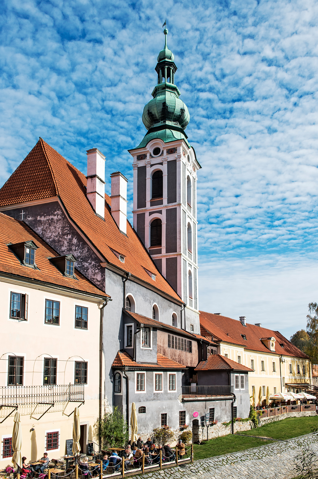
Shown in the next photo is the castle’s lookout tower as viewed from a street in the town. Note the Renaissance style decoration on the tower and the walls of the building below it:

Here is a shot of the castle tower and the St. Jost Church together:

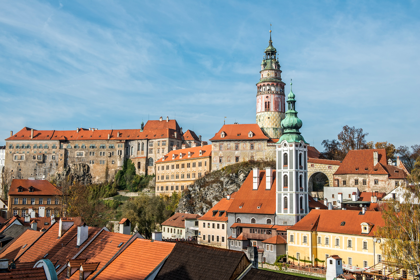
In this photo, a large part of the castle is visible, along with the St. Jost Church and other buildings situated along the banks of the Vltava River:
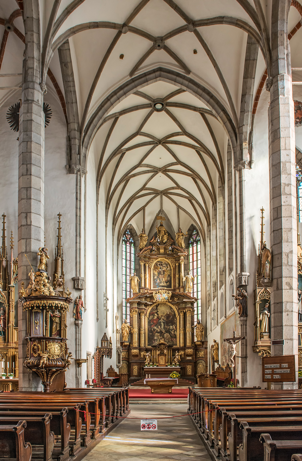
We also visited the gothic St. Vitus Church, of which this is an internal view:
Here are some of the other breathtakingly gorgeous views one sees from the street inside the town:


For visitors to Prague, one-day and two-day group and private tours to Cesky Krumlov are available from a variety of tour companies. The trip is well worth the effort.
The photos shown in this article and other photos of Cesky Krumlov are available for viewing and purchase in full original resolution in the Cesky Krumlov Gallery of my photography website. For further information about my photography, please also visit my photography Facebook page.
Phil Haber
Copyright © 2016 Philip A. Haber
In January of this year, my wife and I spent several days in the beautiful and historic town of Hoi An, Vietnam. Hoi An is located on the east coast of Vietnam in Quang Nam Province, about a half hour’s drive south of Da Nang. The Lonely Planet guide to Vietnam describes Hoi An as Vietnam’s “most atmospheric and delightful town.” Situated at the mouth of the Thu Bon River, where the river flows into the South China Sea, Hoi An was a major trading port from the 16th to the 19th centuries. It was visited regularly by Chinese, Japanese, Dutch, Portuguese, Spanish, Indian, Filipino, Indonesian, Thai, French, British and American traders who came to Hoi An to purchase high-grade silk and many other products, and was the site of a number of Japanese and Chinese settlements in addition to the local Vietnamese community.
Toward the end of the 19th century, the Thu Bon River silted up and Hoi An was replaced by Da Nang as the region’s principal trading center. As a result, Hoi An was largely unaffected by the modernization experienced by Da Nang and other commercial centers and its street patterns and architecture are very much the same today as they were in the 19th century. The town thus displays a profusion of centuries-old wooden Japanese and Chinese structures in addition to the local Vietnamese buildings. This largely accounts for Hoi An’s historic charm. It was designated in 1999 as a UNESCO World Heritage site, for its character as “an exceptionally well-preserved example of a South-East Asian trading port.” See http://whc.unesco.org/en/list/948. Its economy today is heavily oriented toward tourism, and it is a much prized culinary center with a large number of excellent restaurants and cooking schools. Silk and silk fabrics, clothing and lanterns are still, however, the town’s most sought after local products.
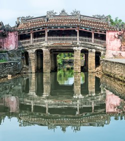
The most famous example of Japanese architecture in Hoi An is the Japanese Covered Bridge. First constructed in the 1590’s, its arched shape was later flattened by the French to make it suitable for automotive traffic. However, it was restored to its original shape in 1986. Inside the bridge, on its north side, is a small temple to Tran Vo Bac De, a god of weather. (Note: You may click on any photo in this article to see a larger version.)

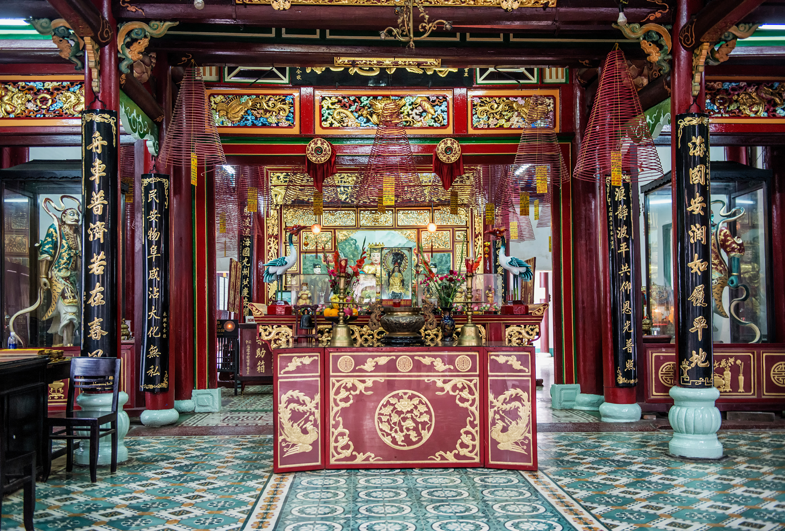
Examples of Chinese architecture abound, including several assembly halls that serve different communities of Chinese immigrants residing in the town. Here we see the entrance gate to the Assembly Hall of the Fujian Chinese Congregation. Originally built as a place for Fujian Chinese immigrants to socialize and trade, this assembly hall was later transformed into a temple to Thien Hau, their goddess of the sea.

Inside the gate is the entrance to the Assembly Hall itself:

Seen here is the altar to the goddess, located inside the Assembly Hall:
The town includes a number of small islands surrounded by arms of the Thu Bon River, to which the main part of the town is connected by several bridges. The islet of An Hoi is connected by, among other bridges, a beautiful pedestrian bridge that is decorated with fanciful sculptures and silk lanterns:

I photographed this beautifully dressed young pedestrian crossing the bridge:

From the pedestrian bridge, there is an excellent view of the Hoi An waterfront:

Crossing the pedestrian bridge to An Hoi island affords another view of the town’s waterfront:
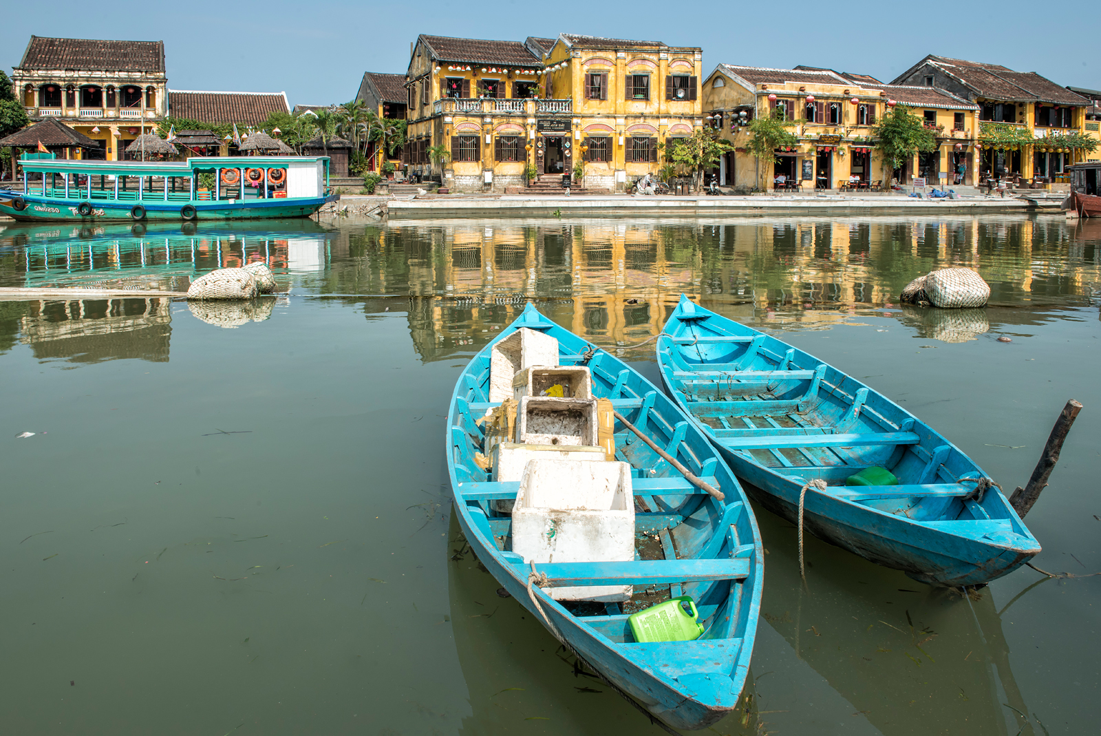
Colorful boats line the waterfront, available to give tourists a scenic ride for a reasonable price:

This elderly gentleman was beckoning to passing tourists in hopes of selling rides on the boat sitting directly behind him:

As previously mentioned, Hoi An is renowned for its beautiful silk and silk products. This fact is celebrated by a giant silk lantern mockup situated on the island of An Hoi at the edge of the river:

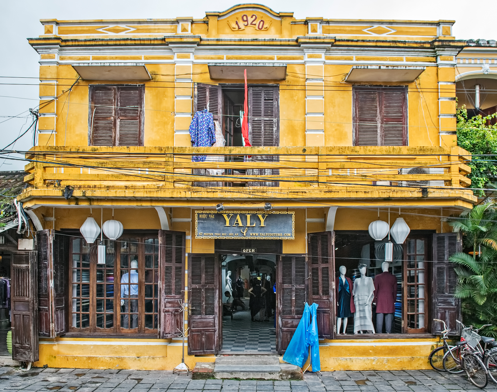
Hoi An is home to several expert tailor shops, such as Yaly Couture, where a visitor can select from a large stock of silk fabrics and have a custom suit, dress or shirt made in a few days.
Many of the streets in Hoi An are decorated with colorful silk lanterns, some strung across the street on overhead wires. These are lit at night to spectacular effect. Here is a view of Nguyen Thai Hoc Street at night, just outside the entrance to the highly-rated restaurant Morning Glory:

The pedestrian bridge is likewise brightly lit at night:
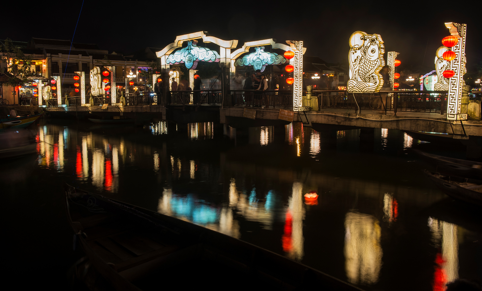
Here is another night view, looking across the Thu Bon River at An Hoi island:
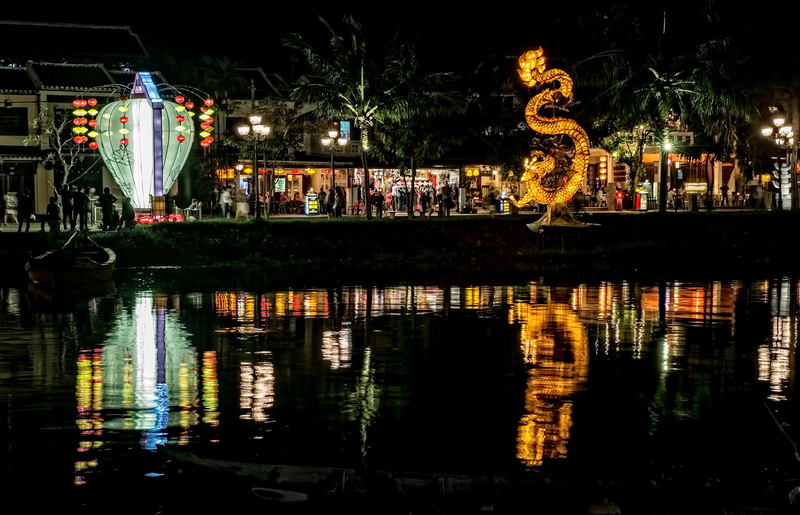
The night market on the island of An Hoi is also worth a visit. There are brilliantly lit lantern shops like this one:

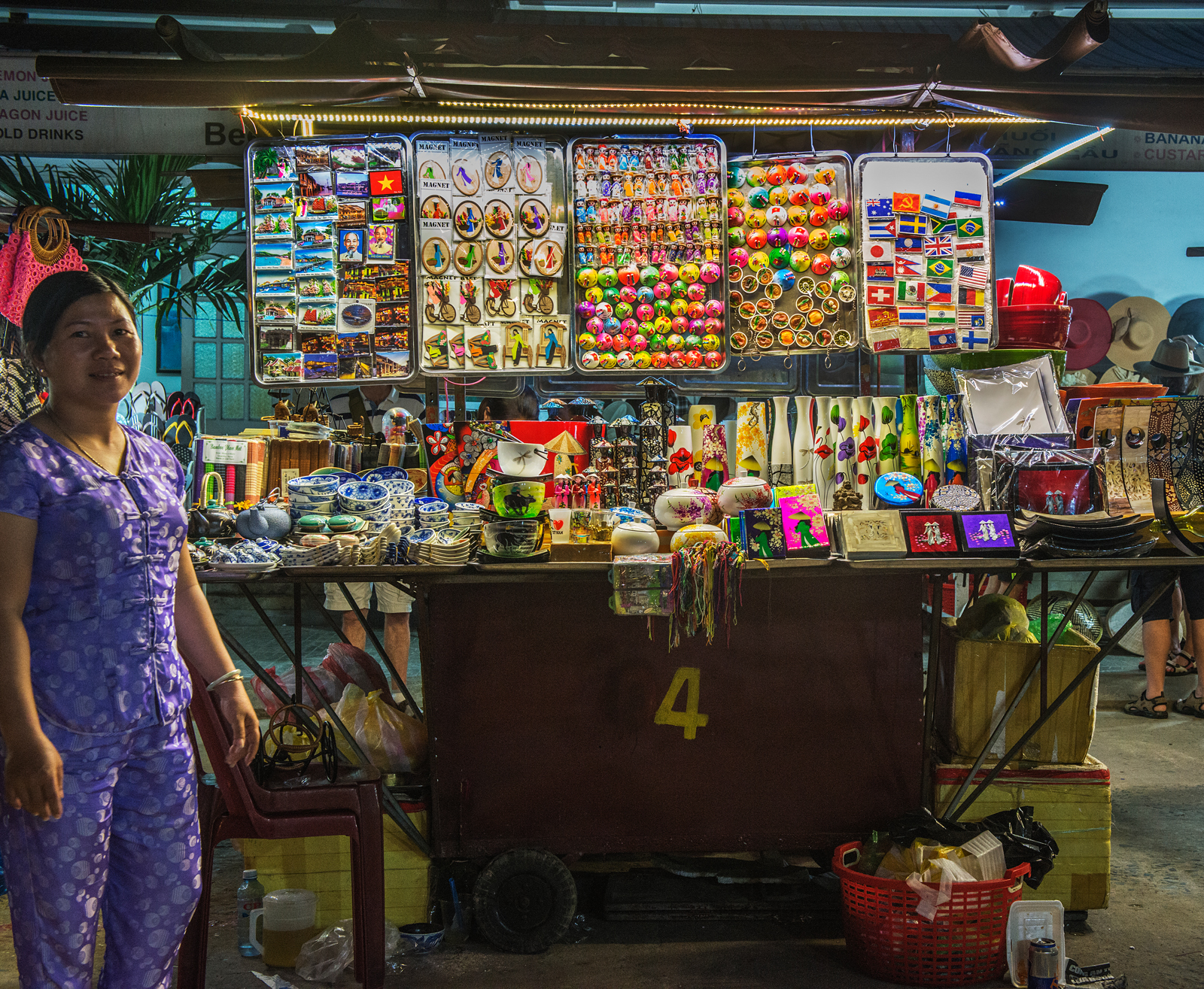
The night market also features several blocks of brightly lit stalls, mostly offering touristy knick-knacks:
Hoi An is also justly celebrated as a culinary center, boasting over 500 restaurants serving a wide variety of Vietnamese, Chinese, Japanese, Thai, Indian, European and American cuisines. Many of these restaurants also offer cooking classes, where visitors to the town can sample a variety of local dishes and learn techniques of preparation. My wife and I took a two-hour cooking class at Vy’s Market Restaurant and Cooking School, a local favorite located across the pedestrian bridge, on An Hoi island. Like many restaurants in the region, the sides of the restaurant are lined with cooking stations each specializing in certain dishes. Here is a view of the inside of the restaurant:

Cooks prepare dishes at each of the stations:

As our little group of “students” made the rounds of the various stations, guided by an English-speaking teacher, we performed some of the steps required in the course of preparation and sampled the results, resulting in a satisfying meal as well.
The days my wife and I spent in Hoi An were one of the principal highlights of our visit to Southeast Asia. Travelers to the region should not miss an opportunity to experience it.
Copyright © 2016 Philip A. Haber

In light of the recent tragic and terrible events in Paris, I have written this blog article as a tribute to the city, illustrated by photos I have taken during several prior visits there. Paris has a very long history, and has survived and prospered despite other tragic events, some more destructive and terrible than those of November 13, 2015. These include the Viking siege of 845 AD, deadly outbreaks of bubonic plague during the 14th and 15th centuries, bombardments and occupation during the Hundred Years War (1338 – 1453), the St. Bartholomew’s Day Massacre of 1572 and other tragedies of the wars of religion between Catholics and Protestants, the events of 1793 and the Reign of Terror, the defeat of France by Prussia and crushing of the Paris Commune in 1870-71, and conquest and occupation by the Nazis in 1940-44. Yet, despite all of these cataclysms and more, Paris has endured as the ultimate “City of Light,” one of the world’s great centers of art, literature, science, education and culture, a beacon of light to all humanity and a monument to many of humanity’s greatest achievements.
We start with Paris’ most famous avenue, the Champs Élysées, here seen at night during Christmas week in full holiday dress. Visible at the far end of the Champs Élysées is the Arc de Triomphe de l’Étoile, erected to honor all those who fought and died for France in the French Revolution and the Napoleonic Wars (click on any image in this blog to see a larger copy):

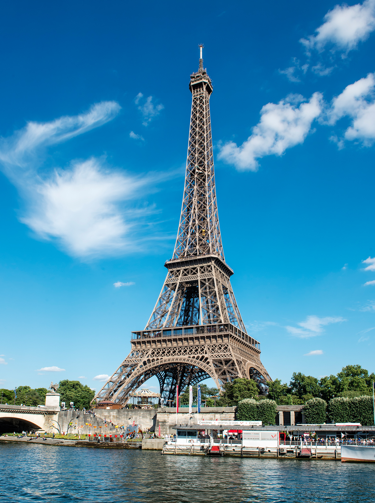
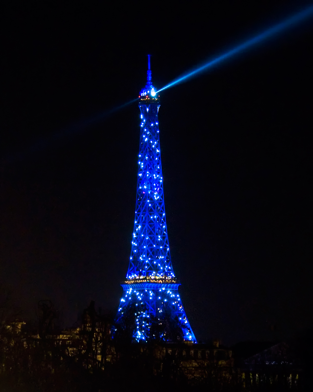
No photo essay on Paris would be complete without a view of the city’s most famous symbol, the Eiffel Tower, built in 1889 as the entrance to the 1889 World’s Fair. Here are two photos, one taken during the day from a boat on the Seine, the other at night in blue light taken during a light show:
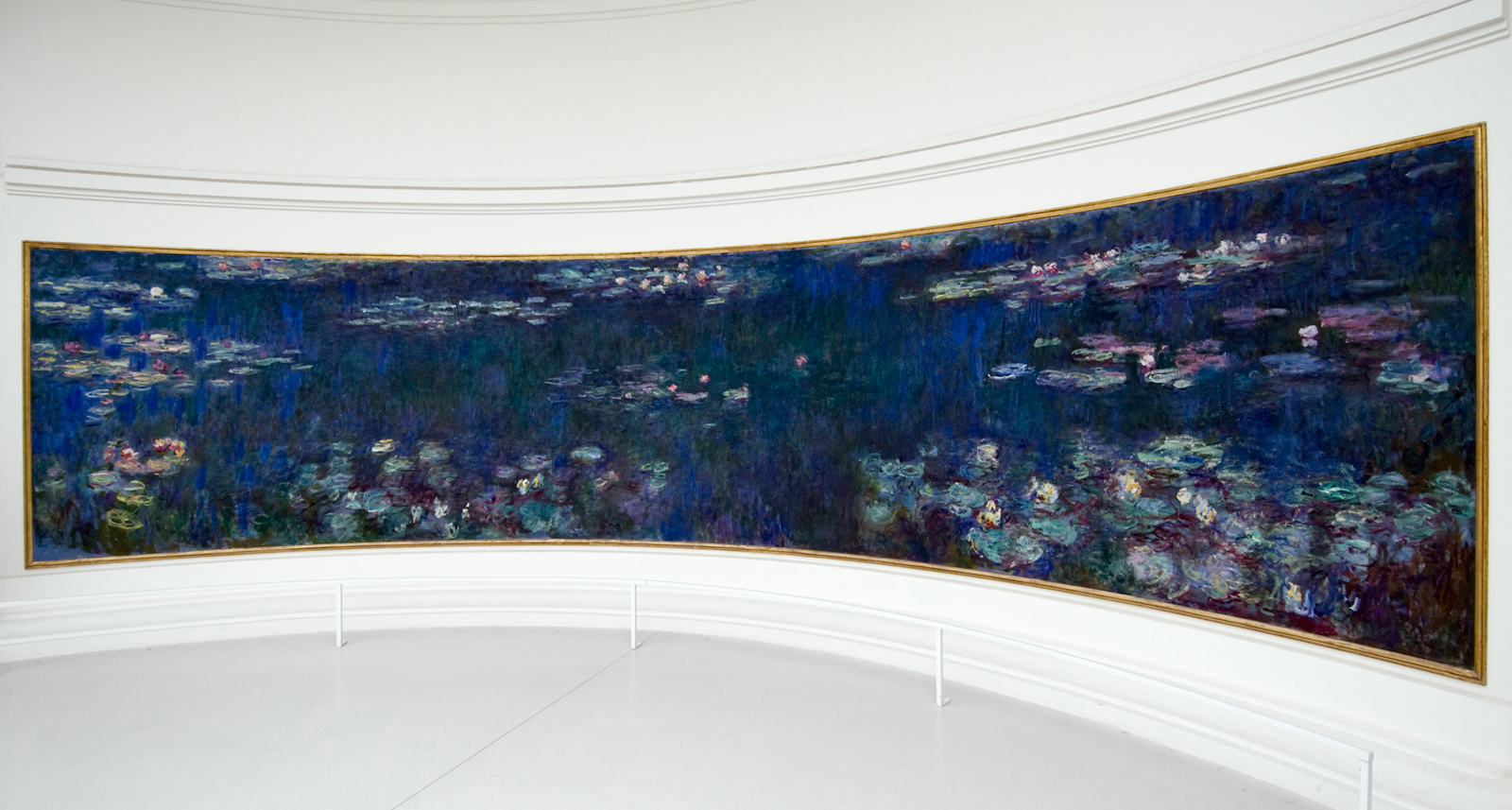
Paris is of course well known for its great museums, particularly art museums. One of my favorites is the Orangerie, located at the western end of the Tuileries adjacent to the Place de la Concorde. The ground floor of the museum contains two large oval rooms, the walls of which are covered with panoramic panels containing paintings of waterlilies by Claude Monet. The ceilings of these rooms have been replaced with glass, in order to honor Monet’s wish that the paintings be seen in natural light. The following is an example of just one of these magnificent panels:
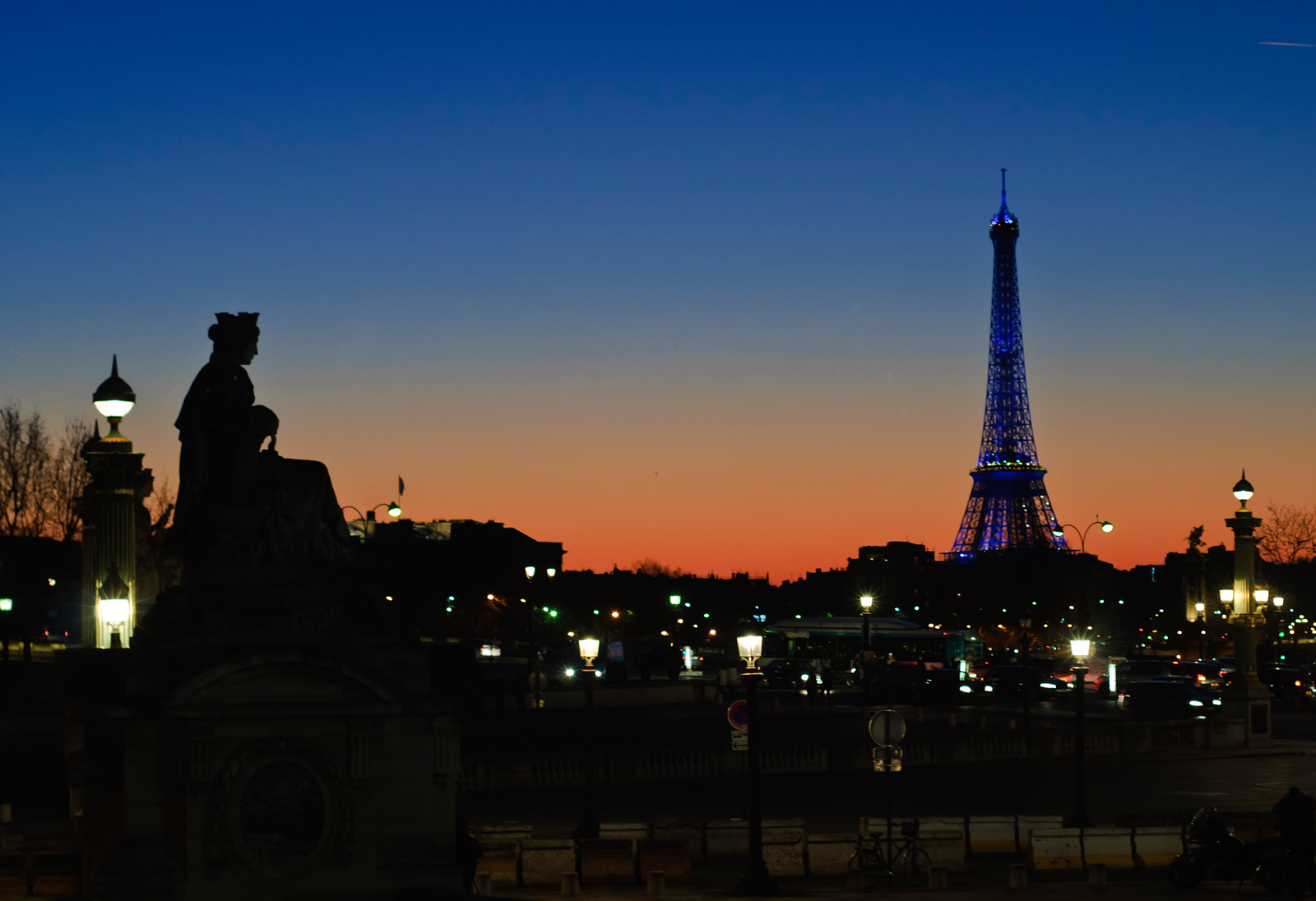
Next to the Orangerie is a wonderful view over the Place de la Concorde, seen in this photo just after sunset:
Here is a view of the Place de la Concorde during the daytime:

Also located in the Place de la Concorde is the Luxor Obelisk. Originally located at the entrance to the Luxor Temple in Egypt, the obelisk was a gift to France from the Khedive of Egypt and was set up in the Place de la Concorde in 1836. It is approximately 75 feet high, is decorated with hieroglyphs exalting the reign of the pharaoh Ramses II and is topped with a gold pyramid cap added in 1998.

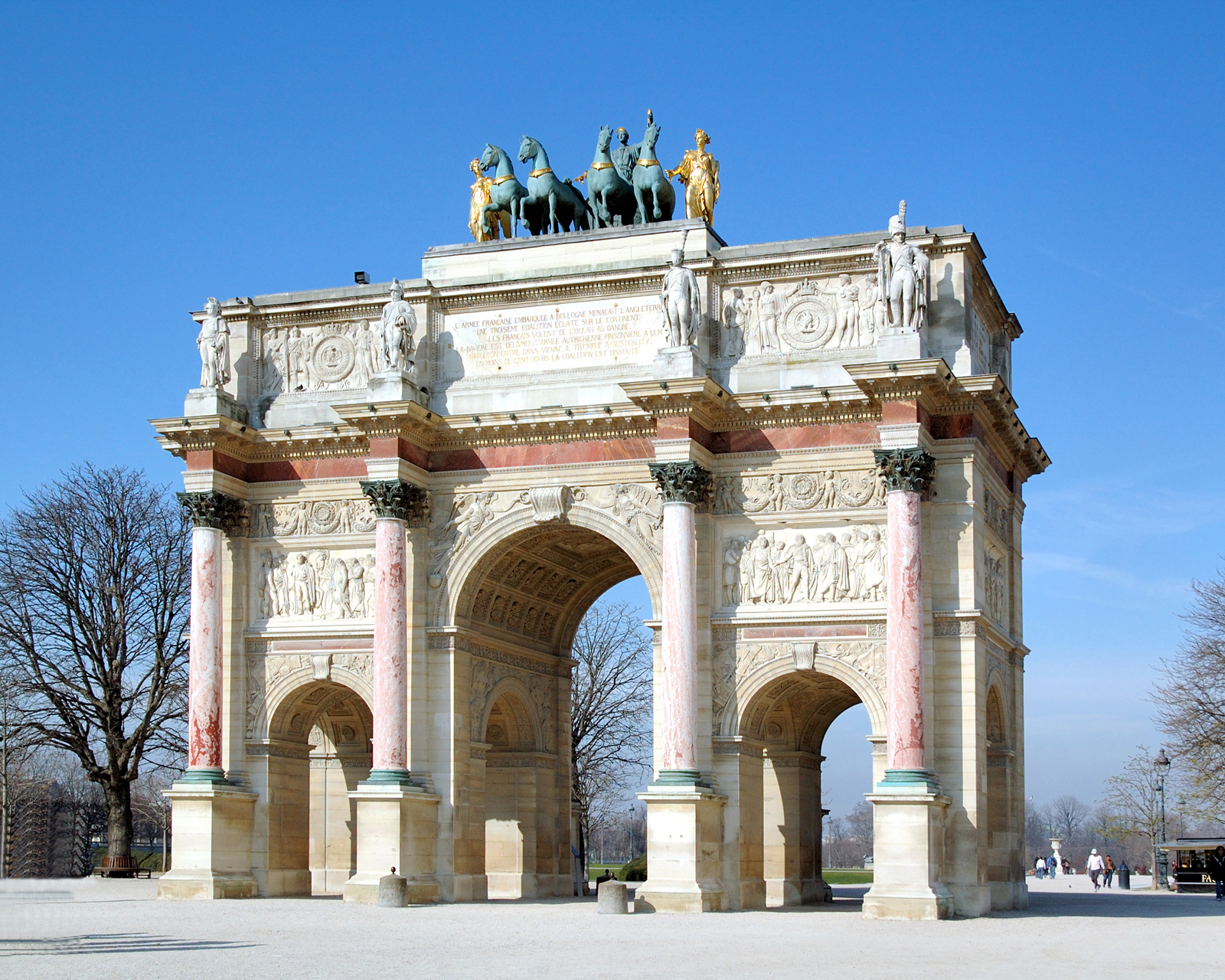
Another major Paris sight is the Arc de Triomphe du Carrousel. Located at the eastern entrance to the Tuileries, the arch was built between 1806 and 1808 to celebrate Napoleon’s victory at the Battle of Austerlitz in 1805 and other military victories won that year.
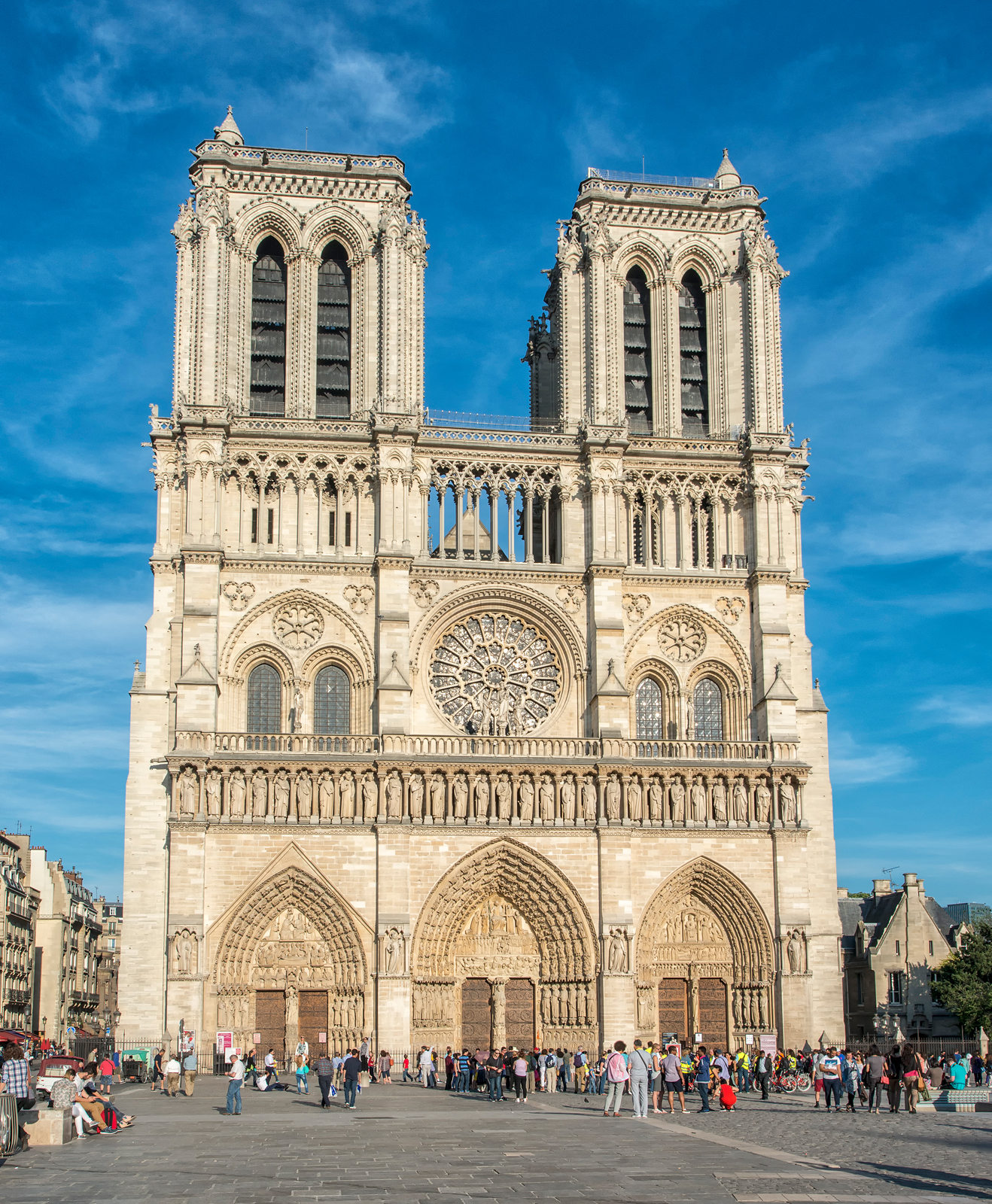
Another famous Paris sight is of course the Cathedral of Notre Dame, built in the Gothic style during the 12th century. The cathedral sits on the eastern half of the Île de la Cité, an island in the river Seine which is the oldest part of the city. The cathedral is also the principal location of Victor Hugo’s great novel Notre Dame de Paris (translated into English as The Hunchback of Notre Dame). Here is a photo of the great western façade of the cathedral, as seen from the parvis, or square, that spreads out in front of the façade:
Here is a photo of the eastern side of the cathedral, as seen from a boat on the Seine, showing the spire and the flying buttresses. Notre Dame was one of the first cathedrals to use flying buttresses to support the walls:

Another must see area of Paris is the Place des Vosges, located in the area of the city known as the Marais. Originally known as the Place Royale, the Place des Vosges was constructed from 1606 to 1612, during the reign of King Henry IV, who however was assassinated in 1610 and thus did not live to see its completion. Its past residents include such famous names as Cardinal Richelieu and Victor Hugo.

Here is a view of the Institut de France, located on the left bank of the Seine across from the Louvre. The Institut houses numerous academies, or learned societies in the sciences and humanities, the most famous of which is the Académie française. The Académie française was created by Cardinal Richelieu in 1635, during the reign of King Louis XIII, and tasked with the creation of a standard version of the French language in order to help in unifying the country. At the time, France was home to literally hundreds of dialects many of which differed to such an extent that residents of one part of France could not understand the language spoken in many other parts of the country.

Visitors to Paris should not miss an opportunity to see the city from one of the tourist boats on the Seine, such as the Bateaux Mouches, that ply the river from dawn to dusk. Here is one seen from the Pont Neuf, at the western end of the Île de la Cité, in the light of a late afternoon sun:

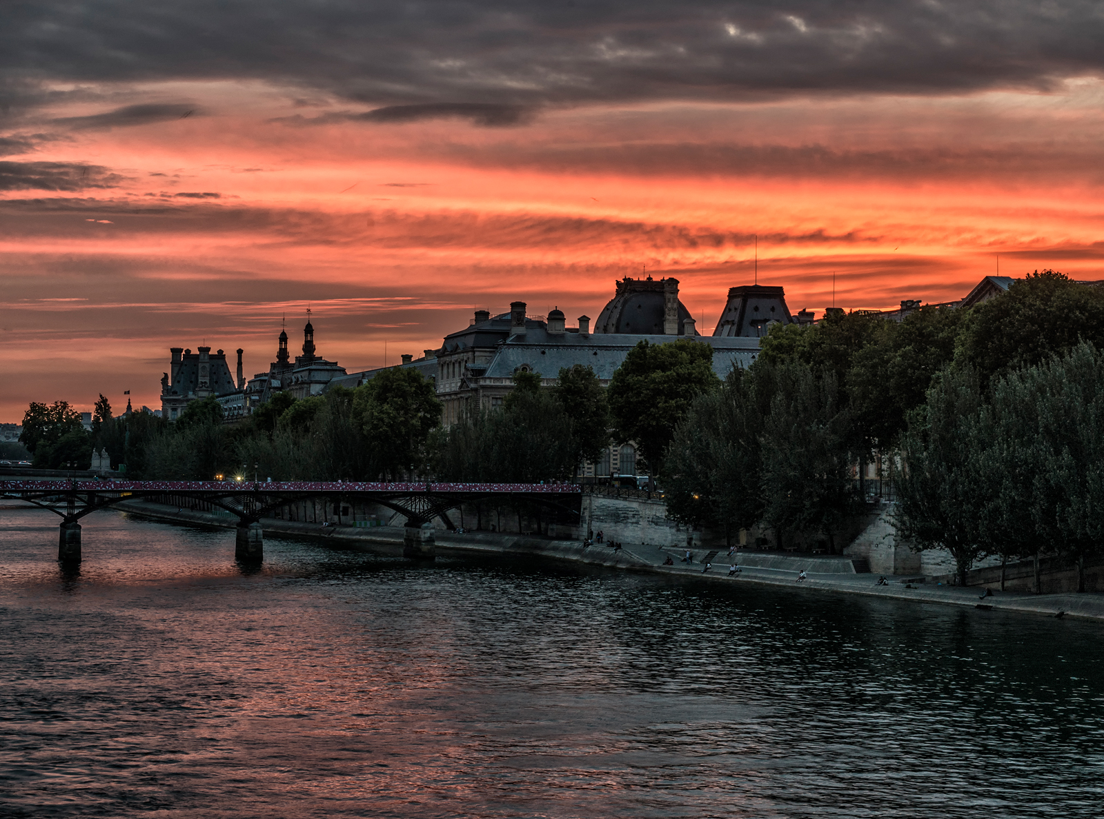
Here is a view to the west from the Pont Neuf at sunset, showing the Pont des Arts, the Louvre and surrounding buildings. Originally the principal palace of the kings of France, the Louvre was opened to the public after the French Revolution and converted into one of the greatest art museums of the world:
I had long wanted to photograph Paris at night and had an opportunity a few years ago to do so during the week between Christmas and New Year’s Day. Some of these photos are shown above, and here are some additional examples:
The Rue de Castiglione:

The Place Vendôme:

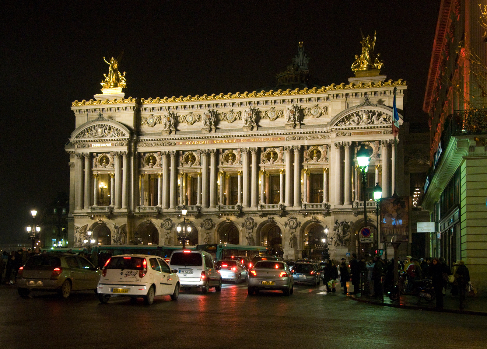
The Opéra Garnier, located at the northern end of the Rue de l’Opéra, built from 1861 to 1875 to house the Paris Opera:
The Galeries Lafayette department store, located on the Boulevard Haussmann:

The above photos are merely a small sample of the wonders to be seen and experienced in this magnificent city, which has endured and prospered for hundreds of years and will endure and continue to display its wonders for the benefit of all humanity long after those who would attack it have disappeared from the face of the earth.
For other photos of Paris and of other beautiful and interesting parts of France, please visit my photo website at http://www.philhaberphotography.com.
Phil Haber
Copyright © 2015 Phil Haber Photography
(Note: An English version of this post may be found at: https://philhaber.com/2011/11/27/in-the-footsteps-of-cezanne-part-iii-the-bibemus-quarries/.)
Un des tours des sites Cézanne offerts par l’Office de Tourisme d’Aix-en-Provence en 2011 comprenait une visite aux carrières de Bibémus, un site où Cézanne travaillait fréquemment de 1895 à 1904. Les carrières sont situées environ six kilomètres à l’est du centre d’Aix. Ces carrières avaient été en service depuis le temps de l’empire Romain, et on les avaient utilisées considérablement pendant les 17ème et 18ème siècles. Les roches d’ochre rougeâtre et jaune qu’on y obtenait étaient utilisées dans la construction de bâtiments et monuments dans Aix et ailleurs. Mais après le 18ème siècle, l’usage des carrières tombait en raison des fissures et des poches de sable qui souvent se trouvaient dans ces roches. Vraisemblablement ces fissures et poches de sable étaient le résultat de la présence d’une haute quantité de sel dans les roches, et par conséquence aussi on ne pouvait pas utiliser le sable qu’on extrait des carrières dans la fabrication de béton. En 1885, les carrières étaient fermées et après étaient complètement abandonnées, et par conséquence Cézanne pouvait y travailler à sa volonté. En 1954, l’artiste américain George Bunker a acheté une partie des carrières. À sa mort en 1991, il l’a léguée à la ville d’Aix-en-Provence à la condition qu’elle soit maintenue comme parc public dédié à la mémoire de Cézanne et qu’elle ne serait jamais développée en entreprise commerciale. En 2006, lors du centenaire de la mort de Cézanne, la ville a ouvert les carrières au public, au même temps que les autres sites des tours sur la vie et l’oeuvre de Cézanne donnés par l’Office de Tourisme.
Lorsqu’il peignait dans les carrières, Cézanne louait un cabanon de pierre qui s’y trouvait pour éviter la nécessité de se déplacer chaque journée entre les carrières et Aix avec ses pinceaux, ses couleurs et d’autres articles. Le cabanon y reste toujours (vous pouvez cliquer sur n’importe quelle image dans ce blog pour en voir une copie plus grande):

Le cabanon de Cézanne aux carrières Bibémus
Les carrières étaient un sujet idéal pour le style de peinture de Cézanne en se prêtant naturellement à la représentation comme collection de formes géométriques de couleurs variées. Voici des exemples:

Carrière Bibémus, 1895, huile sur toile

Coin de carrière, 1900-02, huile sur toile
Bien que beaucoup de végétation a poussée dans les carrières pendant la période de plus de 100 ans depuis que Cézanne y a peint, aujourd’hui on peut voir encore une grande partie de ce paysage exceptionnel:
Rochers aux carrières Bibémus
De temps en temps pendant le tour des carrières, on peut voir des panneaux qui montrent des reproductions de tableaux des carrières peints par Cézanne, chacun placé au site où Cézanne a peint le tableau y reproduit. Ainsi on peut comparer le tableau soi-même, par exemple:

Bibémus: Le Rocher Rouge, c. 1897, huile sur toile
avec une vue du même lieu comme il apparaît maintenant:

Bibémus: Le Rocher Rouge
Dans un des tableaux les mieux connus de Cézanne, on voit le Mont Sainte-Victoire, vu apparemment depuis les carrières de Bibémus, avec des rochers rouges et jaunes des carrières directement en avant et en dessous de la montagne:

Mont Sainte-Victoire vu des Carrières de Bibémus, c. 1897, huile sur toile
Mais c’est intéressant qu’on ne peut pas trouver une telle vue dans les carrières. Bien qu’il y a des vues du Mont Sainte-Victoire depuis quelques sites dans les carrières, de tels rochers n’apparaissent point dans ces vues-là. Par exemple, j’ai vu la montagne pendant le tour des carrières comme ça:
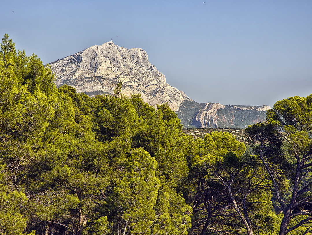
Vue du Mont Sainte-Victoire depuis les carrières Bibémus
Selon notre guide, la scène peinte par Cézanne n’a jamais existée en réalité telle qu’elle apparaît dans le tableau. Cézanne l’avait simplement créée en combinant une représentation de la montagne telle qu’elle apparaissait dans une partie des carrières avec une représentation de rochers qu’on ne pouvait voir que dans une autre partie des carrières. Naturellement, comme peintre, Cézanne pouvait prendre de telles libertés. Une pareille scène semblerait peut-être difficile à produire pour un photographe. Cependant avec la photographie numérique d’aujourd’hui et des outils graphiques comme Photoshop, on peut facilement assembler une telle combinaison photographique:

Le Mont Sainte-Victoire “vu” depuis les carrières Bibémus
Cette photo est composée de parties de deux photos ci-dessus, c’est-à-dire de celle qui s’appelle “Rochers aux carrières Bibémus” et de celle qui s’appelle “Vue du Mont Sainte-Victoire depuis les carrières Bibémus.” Parce que cette photo est très semblable au tableau de Cézanne de 1897 ci-dessus, on pourrait conclure que ce tableau est en effet une combinaison de deux scènes qui n’existent qu’en différentes parties des carrières.
Pour voir des photos supplémentaires d’Aix-en-Provence et photos d’autres villes et villages de Provence et la Côte d’Azur, veuillez visiter la galerie Provence-Côte d’Azur de mon site de Web photographique. Pour obtenir plus d’informations sur ma photographie, vous pouvez visiter aussi ma page photographique de Facebook.
Phil Haber
Copyright © 2015 Philip A. Haber
(Note: An English version of this post may be found at: https://philhaber.com/2011/11/20/in-the-footsteps-of-cezanne-part-ii-the-studio-at-les-lauves-and-mont-sainte-victoire/.)
Après la vente en 1899 de la maison du Jas de Bouffan, qui avait été la propriété principale de la famille Cézanne, l’artiste Paul Cézanne avait besoin d’un nouveau atelier dans lequel il pouvait travailler et garder ses toiles inachevées, ses couleurs et d’autres matériaux. En 1901, il a acheté un terrain dans Les Lauves, une région qui pendant la vie de Cézanne était située dans la campagne au nord d’Aix-en-Provence mais qui aujourd’hui est un faubourg aggloméré à la ville. Ici Cézanne a fait construire son dernier atelier, qu’il a conçu et mis sur pied avec grand soin. Le bâtiment comprend une habitation au rez-de-chaussée et, au premier étage, un atelier avec un très haut plafond, une grande fenêtre qui donne sur le nord pour admettre de la bonne lumière, et une autre fenêtre qui donne sur la ville au sud. L’atelier est situé sur une route qui pendant la vie de Cézanne s’appellait le Chemin des Lauves mais maintenant est nommée simplement l’Avenue Paul Cézanne. Cézanne y a travaillé de 1902 jusqu’à sa mort en 1906 en créant ses derniers chefs-d’oeuvre, y compris Les Grandes Baigneuses, les autres oeuvres de la série des baigneuses, beaucoup de natures mortes, et beaucoup de tableaux du Mont Sainte-Victoire (bien que d’habitude il peignait ceux-ci en plein air). Aujourd’hui il n’y a plus de tableaux dans l’atelier, mais on peut y trouver beaucoup de choses familières, y compris un très grand chevalet, une échelle, des pinceaux et palettes, et divers objets qu’on peut voir dans certaines natures mortes de Cézanne: une table, divers pots, pichets et bols, trois crânes, et un cupidon en plâtre. Malheureusement, il est interdit de prendre des photos dans l’atelier.
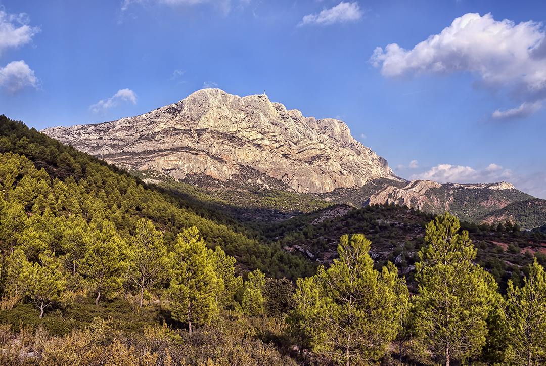
Quand l’atelier était construit, le Mont Sainte-Victoire y était visible. Mais aujourd’hui des bâtiments qui ont été construit tout près de l’atelier et des arbres et d’autre végétation qui ont poussé dans les environs ont bloqué la vue de la montagne. En tout cas, Cézanne a préféré la vue du mont depuis un site qui se trouvait environ un kilomêtre au nord de l’atelier. Ce site, où Cézanne a peint ses derniers tableaux du mont, existe toujours. La ville d’Aix-en-Provence y a fait un petit parc qui s’appelle le “Terrain des Peintres,” situé plusieurs dizaines de pas au-dessus de la route, auquel on peut arriver en montant des marches de pierre. Autour d’une petite place se trouvent dix panneaux qui contiennent des copies de tableaux du Mont Sainte-Victoire que Cézanne y a peints. La vue de la montagne depuis ce site est spectaculaire — voici une photo que j’y en ai prise (vous pouvez cliquer sur n’importe quelle image dans ce blog pour en voir une copie plus grande):

Mont Sainte-Victoire vu depuis le Terrain des Peintres
La photo ci-dessus montre la vue de la montagne qu’on peut voir dans beaucoup de tableaux que Cézanne a peint à ce site, par exemple:

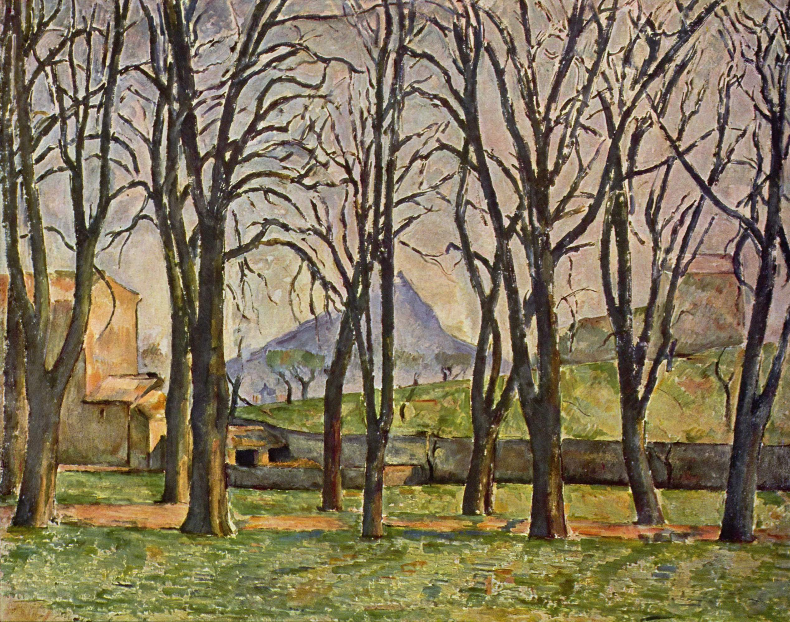
Mont Sainte-Victoire, 1902-04, huile sur toile

Mont Sainte-Victoire vu des Lauves, 1904-06, huile sur toile
Ces tableaux “postimpressionistes” montrent les charactéristiques de l’oeuvre mûr de Cézanne qui ont tellement inspiré les Cubistes, les Fauves et d’autres maîtres de l’art moderne au debut du 20ème siècle: les objets, y compris la montagne, les arbres, les bâtiments et même le ciel et les nuages sont représentés par des “formes-couleurs”: formes géométriques de couleurs variées. L’illusion de profondeur se manifeste par l’utilisation soigneuse de lignes et de taches de couleur qui se contrastent. À noter aussi — la perspective verticale dans ces deux tableaux, et en particulier dans le premier, n’est pas naturelle. L’artiste l’a alterée pour accentuer les formes et les characteristiques de la montagne et de l’espace en avant. On peut voir de telles déformations de la perspective dans les natures mortes de Cézanne aussi bien que dans ses paysages — voir le commentaire d’introduction du grand historien d’art Meyer Shapiro dans son livre Cézanne (Harry N. Abrams, Inc., New York, 1952).
Comme j’ai écrit dans la première partie de cette série d’articles, pendant sa vie Cézanne a peint ni plus ni moins de 87 tableaux du Mont Sainte-Victoire. Alors que, pendant les dernières années de sa vie, Cézanne a préféré le site à Les Lauves, plus tôt il avait peint des tableaux du mont à beaucoup d’autres sites. Un de ses points de vue préférés était près du village de Le Tholonet, qui est situé environ six kilomêtres à l’est d’Aix-en-Provence, sur une route qui s’appellait la Route du Tholonet du temps de Cézanne mais qui maintenant s’appelle la Route de Cézanne. Dans cette région, il y a des merveilleuses vues de la montagne du sud-ouest, qui sont assez différentes de la vue de l’ouest depuis Les Lauves. Voici un tableau du Mont Sainte-Victoire peint par Cézanne à un site près de Le Tholonet:

Mont Sainte-Victoire sur la Route du Tholonet, c. 1900, huile sur toile
À la recherche d’un point de vue pareil, j’ai pris la Route de Cézanne d’Aix à l’est vers Le Tholonet et, après que j’ai passé Le Tholonet, je suis arrivé à un parc situé au côté nord de la route, duquel on pouvait monter sur une colline par un sentier raide pour arriver au point de vue de cette photo-ci:
Mont Sainte-Victoire vue depuis un site près de Le Tholonet
Bien que les citoyens d’Aix-en-Provence n’ont pas accueilli les oeuvres de Cézanne pendant sa vie, aujourd’hui on ne peut pas se déplacer dans Aix sans rencontrer des statues, des plaques, des noms de rues et d’autres choses commémoratives de sa vie et de son oeuvre, par exemple:
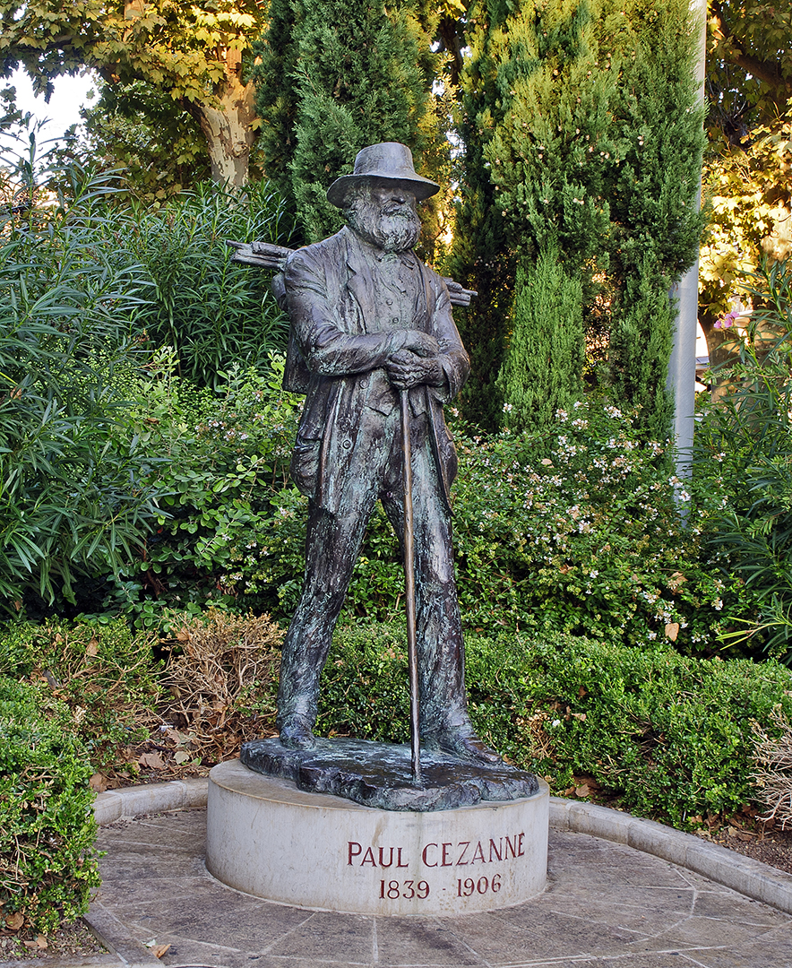
Statue de Cézanne à La Rotonde, Aix-en-Provence
En effet, la personne de Paul Cézanne semble dominer la ville d’Aix-en-Provence de l’Office de Tourisme jusqu’aux limites de la ville. Mais ce n’est qu’un seul aspect d’une ville qui présente au visiteur une quantité énorme de choses merveilleuses.
Pour voir des photos supplémentaires d’Aix-en-Provence et photos d’autres villes et villages de Provence et la Côte d’Azur, veuillez visiter la galerie Provence-Côte d’Azur de mon site de Web photographique. Pour obtenir plus d’informations sur ma photographie, vous pouvez visiter aussi ma page photographique de Facebook.
Phil Haber
Copyright © 2015 Philip A. Haber
(Note: An English version of this post may be found at https://philhaber.com/2011/11/10/in-the-footsteps-of-cezanne-part-i-the-jas-de-bouffan/)
En octobre 2011 j’ai passé plusieurs semaines à la belle et fascinante ville d’Aix-en-Provence. Aix est la ville natale de Paul Cézanne (1839 – 1906), qui y a habité pendant la plupart de sa vie. Un des plus grands artistes du 19ème siècle, Cézanne était selon beaucoup le père de l’art moderne (Picasso et Matisse ont dit tous les deux que Cézanne était “notre père à tous”). Une visite à l’Office de Tourisme d’Aix révèle clairement les liens entre l’artiste et la ville. L’Office de Tourisme offrait trois tours (appelés “Dans les Pas de Cézanne”) des sites dans Aix et ses environs où Cézanne a habité et travaillé. L’Office a produit aussi une carte d’Aix et de ses environs, qui montre où on peut trouver des églises, cafés, maisons et d’autres sites liés aux vies de Cézanne et des autres membres de sa famille.
Un des tours offerts par l’Office de Tourisme comprenait une visite à la résidence principale de la famille Cézanne dans le faubourg d’Aix appelé “Le Jas de Bouffan,” qui était situé pendant le 19ème siècle dans les environs à l’ouest de la ville, mais qui aujourd’hui est incorporé dans la ville agrandie. Contrairement aux situations de beaucoup d’autres artistes au temps de sa vie, Cézanne était le rejeton d’une famille assez riche. Le père Cézanne était commerçant et banquier, et bien qu’il était déçu que son fils voulait faire carrière dans l’art au lieu d’achever ses études de droit, il a subvenu à ses besoins. Cézanne avait 20 ans en 1859 quand son père a acheté la maison du Jas de Bouffan. La maison avait un grand salon au rez-de-chaussée avec un mur courbe et un plafond haut. Cézanne a commencé à peindre dans ce salon en l’an 1860, et en a couvert les murs avec les premiers produits de son art (aspect comique: il a signé “INGRES” sur chaque panneau des murs). Après sa mort, ces tableaux étaient enlevés et transférés aux toiles. Mais le tour de la maison incluait une représentation à son et lumière dans laquelle on projetait des images de ces tableaux à leurs sites originales aux murs.
Conformément au conseil de son copain d’école Émile Zola, Cézanne a déménagé à Paris en 1861, où plus tard sa peinture était influencée par le maître Impressioniste Camille Pissarro. À partir de 1870, Cézanne s’est déplacé fréquemment entre Paris et Provence, y compris à L’Estaque, un village de pêche situé à la côte de la Méditerranée près de Marseille. Mais au début des années quatre-vingt, son père a fait construire un atelier pour lui dans un étage supérieur de la maison du Jas de Bouffan. Après cela, Cézanne a passé plus de temps à Provence, ou au Jas de Bouffan ou à L’Estaque et d’autres sites près d’Aix. Le père de Cézanne est mort en 1886, et Cézanne a hérité alors une fortune substantielle, y compris la maison et les terres du Jas de Bouffan (conjointement avec ses soeurs et beau-frères). Cézanne habitait et travaillait au Jas de Bouffan de temps en temps de cette année jusqu’à 1899, quand il l’a vendu après la mort de sa mère. Beaucoup plus tard, on a vendu la maison et une partie des terres à la ville d’Aix. Depuis 2006, la maison est ouvert au public pour les tours y donnés par l’Office de Tourisme.
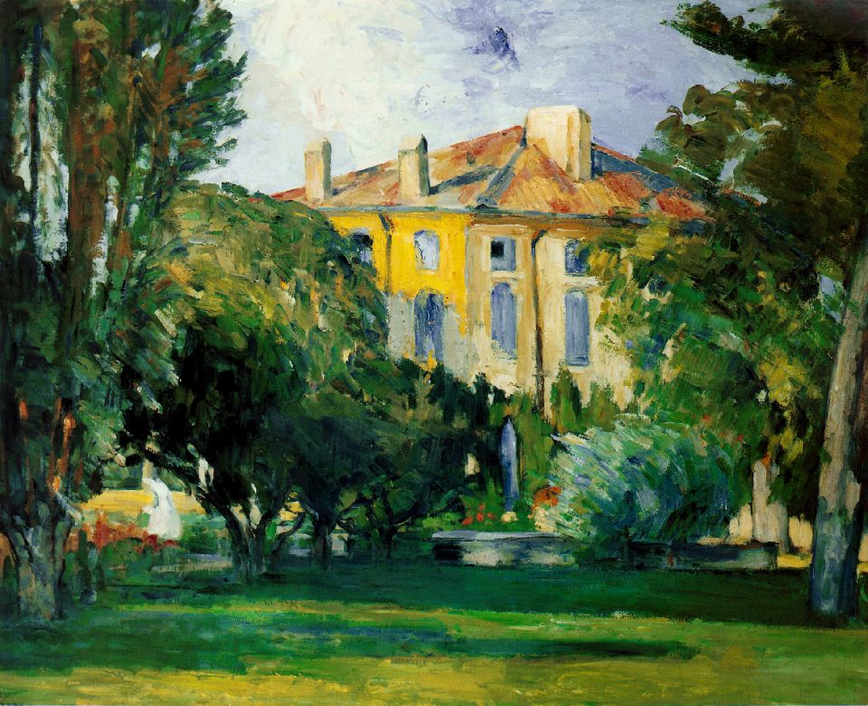
La maison du Jas de Bouffan est située sur des terres assez grandes où se trouve aussi un grand bassin. Pendant sa vie, Cézanne a peint beaucoup de tableaux de la maison et ses terres. La photo ci-dessous, que j’ai prise pendant le tour de la maison, la montre comme elle apparaît aujourd’hui depuis les jardins à l’arrière (vous pouvez cliquer sur n’importe quelle image dans ce blog pour en voir une copie plus grande):

La Maison du Jas de Bouffan
On peut voir cette photo-ci maintenant au nouveau Centre d’Art de l’Hôtel de Caumont, à Aix-en-Provence, dans une exposition sur la vie de Cézanne.
Voici deux tableaux de la maison (vue aussi depuis l’arrière) peints par Cézanne:
La Maison du Jas de Bouffan, 1876-78, huile sur toile
Maison à Toit Rouge (Jas de Bouffan), 1887-90, huile sur toile
Le premier de ces deux tableaux est un bon exemple de la déformation de la perspective qu’on voit dans beaucoup des tableaux de Cézanne. Bien que le point de vue de la maison dans ce tableau semble être presque le même point de vue qu’on voit dans ma photo ci-dessus, on peut voir aussi une grande partie du toit, comme si l’artiste regardait la maison depuis un point haut dans l’air. En effet, il y a deux perspectives verticales du même objet dans ce tableau.
Le bassin est situé à l’arrière de la maison. Ses bords sont décorés avec de petites fontaines de pierre sculptée sous forme de lions et dauphins. Voici le bassin comme il apparaît aujourd’hui:

Le Bassin au Jas de Bouffan
Voici un des tableaux du bassin peints par Cézanne:
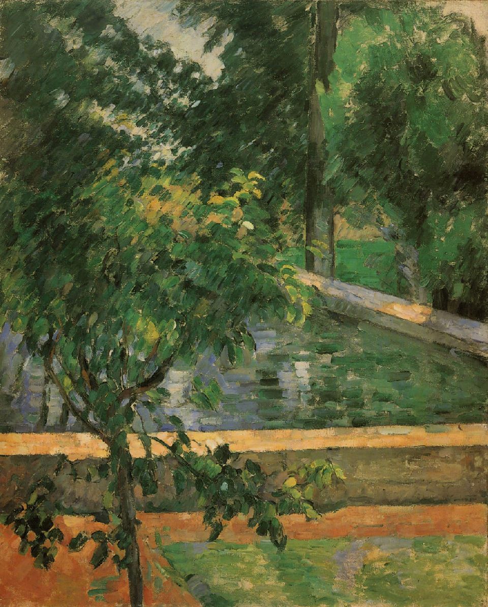
Bassin au Jas de Bouffan, 1885-87, huile sur toile
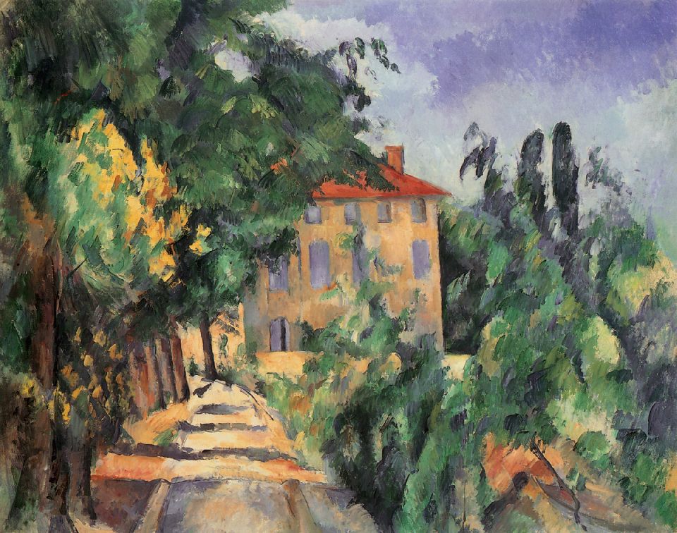
J’ai appris pendant le tour de la maison et ses terres qu’elles ont subi beaucoup de changements depuis la mort de Cèzanne en 1906. Par exemple, comme expliquait notre guide, beaucoup des châtaigniers qui avaient dominé la propriété pendant la vie de Cézanne sont morts à la suite de la construction d’une autoroute au sud de la propriété, parce que l’autoroute avait bloqué la circulation des eaux naturelles à la propriété. On avait mis des platanes à la place de beaucoup de ces châtaigniers, parce que les platanes poussent bien dans des conditions sèches. Beaucoup de végétation naturelle a poussé aussi dans d’autres parties des terres. En conséquence de ces changements, plusieurs des vues du Jas de Bouffan qu’on peut voir dans les tableaux peints par Cézanne ne se voient plus dans les terres comme elles existent aujourd’hui. En particulier, on ne peut plus voir le Mont Sainte-Victoire depuis le Jas de Bouffan comme il apparaît dans le tableau ci-dessous, peint par Cézanne dans les années quatre-vingt:
Châtaigniers au Jas de Bouffan, 1885-87, huile sur toile
Le Mont Sainte-Victoire est une montagne calcaire gigantesque et solitaire qui se trouve plusieurs kilomètres à l’est d’Aix-en-Provence, et qui était un sujet favori de Cézanne. Il a fait 87 tableaux de la montagne pendant sa vie, y compris 44 peintures à l’huile et 43 aquarelles. Bien que j’étais un peu déçu de ne pouvoir pas voir la montagne depuis le Jas de Bouffan, plus tard j’avais beaucoup d’occasions pour la voir et photographier depuis d’autres sites aux environs d’Aix. Vous pouvez voir les résultats de ces efforts à Dans les Pas de Cézanne (IIème Partie) et à Dans les Pas de Cézanne (IIIème Partie).
Pour voir des photos supplémentaires d’Aix-en-Provence et photos d’autres villes et villages de Provence et la Côte d’Azur, veuillez visiter la galerie Provence-Côte d’Azur de mon site de Web photographique. Pour obtenir plus d’informations sur ma photographie, vous pouvez visiter aussi ma page photographique de Facebook.
Phil Haber
Copyright © 2015 Philip A. Haber
During a three-week stay on the island of Maui, in February, 2015, I finally accomplished something I had thought about doing for some time: witnessing a sunrise on a clear morning at the top of Mt. Haleakala, the huge dormant volcano that forms most of the eastern portion of Maui. While I had been to the top of the mountain on a number of previous occasions, including during previous visits to the island, getting there at just the right time and in just the right weather conditions is not as easy as it might first appear. The Haleakala Highway, the single, 36-mile-long road to the summit, traverses more than 50 single-lane bridges and winds through dozens of hairpin turns, often at the edge of steep drops. The drive from the bottom to the top generally takes at least an hour, in addition to the time it takes to get to the entry point of the highway from wherever you may be staying on the island. There is of course no guarantee that, even if the weather on the island is clear when you start your journey in the dark early morning hours, it will still be clear when you arrive at the summit.
During February, sunrise on Maui occurs at about 7:00 am, and to be assured of a parking space at the Visitors’ Center at the top you need to arrive no later than 5:45 am. (2017 UPDATE: You now need an advance reservation to get into the park for sunrise. Reservations can be obtained here: https://www.nps.gov/hale/planyourvisit/haleakala-sunrise-reservations.htm.) From the apartment where I was staying in Kihei on this trip, the drive to the top would take about 1-1/2 hours. My journey to the top therefore began at about 4:15 am and I arrived at the summit at almost exactly 5:45 am, just in time to grab the last available parking space. The weather on Maui that morning was mostly clear and there was a wonderful star-lit sky with a crescent almost-new moon. While there were some clouds around the edge of the mountain, their tops were at an elevation of about 5,000 feet, almost a mile below the summit of the volcano.
Mt. Haleakala is more than 30 miles wide at the base and occupies virtually the entire eastern (larger) portion of the island, occupying about 75% of the land area of Maui. The upper portion of the volcano is contained within Haleakala National Park. Once you pass the entry point of the park, you still have about 10 miles to go to reach the summit. The park Visitors’ Center at the top of the mountain is at an elevation of about 10,000 feet. On the morning of my visit there, the air temperature was about 43° F, with a fairly strong wind. In expectation of the low temperature, I was wearing several layers of clothing. At this altitude, the air is thin and it is a good idea to limit your exertions to those that are absolutely necessary.
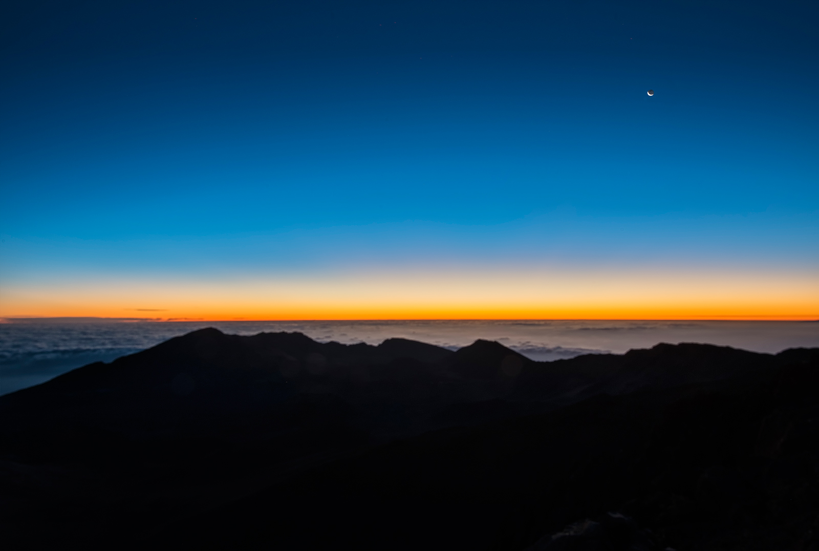
Behind and to the right of the Visitors’ Center, a metal railing runs along the top of the rim of the volcano. Beyond the rim is an immense crater about 7 miles long and over 2 miles wide. At the railing, you face directly east, and so the sunrise appears at the opposite end of the crater and across its entire expanse. However, upon my arrival at 5:45 am, the crater was entirely dark, and only a faint glow of light appeared in the distance, together with a crescent moon above and to the right. By about 6:05 am, however, the glow had developed faint but distinct orange and blue colorations, and looked like this:

50 Minutes Before Sunrise
The orange and blue colors gradually brightened, and by 6:15 am, which was about 40 minutes before sunrise on the date of my visit, the scene looked like this:

40 Minutes Before Sunrise
As the sun approached the horizon from below, the sky brightened, the orange and blue colors expanded upward into the morning sky, and an outline appeared of the edge of the crater on the far side:
20 Minutes Before Sunrise
Just before the rim of the sun broke above the horizon, bright orange sparkles appeared. Finally the sun made its appearance above the horizon. As it rose, it began to illuminate the dark interior of the volcano’s crater. Beyond the far rim, a layer of clouds, situated a few thousand feet below the level of the crater, stretched to the horizon. As the sun appeared, a park staff member chanted a traditional Hawaiian greeting.

After the sun rose above the horizon, it further illuminated the interior of the crater with a reddish glow:
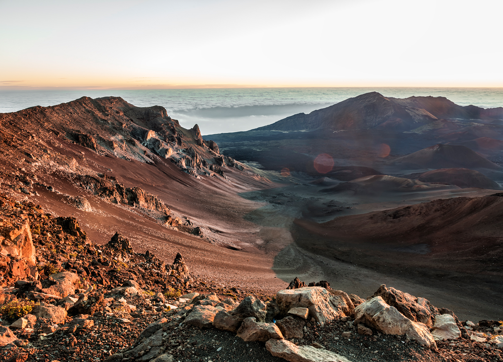
The Crater after Sunrise
Experiencing a Haleakala sunrise is very different from watching a beautiful sunrise at sea level. Up here, you feel that you are part of the greater cosmos. This is a magical experience not to be missed by any visitor to Maui.
For other photographs of Hawaii, please visit the Hawaii Gallery of my website. Please also visit my photography Facebook page.
Phil Haber
Copyright © 2015 Philip A. Haber

As every photographer knows, when shooting outdoors, an essential component of any photograph is the available light. In the open air, the photographer is subject to the vicissitudes of terrain and weather, which to a large extent determine the nature and quality of the available light. However, one factor that remains within the photographer’s control is the choice of the time of day to shoot. My favorite time of day to take photographs, particularly when traveling, is at dawn, both just before and just after sunrise. The early morning light before sunrise is gentle and even, suffusing the entire scene without creating dark shadows or strong highlights that can reduce or eliminate detail. If there are thin clouds in the sky, they may pick up orange, pink and purple colors from a sun still below the horizon. In town, the streets are deserted, without moving automobiles or pedestrians, and the photographer can roam the streets and concentrate on the architectural detail without interference. Later, when the sun first appears above the horizon, it casts a soft reddish light that gives a warm glow to buildings and trees.
Some of my early morning photographs have already appeared in previous blog posts here. For example, all of the photos shown in my article entitled A Photographic Tour of Saint-Paul-de-Vence, other than the first two, were taken in the early morning at first light. The details of the ancient stone buildings and alleys of that medieval village seem almost magnified in the soft light of dawn.
In fact, the beautiful architecture of many old European cities seems to take on a special aura at first light. This can be seen in a number of early morning photos which I took a couple of years ago while in Edinburgh, Scotland. I awoke before dawn on a Sunday morning and peered out of the window of my hotel, which was located on the Royal Mile, where many of the city’s historical attractions are situated. I was greeted by a beautiful clear pre-dawn sky which, as frequent visitors to Scotland will attest, is not something that can always be counted on in that otherwise wonderful country. I hastily got dressed, picked up my camera (Nikon D800 with a Nikon 24-70 mm f/2.8 lens) and tripod, and headed down to the street. At about 6:30 AM on Sunday morning, the sun was still below the horizon and the city was half-dark and virtually deserted. I walked to a suitable spot and photographed the view down the Royal Mile facing east (click on any photo in this article to see a larger version):
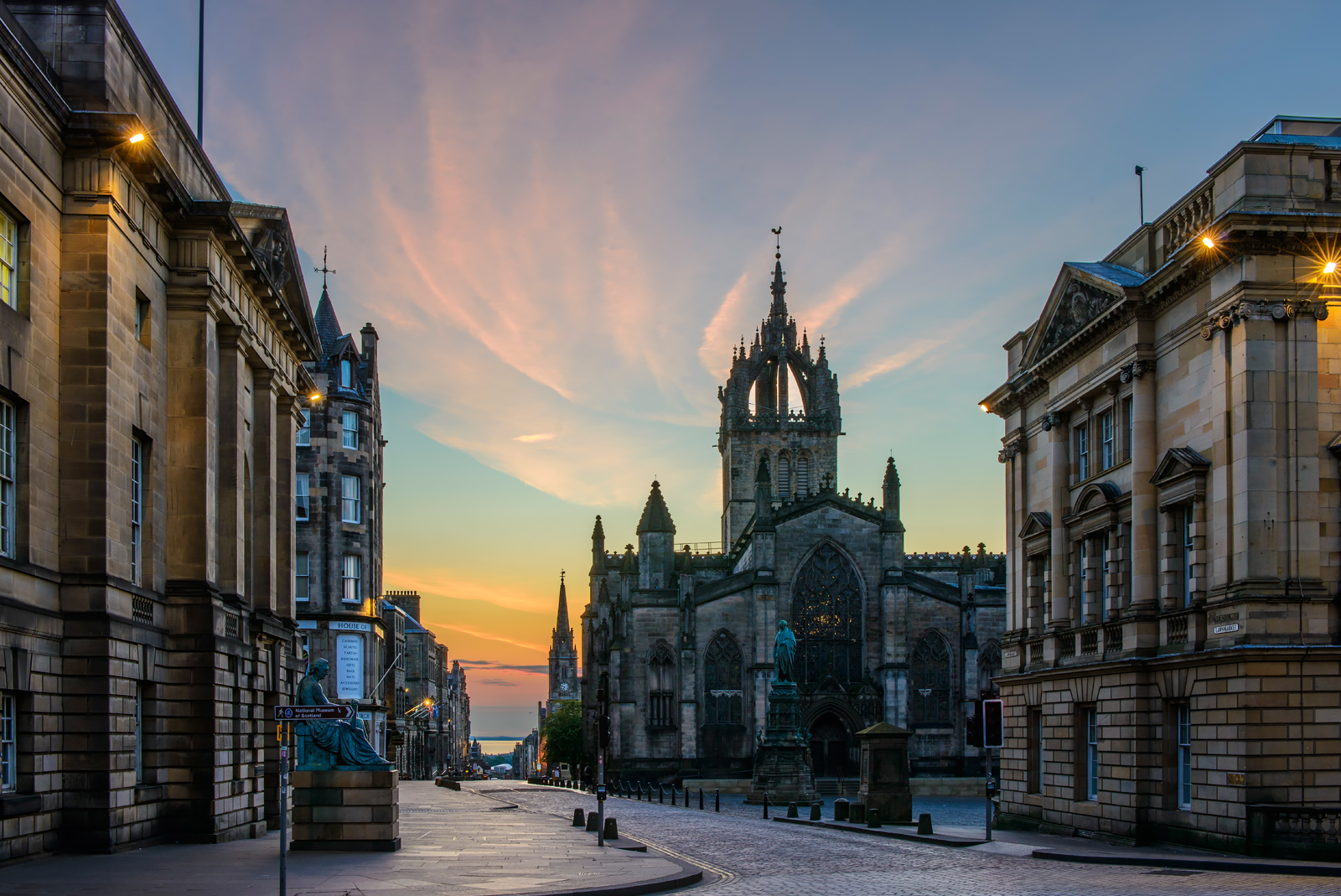
The Royal Mile, Edinburgh
In this sort of low light, a tripod is almost always a necessity. In order to obtain corner to corner sharpness and the least possible noise, it is usually advisable to use a small aperture and a low ISO, and as a result a fast shutter speed will be unavailable. The above photograph of the Royal Mile was taken with an aperture of f/14 at ISO 100, resulting in a shutter speed of 0.3 seconds, so a handheld shot was out of the question.
The building in the center of the above photo is St. Giles Cathedral, which dates mostly from the late 14th century (the unusual “crown steeple” from the late 15th century), and was extensively restored during the 19th century. Here is a photo St. Giles from the east side, taken at about the same time:

St. Giles Cathedral
The building is suffused with warm pre-dawn light, here coming from behind the camera. At left, a statue of the Scottish economist Adam Smith is visible.
It had also been my aim to record an unobstructed view of Edinburgh Castle. The castle is located at the western end of the Royal Mile. However, to obtain a view of the entire castle together with the rocky outcropping on which it sits, it is necessary to walk a considerable distance off the Royal Mile. This shot was taken from Princes Street, on the other side of the railroad tracks from the Royal Mile, after about a half hour’s walk:

Edinburgh Castle
As you can see, by the time I reached this spot, the sun was already above the horizon, its light illuminating the upper parts of the castle.
Aix-en-Provence, France, is another town which is ideal for early morning photography. Normally a busy city with streets full of cars and sidewalks and cafes full of tourists and university students as well as local residents, in the early morning hours just before or just after dawn it is beautiful and quiet. Here is the Place Séraphin Gilly at dawn on a Sunday morning:
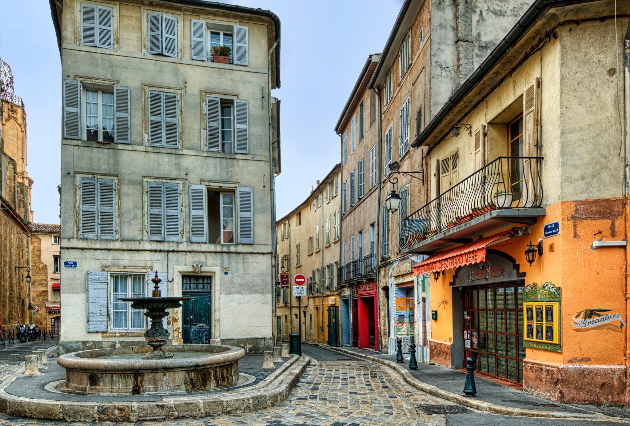
Place Séraphin Gilly, Aix-en-Provence
The principal street in Aix is the Cours Mirabeau, which extends from the circular Rotonde with its large fountain eastward to the Place Forbin. Along the way are several cold water and natural hot water fountains. Aix has been known since ancient Roman times for its natural hot springs. In fact its name derives from its Latin name “Aquae Sextius,” meaning waters of Sextius. Gaius Sextius Calvinus was the Roman consul who founded Aix about 122 BC as the first Roman city in the territory of today’s France. This is an early morning shot of the Cours Mirabeau, before the street became filled with the morning traffic:
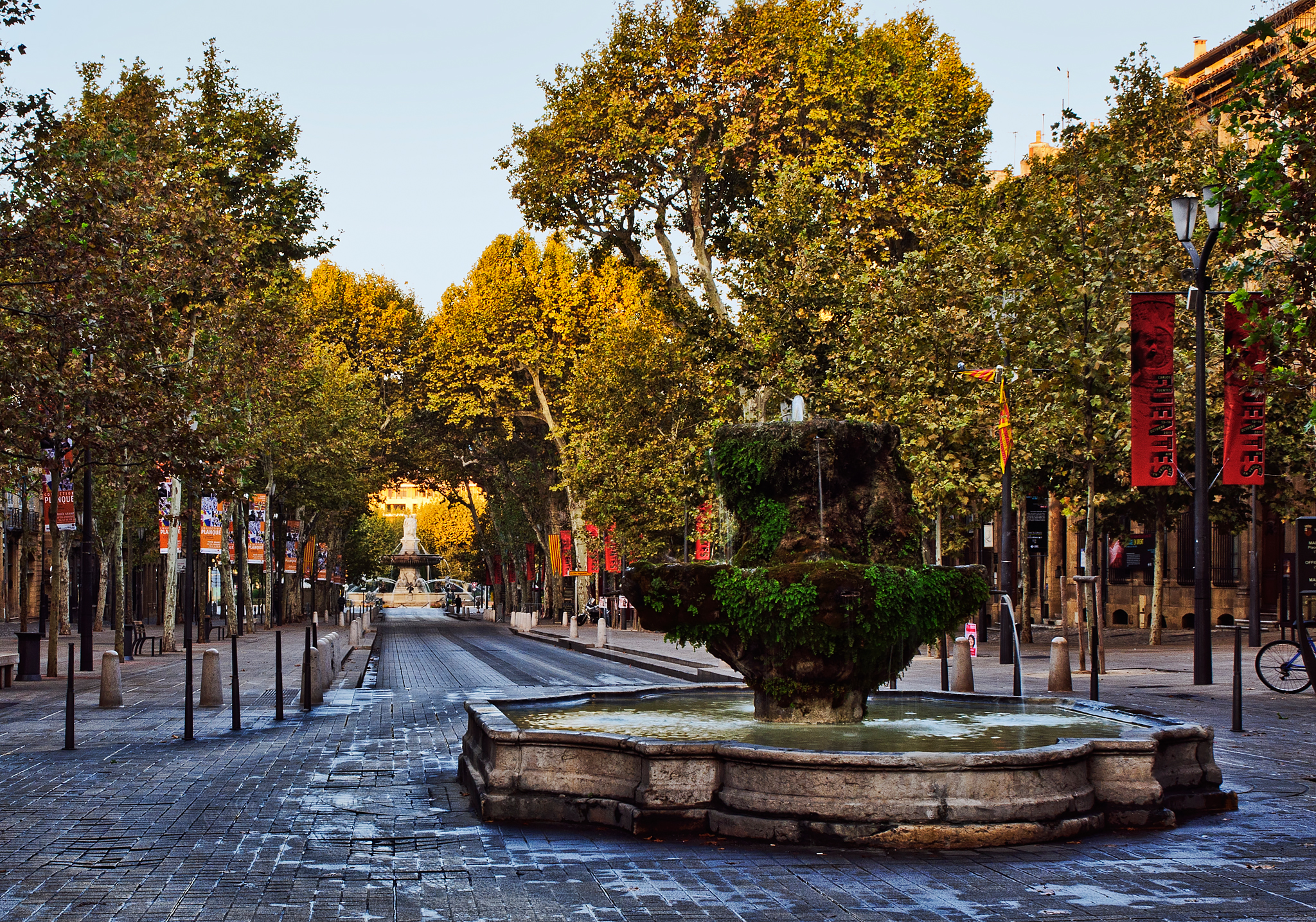
The Cours Mirabeau
In the foreground is the Fontaine des Neuf Canons, built around 1691. The term “canons” here refers not to weapons of war but to the pipes that spout water from the fountain, of which in the case of this fountain there are nine, as the name implies. At the end of the avenue in the distance can be seen the large fountain of the Rotonde.
My love for early morning photography began some years ago when I was serving as production stills photographer during the shooting of “The Man at the Counter”, a short film shot mostly in the town of Hudson, New York. As is customary in such settings, the cast and crew were off to an early start the first morning, setting up on a nearly empty street at about 7:00 am. The town had cooperated by blocking off a portion of Warren Street, the town’s main street, for a few hours to facilitate unobstructed filming. After taking some preliminary shots of the cast and crew, I looked about for a scenic shot and found this view of Warren Street, looking west toward the Hudson River:

Warren Street, Hudson, NY at Dawn
This shot has been one of my most popular photos, and appeared in the November, 2013 issue of Architectural Digest. I was inspired enough by the early morning light that weekend to get out even earlier the next day, before the crew even began to set up. Walking down to the east bank of the Hudson River, I took this shot of the Hudson-Athens Lighthouse, which sits on a tiny island in the middle of the river between the town of Athens, on the west bank, and Hudson on the east bank:

The Hudson-Athens Lighthouse
This photo also found its way into Architectural Digest, in an article entitled Great American Lighthouses.
More recently, I had an opportunity for early morning photography in the gorgeous California town of Carmel-by-the-Sea, where I was staying for a few days last spring in a house just a few blocks from the beach. The following shot was taken just after sunrise from the edge of the Scenic Road, the street that runs alongside the cypress-lined beach:
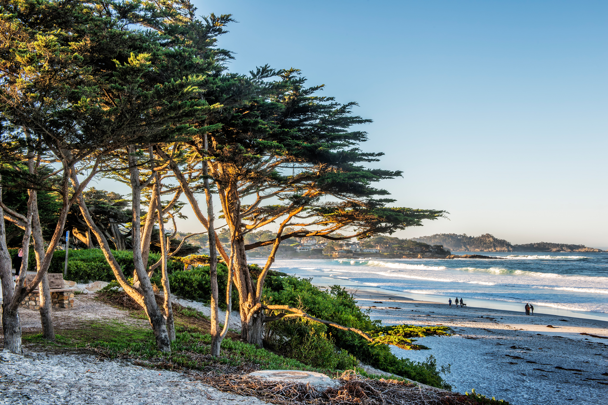
The Beach at Carmel
Carmel’s famous “fairy tale” architecture also photographs well in early morning light. Here, for example, is the “Tuck Box”:

The Tuck Box, Carmel
And this is Carmel’s version of the great American shopping center:

The Court of the Golden Bough
While we are on the subject, here is a recent addition from a trip to Quebec City. The early morning sky was overcast, but a break in the clouds allowed the sun, which was just above the eastern horizon, to illuminate the Château Frontenac Hotel and create a strong contrast with the dark sky:

Château Frontenac Hotel, Quebec City
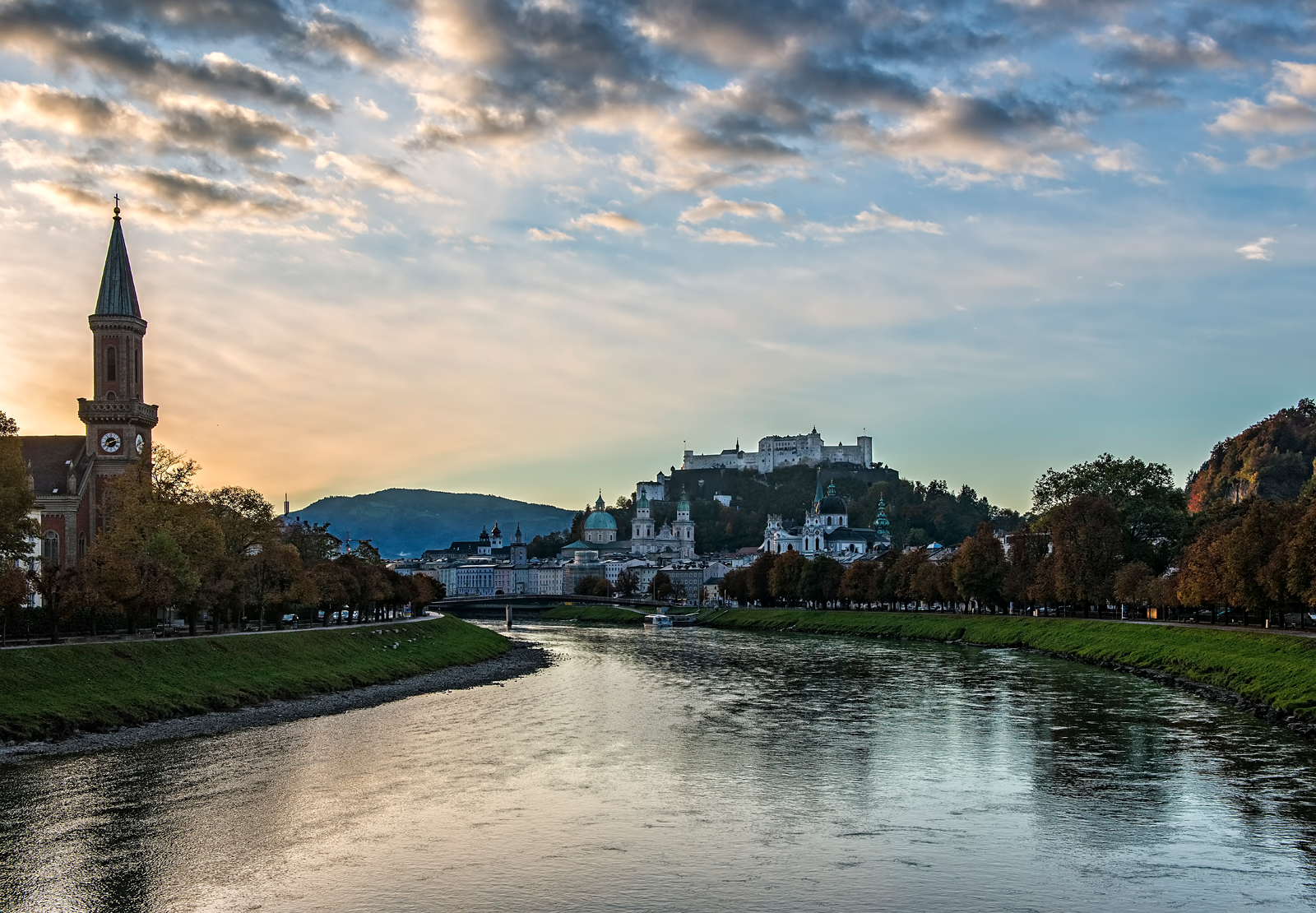
On a recent trip to Salzburg, Austria, I got out early one morning and took these three photographs from a bridge over the Salzach River some distance from the town center:


By the way, early morning is also a great time for wildlife photos. Here is a shot of a great blue heron, standing on a raft in a pond, lit from the side by an early morning sun:

Great Blue Heron
My all time favorite early morning shot is this photo of Hanalei Bay, on the north shore of the Hawaiian island of Kauai, taken just after sunrise from the deck of the St. Regis Princeville Resort. Click to enlarge!

Hanalei Bay
The photographs shown in this blog are available for purchase as prints or (in most cases) as downloads for personal use on my photography website at http://www.philhaberphotography.com. You are also invited to visit and hit the “Like” button on my photography Facebook page, located at http://facebook.com/PhilHaberPhotography.
Phil Haber
Copyright © 2014 Philip A. Haber
(Note: An English version of this post may be found at https://philhaber.com/2011/12/21/a-photographic-tour-of-roussillon/)
En octobre 2011, j’ai passé quatre semaines à Provence et la Côte d’Azur. Pendant cette période j’ai réservé une journée entière pour visiter Roussillon, un village situé dans le Luberon. Le Luberon est une région montagneuse dans le département de Vaucluse au nord d’Aix-en-Provence. Le trajet d’Aix, òu j’avais loué un appartement, à Roussillon fait environ 60 kilomètres de long, mais on met beaucoup plus q’une heure pour y aller même par les routes les plus directes. Les routes étroites serpentent autour des collines et à travers des vallées pittoresques, et traversent d’autres villages aux coteaux, y compris Bonnieux et Lourmarin qui eux-mêmes méritent une visite d’au moins un jour.
Roussillon est assis sur des dépôts énormes d’ocre rouge, orange et jaune. Les couleurs de l’ocre sont les effets d’oxydes de fer de genres variés qui y se sont déposées il y a plus de cent millions d’ans, quand la terre qui aujourd’hui constitue la Provence se trouvait au fond de la mer. En entrant dans le village, on voit en premier une grande falaise d’ocre en face du côté est du village (vous pouvez cliquer sur n’importe quelle image dans ce blog pour en voir une copie plus grande):
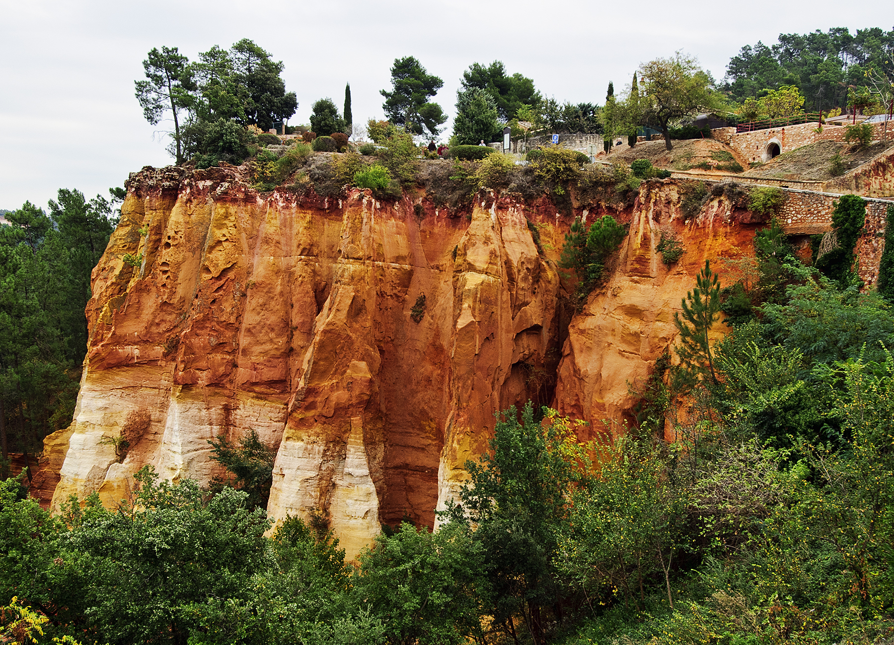
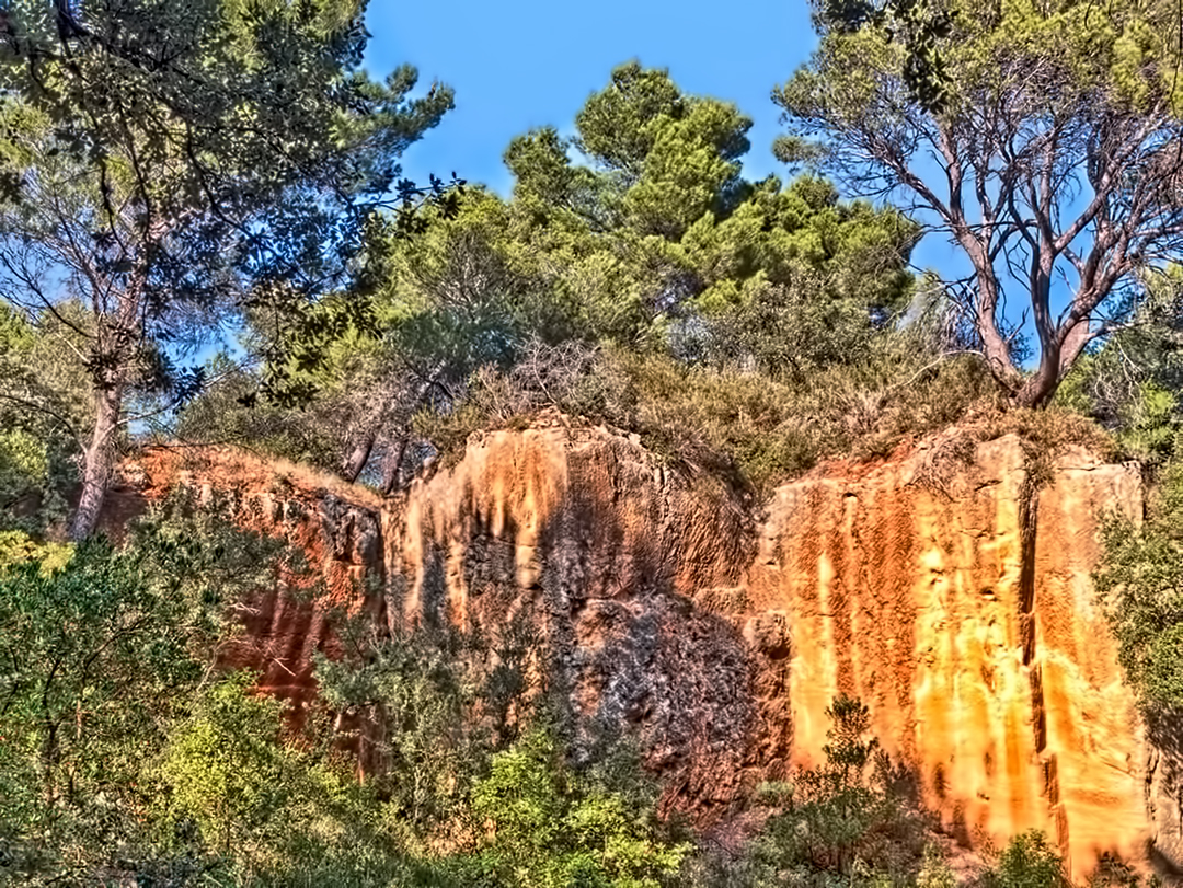
Après une courte promenade le long du haut de cette falaise, on arrive aux carrières d’ocre, òu pendant des siècles on a miné les matériaux qu’on a utilisés pour construire les bâtiments du village. Dans les carrières on voit beaucoup de formes colorées et fantasques comme ceux-ci:

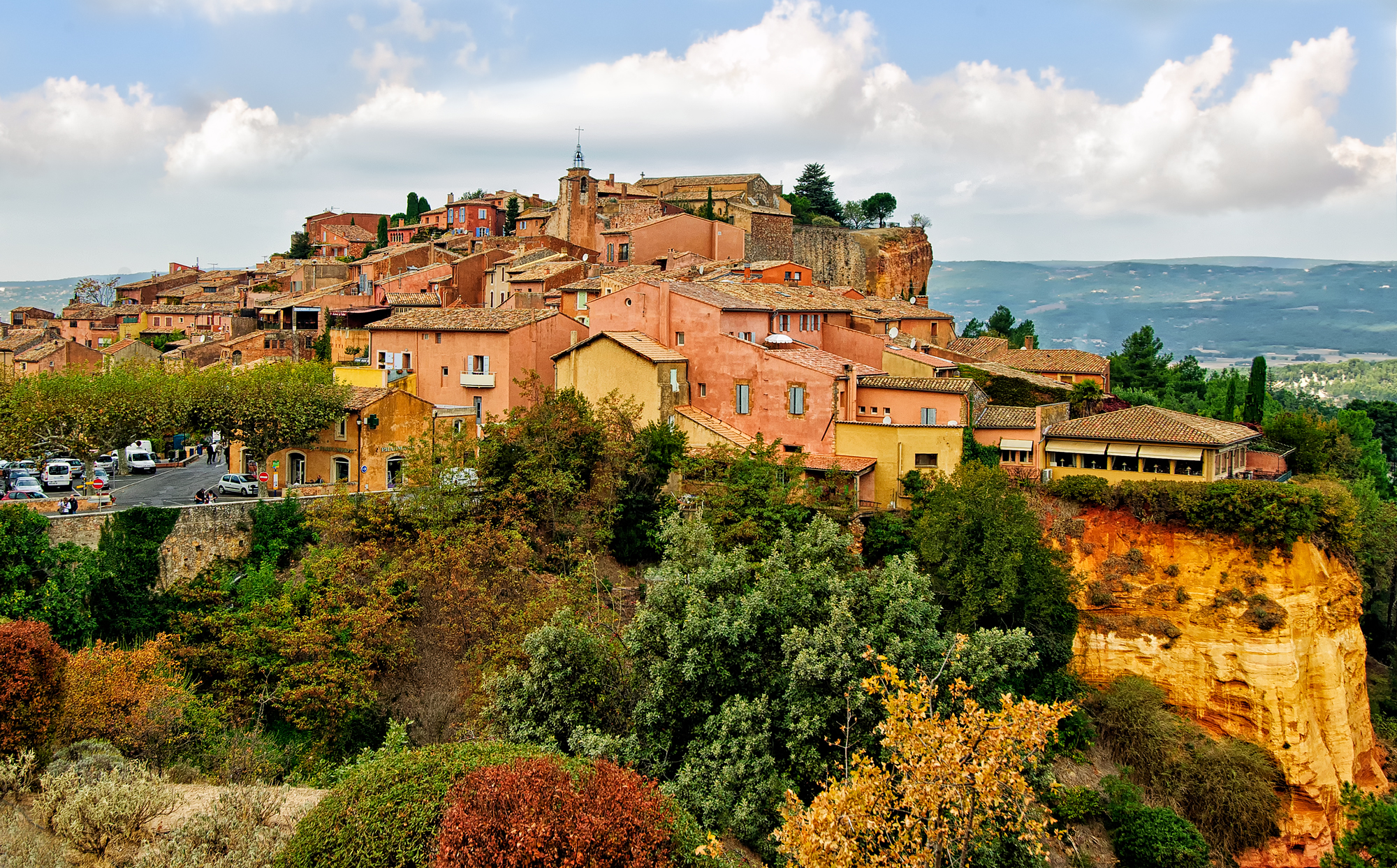
Du haut de la falaise, il y a une vue du village d’une beauté frappante:
Au centre du village, les couleurs de l’ocre – rouge, orange et jaune – se trouvent partout:

Comme on voit dans beaucoup de villages en Provence, il y a ici une belle tour d’horloge ancienne:

À l’autre côté de la tour d’horloge, j’ai pris une photo à travers l’arche d’en bas:

Au fait, les couleurs de l’ocre se voient dans toutes les rues du village:

Les portes et les volets des fenêtres montrent des couleurs qui s’accordent ou contrastent avec les couleurs prédominantes de l’ocre des murs:


On peut vite comprendre pourquoi le village de Roussillon est inclus dans la liste des “Plus Beaux Villages de France”. Une visite à Roussillon est une expérience inoubliable.
On peut voir et acheter copies des photos ci-dessus et d’autres photos de Roussillon et d’autres villages en Provence et la Côte d’Azur à mon site de web photographique, dans la galerie Provence-Côte d’Azur. Pour obtenir plus d’informations sur ma photographie, veuillez visiter aussi ma page photographique de Facebook.
Phil Haber
Copyright © 2012 Philip A. Haber
(Note: An English version of this post may be found at https://philhaber.com/2013/08/23/a-voyage-through-history-on-the-dordogne/)
(Révisé en 2015). Récemment j’ai voyagé à la région de la Dordogne une troisième fois – j’y avais voyagé deux fois auparavant, il y a onze ans et il y a deux ans. Une visite à cette région (aussi appellée Périgord) est un voyage à travers l’histoire, même à travers la préhistoire. Châteaux du Moyen Âge ou de la Renaissance donnent sur le fleuve à plusieurs sites, et centaines d’autres châteaux se trouvent presque partout dans la région. Sur les rives de la Dordogne et de son affluent, la Vézère, on trouve des falaises calcaires gigantesques, qui sont percées à beaucoup de sites par des grottes qui maintes fois étaient utilisées comme abris par les riverains des villages proches pendant les guerres fréquentes du Moyen Âge. Sur les murs intérieurs de quelques grottes, par exemple les grottes de Lascaux, de Rouffignac et du Font de Gaume, se trouvent des images de mammouths, de bisons, de taureaux, de chevaux, de rennes et d’autres animaux que des hommes Cro-Magnons y ont dessinées, peintes ou gravées il y a 12.000 à 18.000 ans.
Une voiture est nécessaire pour voir toutes les choses en cette région qui méritent une visite. Mais aussi on ne doit pas omettre une promenade en bateau sur la Dordogne. Des kayaks et canoës sont très populaires et sont à louer à beaucoup de sites sur les rives du fleuve. Aussi au village de La Roque-Gageac on peut acheter un billet pour une promenade d’une heure dans une Gabare Norbert, qui va de La Roque-Gageac à Castelnaud-la-Chapelle et retourne, pilotée par un capitaine qui sert aussi comme guide touristique. Les Gabares Norbert sont des répliques des bateaux à voile et à fond plat qui portaient des marchandises sur la Dordogne et d’autres fleuves de France pendant les 18ème et 19ème siècles. Mais les gabares d’aujourd’hui sont equipées de moteurs fiables qui vous assurent d’une promenade assez confortable. Voici une photo d’une Gabare Norbert qui va arriver à quai à La Roque-Gageac (vous pouvez cliquer sur n’importe quelle image dans ce blog pour en voir une copie plus grande):

Gabare Norbert
Le bateau part du quai à La Roque-Gageac, un des “Plus Beaux Villages de France”:

La Roque-Gageac
En aval de La Roque-Gageac, la gabare passe le Château de La Malartrie, bâti en style Renaissance, qui apparaît au bord gauche de la photo ci-dessus. Voici une vue du château de plus près:

Le Château de La Malartrie
Puis la gabare continue à glisser en aval jusqu’au village de Castelnaud-la-Chapelle:

Castelnaud-la-Chapelle
Le Château de Castelnaud surplombe le village. Bâti pendant le 12ème siècle, ce château était un site important de la Guerre de Cent Ans (1338-1453) et était occupé par l’armée anglaise pendant la plupart de cette guerre. Voici une vue du château de plus près depuis le centre du village:

Le Château de Castelnaud
Du haut du Château de Castelnaud, il y a une vue merveilleuse de la Dordogne jusqu’au village de Beynac-et-Cazenac, qui est surplombé par le Château de Beynac:

Vue de la Dordogne depuis le Château de Castelnaud
Le Château de Beynac était bâti pendant le 12ème siècle par les barons de Beynac, dont Richard Coeur de Lion, qui était baron de Beynac de l’an 1189 à l’an 1199. Ce château était un autre point central de la Guerre de Cent Ans. Situé environ trois kilomètres en aval du Château de Castelnaud et sur la rive opposée du fleuve, le Château de Beynac était occupé par l’armée française. Il se perche en haut d’une falaise imposante et donne sur cette partie du fleuve:

Le Château de Beynac
Pas loin du Château de Castelnaud se trouve le Château des Milandes. Bâti pendant le 15ème siècle, le château est devenu pendant le 20ème siècle la résidence de la chanteuse/danseuse/actrice américaine Josephine Baker. Ne pouvant pas réussir dans son propre pays à cause de sa race, Baker a néanmoins gagné un succès immense en France:

Le Château des Milandes
Un peu en amont de La Roque-Gageac, perché sur une falaise qui donne sur la Dordogne, est situé le village de Domme, aussi membre de la liste des “Plus Beaux Villages de France.” Au bord de la falaise, près du restaurant bien nommé “Le Belvédère,” s’étend une terrasse de béton d’où il y a une vue spectaculaire du fleuve et de sa valleé:

Vallée de la Dordogne
On peut entrer au village de Domme par l’imposante Porte des Tours, qui était utilisée comme prison pour 70 Chevaliers Templiers pendant le 14ème siècle:

La Porte des Tours de Domme
Voici deux beaux bâtiments médiévaux qui se trouve dans la Place de la Rode à Domme. Le bâtiment à droite, bâti en 1282, qui maintenant contient une bijouterie de bonne qualité, était jadis la “maison du batteur de monnaie du Roy Philippe III le Hardi,” comme on peut voir d’une inscription ciselée dans un bloc de pierre au mur extérieur du bâtiment. (Philippe le Hardi était roi de France de l’an 1270 à l’an 1285.) Le bâtiment à gauche est maintenant le restaurant-café “Le Médiéval.”

Dans la Place de la Rode, Domme
À Domme, j’ai aussi acheté des belles faïences artisanales à la boutique “Les Coquelicots.”

Comme j’ai indiqué déja ci-dessus, des randonnées sur la Dordogne en kayak ou canoë sont très populaires et offrent de belles occasions pour la photographie. Voici une photo de La Roque-Gageac prise d’un canoë sur le fleuve:

En kayak sur la Dordogne
Les attractions spectaculaires de Périgord ne se bornent pas à celles situées aux rives du fleuve. La region est remplie de centaines de châteaux et d’autres attractions touristiques du Moyen Àge et de la Renaissance, et effectivement est appellée le “Pays de 1001 Châteaux”, y compris le Château de Puymartin. Ce château était bâti pendant le 13ème siècle, était détruit pendant la Guerre de Cent Ans, et était rebâti pendant le 15ème siècle. Des membres de la même famille ont possédé et habité le château depuis l’an 1450.

Le Château de Puymartin
Pas loin du Château de Puymartin se trouve la ville de Sarlat-la-Canéda, la ville principale de cette partie de Périgord. On a soigneusement conservé le centre médiéval de cette ville:

Place de la Liberté, Sarlat-la-Canéda
Sarlat est rempli d’histoire. Le panneau au mur de la maison dans la photo ci-dessous déclare que Étienne La Boétie est né dans cette maison le 1er Novembre 1530. La Boétie etait écrivain, diplomate, juge et créateur de la philosophie moderne française de la politique. Mais aujourd’hui il est peut-être plus fameux comme ami du philosophe Michel de Montaigne.

Maison d’Etienne La Boétie
Le samedi il y a un grand marché à Sarlat qui est très populaire:

Le Marché à Sarlat
La beauté de Sarlat ne se montre pas seulement de jour, mais aussi à la nuit. Sarlat est peut-être la seule ville française qui est encore illuminée pendant la nuit seulement par des lampes à gaz.

Le Soir à Sarlat
Le château le plus étrange qu’on peut trouver dans la région de la Dordogne est peut-être la Maison Forte de Reignac:
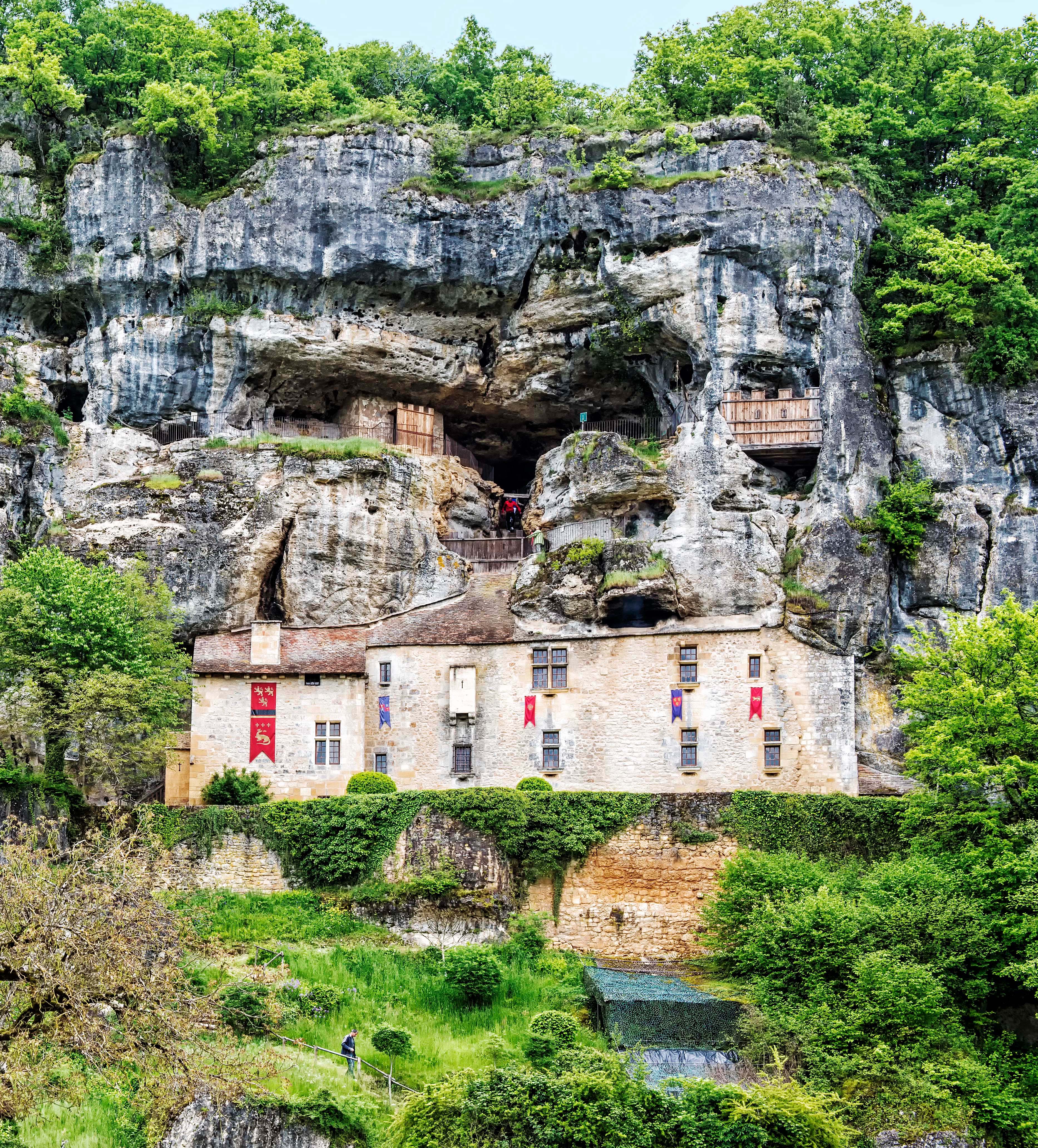
Maison Forte de Reignac
Bâtie au flanc d’une falaise calcaire proche de la Vézère, la façade cache des immenses espaces intérieurs à beaucoup de niveaux. Depuis environ l’an 1300, il était construit et occupé comme château d’un baron. Encore aujourd’hui les salles et les chambres du château sont meublées élégamment comme au 16ème siècle. Et il y a aussi beaucoup d’évidence que le site était occupé par des gens Cro-Magnons il y a 20.000 ans, comme beaucoup d’autres sites dans cette région.
Un petit village de cette région à ne pas manquer est Saint-Cyprien. Ce village est plein de belles rues comme celle-ci:

Belle rue à Saint-Cyprien
Aussi on y trouve beaucoup de belles façades de maisons comme celle-ci:

Façade de maison à Saint-Cyprien
Le dimanche matin il y a un marché merveilleux à Saint-Cyprien qui se répand le long de la Rue Gambetta, qui est la rue principale du village. Voici un étal d’olives pittoresque au marché:

Étal d’olives au marché de Saint-Cyprien
Parmi les attractions de la région qui valent aussi une visite sont Les Eyzies de Tayac, qui contient le site du découvert original de l’homme Cro-Magnon et le Musée National de la Préhistoire. Aussi à ne pas manquer est Lascaux II, situé à Montignac, qui est une réplique de la grotte originale de Lascaux qui contient des peintures préhistoriques de renommée mondiale.
Quand je voyage à la region de la Dordogne, je loge toujours à Les Hirondelles, une propriété idyllique située dans le très petit village de Carmensac Haut, qui se trouve sur la Route D48 entre Meyrals et Les Eyzies de Tayac. La propriété etait jadis, il y a 300 ans, une abbaye et contient plusieurs bâtiments de pierre, y compris la maison des propriétaires, un gîte d’une chambre (“Butterfly Cottage”) et une grande maison de cinq chambres (“Mulberry Tree Villa”). Tout a été modernisé par les propriétaires, un couple américain qui ont aussi installé une piscine chauffée, un jacuzzi, des jardins avec bassins et fontaines, et d’autres améliorations qui font de cette propriété un logement idéal pour tout voyageur. La propriété est située seulement 10 minutes par voiture de Les Eyzies de Tayac et environ une demi-heure de Sarlat-la-Canéda, La Roque-Gageac, le Château de Beynac, le Château de Castelnaud, Domme, le Château des Milandes, Lascaux II et beaucoup des autres attractions principales de la région.

Butterfly Cottage
Comme on peut voir ici, le Périgord est rempli d’une quantité immense de choses belles et fascinantes à visiter et à voir. On peut voir et acheter copies des photos ci-dessus et d’autres photos de Périgord à mon site de web photographique, dans la galerie Dordogne. Pour obtenir plus d’informations sur ma photographie, veuillez visiter aussi ma page photographique de Facebook.
Phil Haber
Copyright © 2015 Philip A. Haber
