(Cliquez ici pour lire une traduction de cet article en français: https://philhaber.com/2013/10/01/un-voyage-a-travers-lhistoire-sur-la-dordogne-version-francaise/.)
(Revised 2015). Recently I traveled to the Dordogne region for a third time, the first having been eleven years ago and the second two years ago. A visit to this area (also known as Périgord) is a voyage through history and even prehistory. Medieval and Renaissance castles look down on the river at several points, while literally hundreds of others dot the region. The Dordogne and its tributary, the Vézère, are lined in many areas with towering limestone cliffs honeycombed with caves that often provided shelter for village residents during the wars of the Middle Ages. Some of these caves, such as those at Lascaux, Rouffignac and the Font de Gaume, contain pictures of animals such as woolly mammoths, bison, bulls, horses and reindeer that were drawn, painted or carved onto the interior walls by Cro-Magnon people 12,000 to 18,000 years ago.
While an automobile is a necessity to get to everything worth seeing in this area, one should not miss an opportunity to ride down the Dordogne itself on a boat. Kayaks and canoes are very popular and can be rented at many locations along the banks of the river. In addition, at the village of La Roque-Gageac, you can book a one-hour ride on a Gabare Norbert, which will take you down the river to Castelnaud-la-Chapelle and back, with a captain who doubles as a tour guide. The Gabares Norbert are replicas of the flat-bottomed sailboats that were used during the 18th and 19th centuries to transport goods along the Dordogne and other rivers in France. These gabares, however, are fitted out with motors that assure a smooth and reliable ride. Here is a photo of a Gabare Norbert about to arrive back in the dock at La Roque-Gageac (you may click on any photo in this article to see a larger version):

Gabare Norbert
The boat leaves from La Roque-Gageac, one of “Les Plus Beaux Villages de France”:

La Roque-Gageac
On the way downstream from La Roque-Gageac, the Gabare Norbert glides past the Renaissance-style Château de La Malartrie, seen on the left side of the photo above. Here is a closer view of the château:
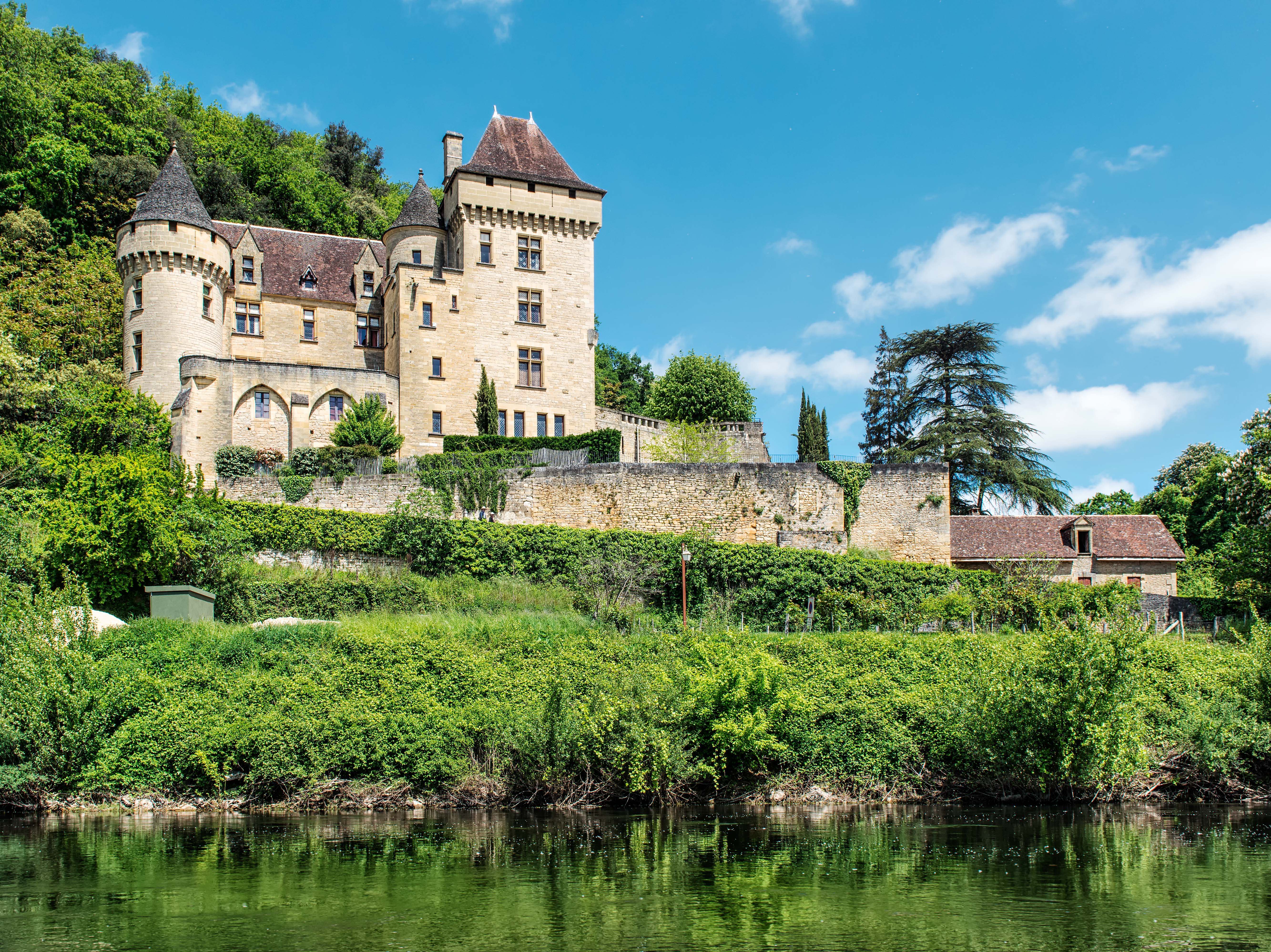
The Château de La Malartrie
The Gabare Norbert then continues downstream to the village of Castelnaud-la-Chapelle:

Castelnaud-la-Chapelle
The village is dominated by the Château de Castelnaud. Built in the 12th century, this castle was a focal point of the Hundred Years War (1338-1453), during most of which it was occupied by English forces. Here is a closer view of the castle from inside the village itself:
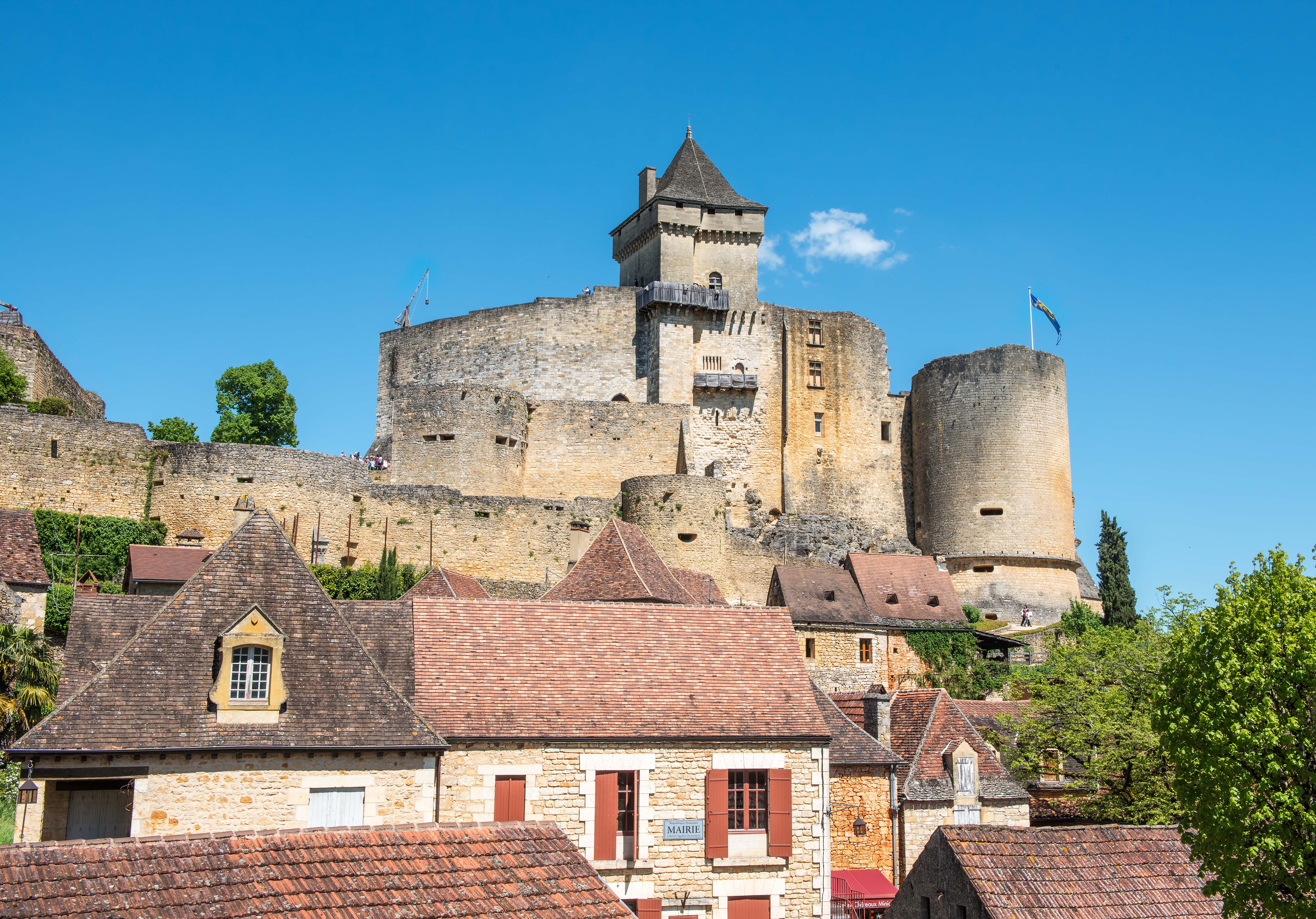
The Château de Castelnaud
From the top of the Château de Castelnaud, there is a marvelous view down the Dordogne to the village of Beynac-et-Cazenac, which is dominated by the Château de Beynac:
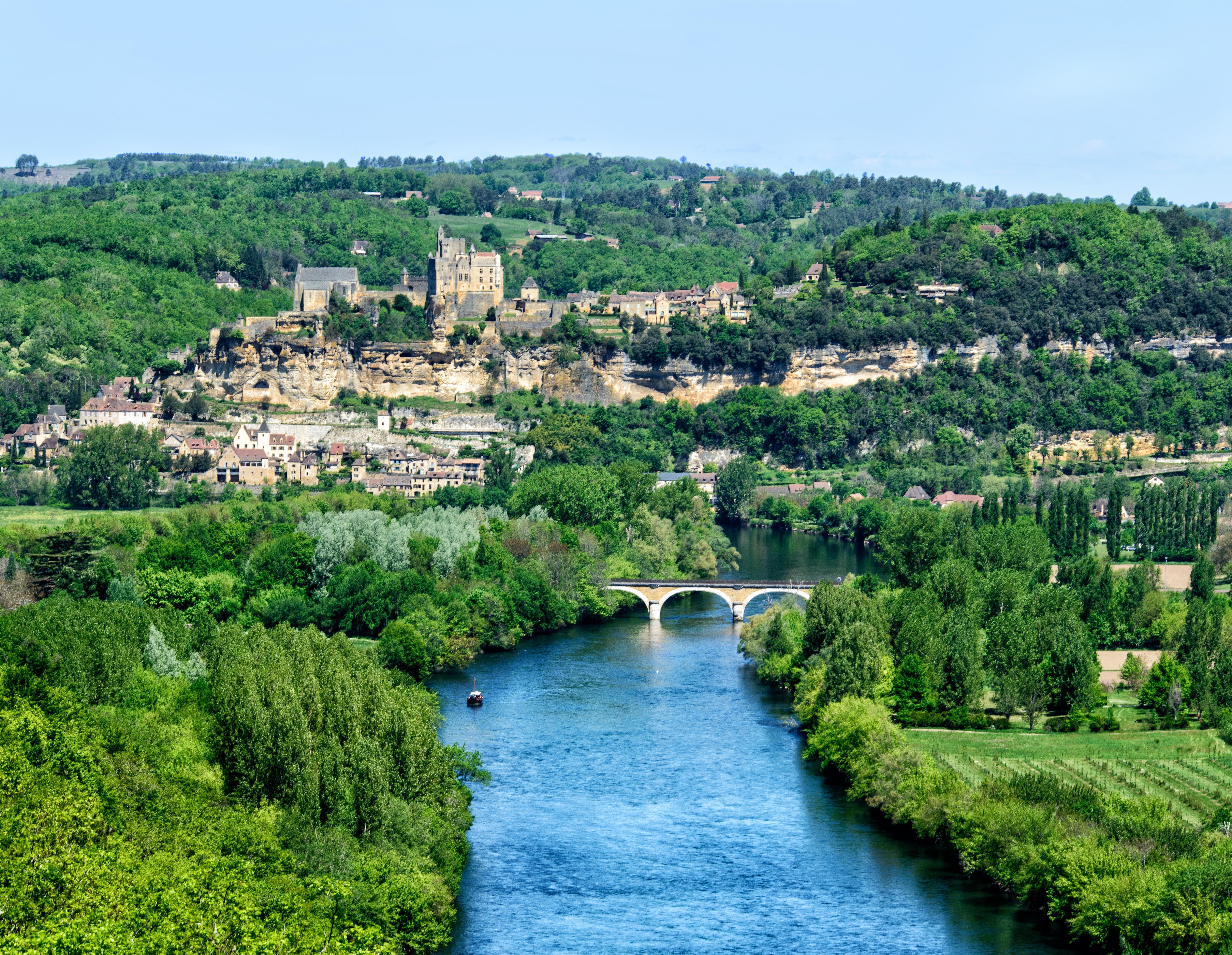
View of the Dordogne from the Château de Castelnaud
The Château de Beynac was built during the 12th century by the barons of Beynac, one of whom, during the period 1189-1199, was Richard the Lionheart. The château was another focal point of the Hundred Years War. Located about two miles downstream from the Château de Castelnaud and on the other side of the river, the Château de Beynac was occupied by the French. It is perched on top of a towering cliff and dominates its section of the river:
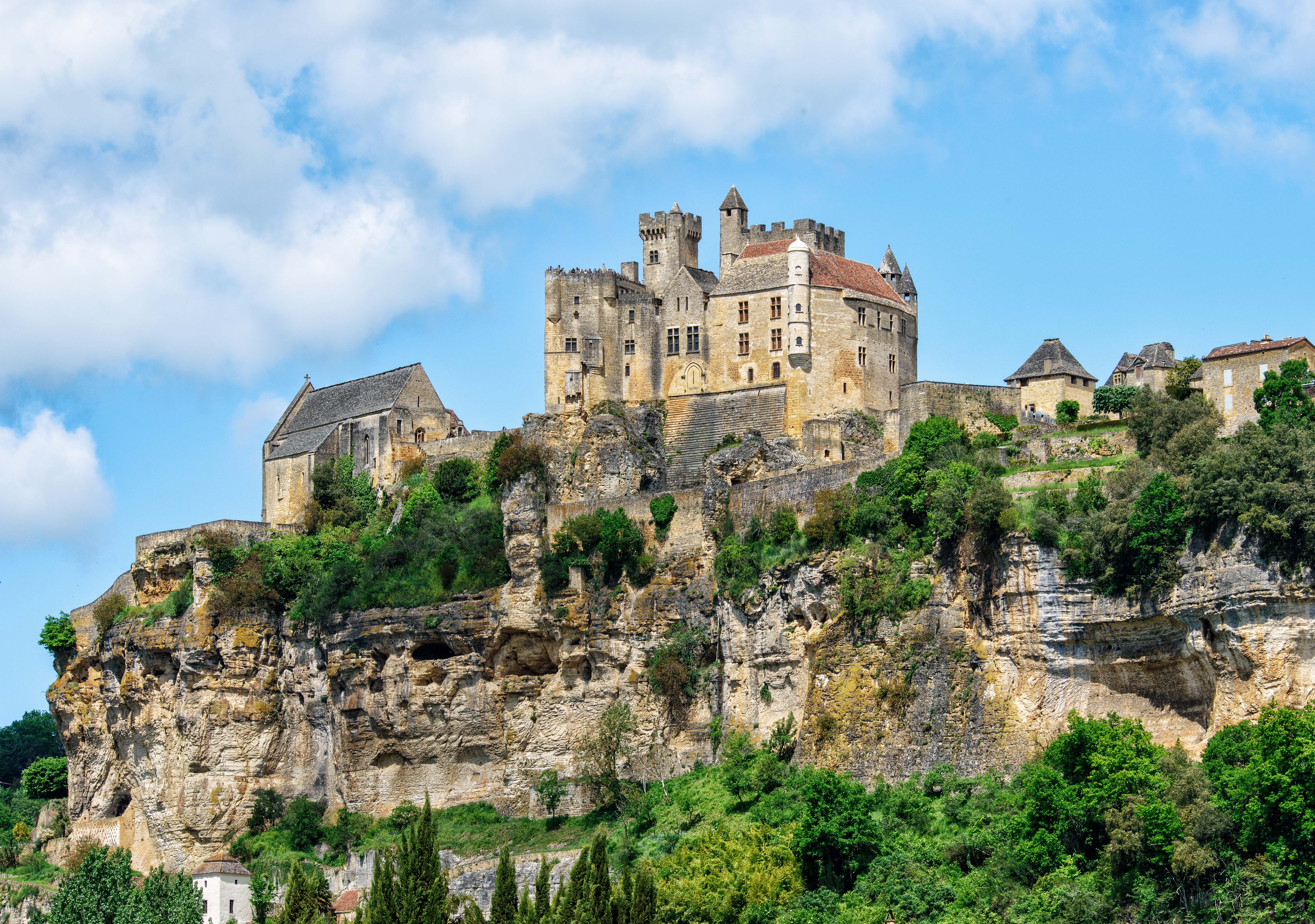
The Château de Beynac
Not far from the Château de Castelnaud is the Château des Milandes. Built during the 15th century, it was more recently the home of the American singer, dancer and actress Josephine Baker who, unable to achieve success in her own country on account of her race, became immensely popular in France:

The Château des Milandes
A short distance upstream from La Roque-Gageac is the village of Domme, perched at the top of a cliff overlooking the Dordogne, also a member of “Les Plus Beaux Villages de France”. At the edge of the cliff, close to the appropriately named restaurant “Le Belvédère,” is a terrace from which there is a spectacular view of the river and its valley:

Valley of the Dordogne
One entrance to Domme is through the imposing Tower Gate, which served as a prison for 70 Knights Templar during the 14th century:

The Tower Gate of Domme
Here are two beautiful medieval buildings found in the Place de la Rode in Domme. The building on the right, built in 1282, which now contains a high quality jewelry shop, was formerly the “maison du batteur de monnaie du Roy Philippe III le Hardi” (“house of the minter of coins of King Philip the Bold”), as one can see from an inscription chiseled into a block of stone on the exterior wall of the building. (Philip the Bold was king of France from 1270 to 1285.) The building on the left is now a restaurant and café called “Le Médiéval.”

In the Place de la Rode, Domme
In Domme, I also purchased some beautiful hand-made pieces of faïence at the boutique “Les Coquelicots.”

As indicated above, kayak and canoe rides on the Dordogne are very popular and offer excellent opportunities for photography. Here is a shot of La Roque-Gageac taken from a canoe on the river:

Kayaking on the Dordogne
The spectacular sights in the Dordogne region are not by any means limited to the banks of the river itself. The area is filled with hundreds of castles and other medieval and Renaissance sights, and in fact is popularly known as the “Land of 1,001 Castles.” One of these is the Château de Puymartin. Built during the 13th century, the castle was destroyed during the Hundred Years War and rebuilt in the 15th century. It has been owned and occupied by descendants of the same family since 1450.

The Château de Puymartin
Nearby is the town of Sarlat-la-Canéda, the principal town in this area. The medieval center of this town has been carefully preserved:

Place de la Liberté, Sarlat-la-Canéda
Sarlat is full of history. The sign on the house shown in this photo states that Etienne La Boétie was born here in 1530. La Boétie was a writer, diplomat, judge and a founder of modern French political philosophy, but is probably best known today as the famous friend of the philosopher Michel de Montaigne.

House of Etienne La Boétie
On Saturdays, there is a large and very popular market in Sarlat:

Market Day in Sarlat
Sarlat’s beauty is not limited to daytime. At night, Sarlat is perhaps the only French town still lit entirely by gas lamps:

Closing Time in Sarlat
Perhaps the strangest of all the castles one can find in the Dordogne region is the Maison Forte de Reignac:
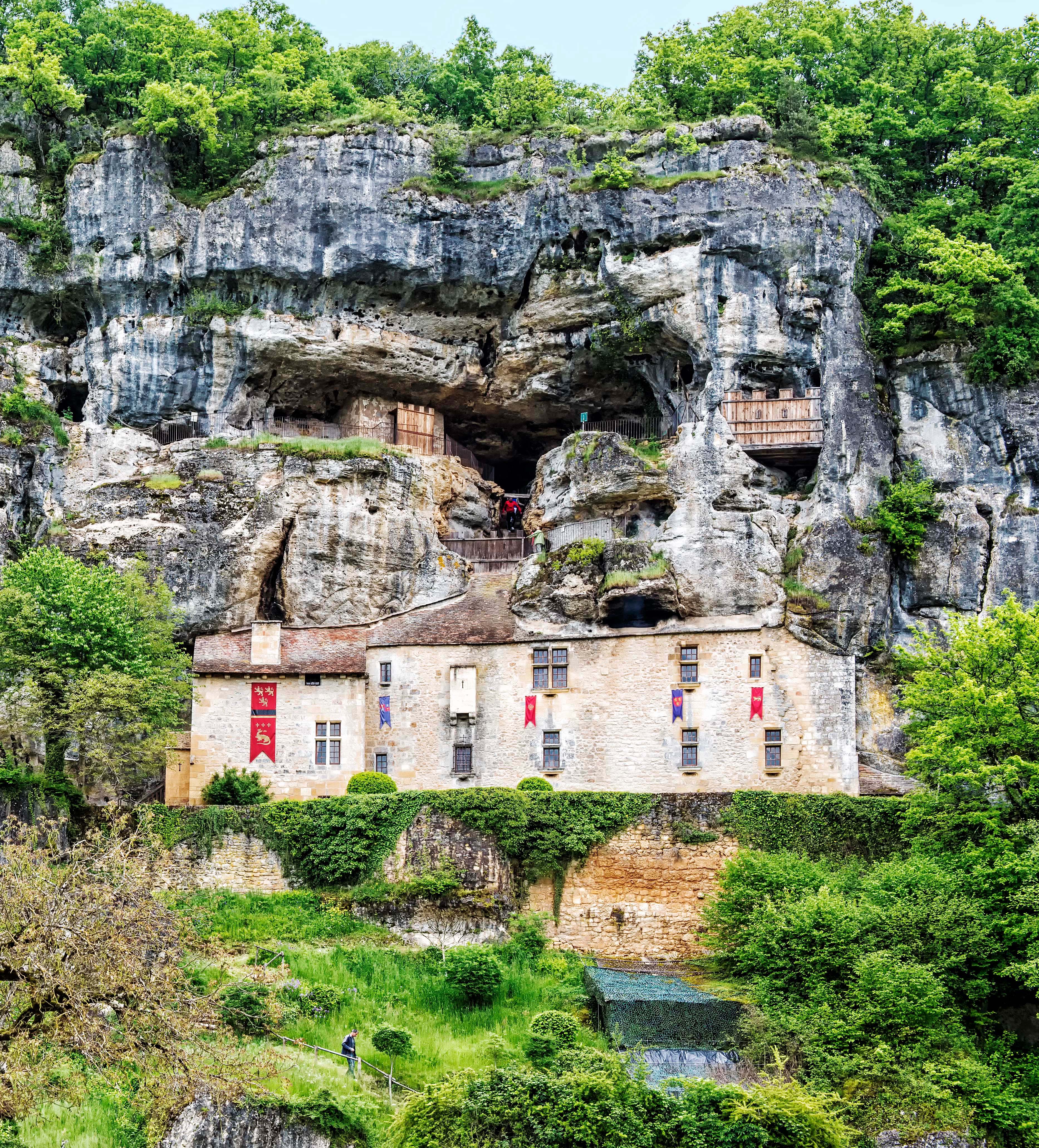
Maison Forte de Reignac
Built into the side of a limestone cliff close to the Vézère River, the façade hides vast interior spaces on multiple levels. Beginning about 700 years ago, it was constructed and occupied as a baronial castle, and its many rooms are today still beautifully outfitted with period furniture and furnishings. But there is also copious evidence that the site was occupied by Cro-Magnon people 20,000 years ago, like many other sites in this area.
A small village not to be missed in this region is Saint-Cyprien. The village is full of beautiful streets such as this one:

Street in Saint-Cyprien
There are also many beautiful façades of houses, such as this one:

Façade of house in Saint-Cyprien
On Sunday mornings, there is a marvelous market in Saint-Cyprien spread out along the Rue Gambetta, the principal street of the town. Here is a colorful olive stall in the market:

Olive stall in the Saint-Cyprien market
Other major attractions in the Dordogne region include Les Eyzies de Tayac, site of the original discovery of Cro-Magnon Man and home today to the Musée National de la Préhistoire (National Museum of Prehistory), and Lascaux II, located in Montignac, a replica of the original Lascaux cave discovered in 1940 which contains the world’s most famous prehistoric cave paintings.
When in the Dordogne, I stay at the idyllic Les Hirondelles (The Swallows), located in the tiny village of Carmensac on Route D48 between Meyrals and Les Eyzies de Tayac. This is a converted and thoroughly modernized 300-year-old stone abbey, owned by an American couple who live in a separate house on the premises. Available on the property for vacation rentals are a one-bedroom “Butterfly Cottage” or the five-bedroom “Mulberry Tree Villa.” The owners have also installed a heated in-ground pool and jacuzzi and other features that help make this a perfect vacation stop. It is centrally located less than 10 minutes from Les Eyzies and about a half hour’s drive from Sarlat-la-Canéda, Beynac-et-Cazenac, Castelnaud-la-Chapelle, La Roque-Gageac, Domme, Lascaux II, Les Milandes, and many other top attractions of the area.

Butterfly Cottage
As you can see, the Dordogne region is filled with an almost inexhaustible supply of beautiful and fascinating things to see and to do. The photos shown in this article and other photos from the Dordogne region are available for viewing and purchase in full original resolution in the Dordogne Gallery of my photography website. For further information about my photography, please also visit my photography Facebook page.
Phil Haber
Copyright © 2015 Philip A. Haber
(Note: An English version of this blog may be found at https://philhaber.com/2013/01/18/a-photographic-tour-of-saint-paul-de-vence.)
Moi et ma femme, nous avons passé une semaine heureuse à Saint-Paul-de-Vence vers la fin d’octobre 2011. Saint-Paul-de-Vence est un village médiéval situé au sommet d’une colline aux contreforts des Alpes maritimes, et environ une demi-heure par voiture au nord-ouest de Nice. Le village est spectaculaire et bien conservé. On peut trouver des mentions du village dans des documents officiels à partir de l’onzième siècle. Le village etait fortifié pour la première fois au treizième siècle, et une deuxième muraille défensive, qui est encore presque entièrement intacte, etait construite pendant le seizième siècle sur la commande du roi François I après une visite royale au village.
Aujourd’hui Saint-Paul est presque entièrement consacré à la création, l’exposition et la vente de l’art moderne. Pendant les mois d’été, le village est plein de touristes, mais vers la fin d’octobre il est beaucoup plus calme. Au fait, au temps de notre arrivée, le fameux hôtel et restaurant La Colombe d’Or, qui est plein de peintures et sculptures des grands artistes du vingtième siècle, était sur le point d’être fermé pour plusieurs mois parce que c’était la fin de la saison. Nous avions voulu retourner à Saint-Paul-de-Vence depuis que, quelques ans plus tôt, nous étions restés au Château du Domaine Saint Martin, qui est situé à Vence, plus haut aux montagnes que Saint-Paul. En allant de Vence à l’aéroport de Nice, nous avions passé Saint-Paul et avions aperçu la vue extraordinaire du village qu’on peut voir depuis la Route de la Colle. J’avais voué qu’un jour j’y retournerais et que je prendrais alors une photo de cette belle vue. Cette fois-ci nous avions décidé à rester à Le Hameau, un charmant hôtel situé sur la Route de la Colle aux environs de Saint-Paul.
Nous sommes arrivés à l’hôtel vers la fin de l’après-midi et, après que je nous y avais enregistrés, j’ai ramassé mon appareil photo et trépied et me suis dirigé à la Route de la Colle. Depuis cette route, il y a une vue inoubliable du côté ouest de Saint-Paul en entier, y compris les murs fortifiés du village. Voici le village, illuminé par des rayons rougeâtres du soleil couchant (vous pouvez cliquer sur n’importe quelle image dans ce blog pour en voir une copie plus grande):

À mon retour à Le Hameau, j’ai erré pendant quelque temps au travers les jardins et passages de ce bel hôtel:
De Le Hameau, on ne mets que 10 minutes pour marcher le long de la Route de la Colle à l’entrée du village de Saint-Paul. Donc je pouvais arriver au village tous les matins avant le lever du soleil pour prendre des photos de ses rues, ses bâtiments et ses cours, tous si beaux et bien préservés, dans la lumière du petit matin et sans piétons et voitures. Après qu’on entre dans le village par son extrémité nord, on passe le restaurant Le Colombe d’Or et puis on entre dans la Rue Grande, qui s’étend sur presque toute la longueur du village du nord au sud, en passant sous des arches anciennes:

Les côtés de la Rue Grande sont parsemés de galeries d’art et d’ateliers d’artistes. Voici des galeries d’art sur la Rue Grande:

Il y a aussi beaucoup d’ateliers d’artistes sur la Rue Grande:

Dans le centre du village, un peu loin de la Rue Grande, se trouve la Place de la Grande Fontaine. Dans le 17ème siècle, cette place était le centre de l’activité sociale et commerciale du village et le site d’un marché hebdomadaire:

Un peu plus loin vers le sud, il y a une cour charmante qui s’appelle “La Placette” et qui contient une petite fontaine:

Un matin, quand je suis arrivé à l’extrémité sud de la Rue Grande, les rayons du soleil levant illuminaient les toits des bâtiments:

Dans ce village, il n’y a pas de manque d’arches médiévaux de pierre:


Depuis les remparts du côté est du village, il y a une vue magnifique des Alpes maritimes au nord:

L’ancien cimetière de Saint Paul est situé à l’extrémité sud du village, en dehors de la muraille. Entre les tombes du cimetière est celle de Marc Chagall, qui habitait au village depuis 1966 jusqu’à sa mort en 1985. Sa tombe est un bloc simple de pierre rectangulaire, dont le dessus est jonché de petites pierres dans l’ancienne tradition juive. Beaucoup de ces pierres portent des hommages au grand maître, écrits à la main.

La population de Saint-Paul comprend moins de trois mille habitants. Avec ses nombreux ateliers, galeries d’art, boutiques, hôtels, églises et restaurants, on pourrait en conclure que le village n’aurait pas beaucoup d’espace pour des habitations. Mais il y a des exemples frappants d’architecture médiévale parmi les maisons qu’on y voit:

Naturellement, il y a beaucoup de bons restaurants à Saint-Paul, y compris le très pittoresque “La Petite Chapelle”:

Vraiment, il y a de belles vues dans presque tous les coins de Saint-Paul:
Comme on peut voir, une visite à Saint-Paul-de-Vence est un impératif pour n’importe quelle personne qui voyage à la Côte d’Azur.
On peut voir et acheter les photos présentées ci-dessus et d’autres photos de Saint-Paul-de-Vence et d’autres villages de la Côte d’Azur à mon site de web photographique, dans la galerie Provence-Côte d’Azur. Pour obtenir plus d’informations sur ma photographie, veuillez visiter aussi ma page photographique de Facebook.
Phil Haber
Copyright © 2013 Philip A. Haber
(Cliquez ici pour lire une traduction de cet article en français: https://philhaber.com/2013/03/29/un-tour-photographique-de-saint-paul-de-vence-version-francaise/.)
My wife and I spent a week in Saint-Paul-de-Vence in late October, 2011. Saint-Paul-de-Vence is a spectacular and well-preserved medieval hill town, located in the foothills of the Maritime Alps, about a half hour’s drive northwest of Nice. It is mentioned in official records as early as the 11th century, and was first fortified in the 13th century. A second defensive wall, still almost entirely intact today, was built in the 16th century, upon the order of King François I following a royal visit to the town.
Today Saint-Paul is almost entirely devoted to the creation, exhibition and sale of modern art. During the summer months, the town is extremely crowded with tourists, but by late October it was much quieter. In fact, at the time we arrived, the famously art-filled restaurant and hotel La Colombe d’Or, located at the northern entrance to the town, was in the process of closing for the season. We had wanted to return to Saint-Paul-de-Vence ever since, some years earlier, we had stayed in the town of Vence — further up in the mountains — and on the way down to the Nice airport had spotted the striking view of Saint-Paul that is visible from the Route de la Colle. I had vowed then that I would some day return and take a photo of that beautiful view of the village. This time we had decided to stay at Le Hameau, a charming hotel on the Route de la Colle just outside Saint-Paul.
We arrived late in the afternoon and, after checking in at Le Hameau, I grabbed my camera and tripod and headed out to the Route de la Colle. From the road, there is an unforgettable view of the entire western side of the village, complete with its fortified walls. Here it is, illuminated by a reddish sun about a half hour before sunset (click on any image in this posting to see a larger version):
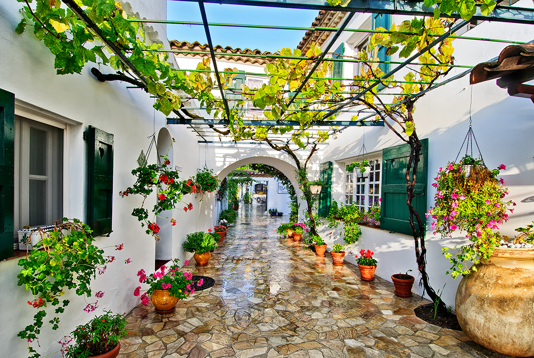
Back at Le Hameau, I took the time to wander through the semi-enclosed outdoor corridors of this beautiful hotel:
From Le Hameau, it was only a 10-minute walk up the Route de la Colle to the entrance to Saint-Paul-de-Vence. I could thus be in the town before dawn every morning to get shots of its beautiful and marvelously preserved streets, buildings and courtyards, at first light and without interference from cars and pedestrians. After entering the town from the north, past La Colombe d’Or, you enter the Rue Grande, which runs nearly the entire length of the village from north to south, passing under centuries-old archways:
The Rue Grande is lined with art galleries and artists’ studios. Here you see art galleries on the Rue Grande:
There are also many artists’ studios on the Rue Grande:
In the center of the village, off the Rue Grande, is the Place de la Grande Fontaine, which was the center of activity and the scene of a weekly market during the 17th century:
A little further to the south is a charming courtyard with a smaller fountain, known as “La Placette”:
One morning, as I reached the southern end of Rue Grande, the rising sun was just illuminating the tops of the buildings:
There is no shortage of medieval stone archways in this village:
From the eastern ramparts of the town, there is a wonderful view of the Maritime Alps to the north:
The old cemetery of Saint Paul lies at the southern end of the town, outside the village walls. Among the tombs one can find that of Marc Chagall, who lived in Saint Paul from 1966 until his death in 1985. The top of the tomb is strewn with small stones in the ancient Jewish tradition, several inscribed with loving tributes to the great master.
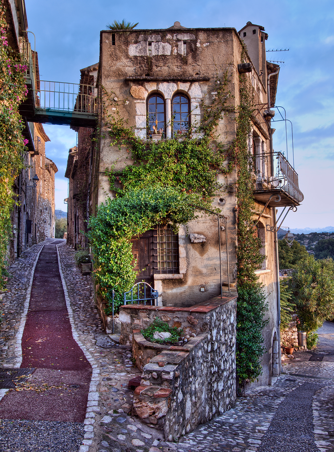
Today, Saint-Paul-de-Vence has a permanent population of only about 3,000. With its many art galleries, studios, shops, hotels and restaurants, the town would not seem to have a lot of room for residences. Yet there are numerous examples of striking medieval architecture in the houses that one does see:
Of course, there are many good restaurants in Saint-Paul, including the very quaint “La Petite Chapelle”:
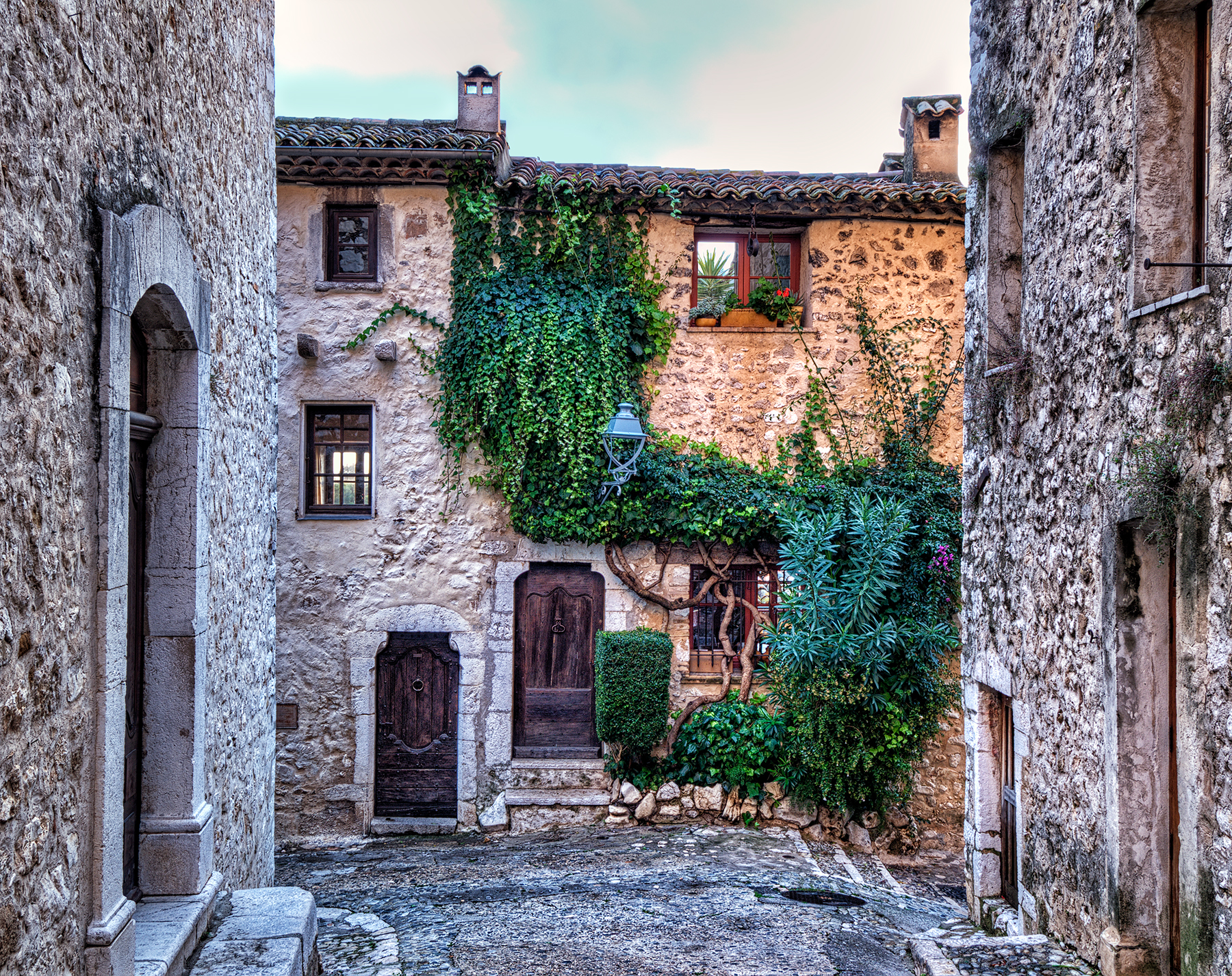
In fact, there is a beautiful sight at just about every corner of the town:
As you can see, a stop in Saint-Paul-de-Vence is a must for anyone visiting the Côte d’Azur.
The photos shown in this article and other photos of Saint-Paul-de-Vence and of other villages in Provence and the Côte d’Azur are available for viewing and purchase in full original resolution on my photo website, in the gallery Provence-Côte d’Azur. For additional information about my photography, please see my photography Facebook page.
Phil Haber
Copyright © 2015 Philip A. Haber

Periodically I have visited the Hawaiian islands of Maui and Kauai, photographing their spectacular landscapes, flora and fauna. Kauai, sometimes referred to as the Garden Isle, is the oldest and furthest northwest of the inhabited Hawaiian islands. The most eroded of these volcanic islands, Kauai features lush vegetation and beautiful mountains, cliffs, waterfalls and beaches, providing ideal nesting sites for many species of birds. Maui, also known as the Valley Isle, is the second youngest of the Hawaiian islands and is located northwest of the big island of Hawaii, from which it is separated by a 26-mile-wide channel. Maui was formed by two volcanoes: the volcano that produced the somewhat eroded West Maui Mountains, and the giant Mount Haleakala, 10,000 feet high and about 30 miles across at its base. The two sections of the island are separated by a flat isthmus, or valley, giving rise to the island’s nickname.
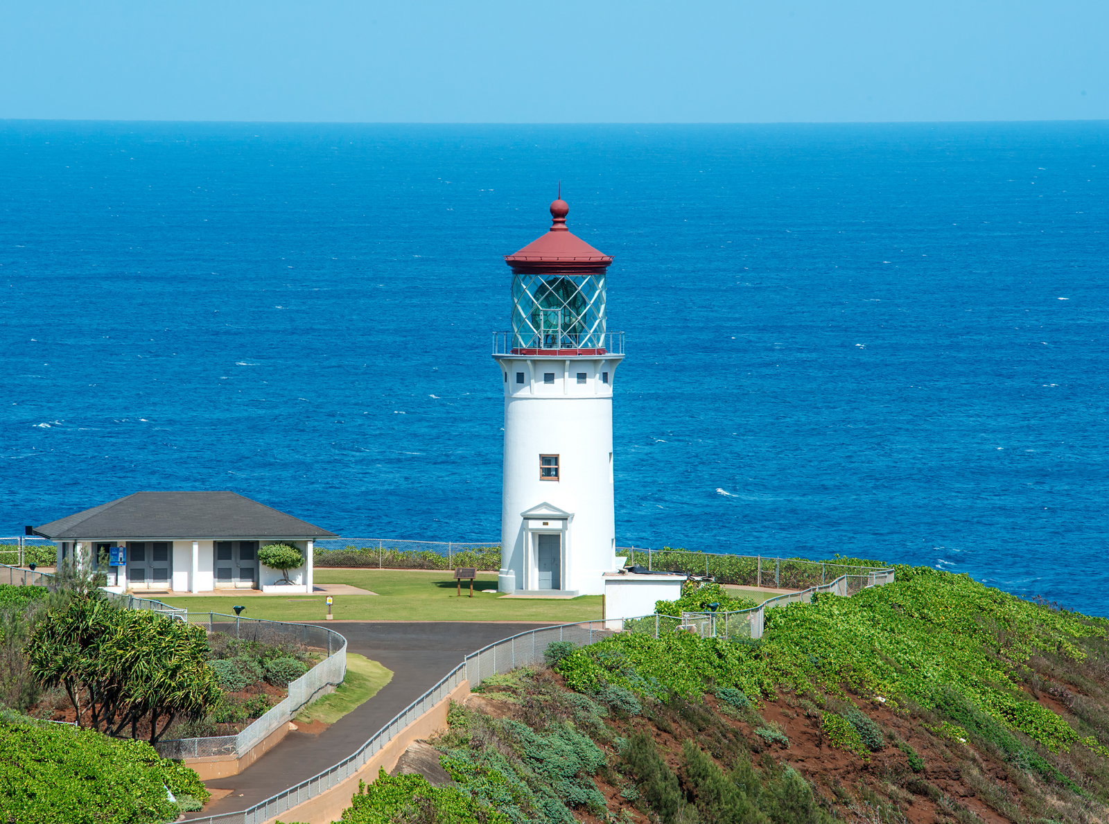
Of particular interest to me are Hawaii’s birds, which include many species that are rarely if ever seen in other parts of the United States. One of the best locations to view such unusual birds is the Kilauea Point National Wildlife Refuge, on the north shore of Kauai several miles east of the resort town of Princeville. Kilauea Point is a 187-foot high promontory that juts out into the Pacific Ocean and is the northernmost point of the inhabited Hawaiian islands. At the end of the promontory sits the Kilauea Point Lighthouse (Note: you may click on any photo in this article to see a larger version):
Looking east from Kilauea Point, you can see rugged cliffs characteristic of the coastline of Kauai, which serve as nesting sites for thousands of large seabirds:

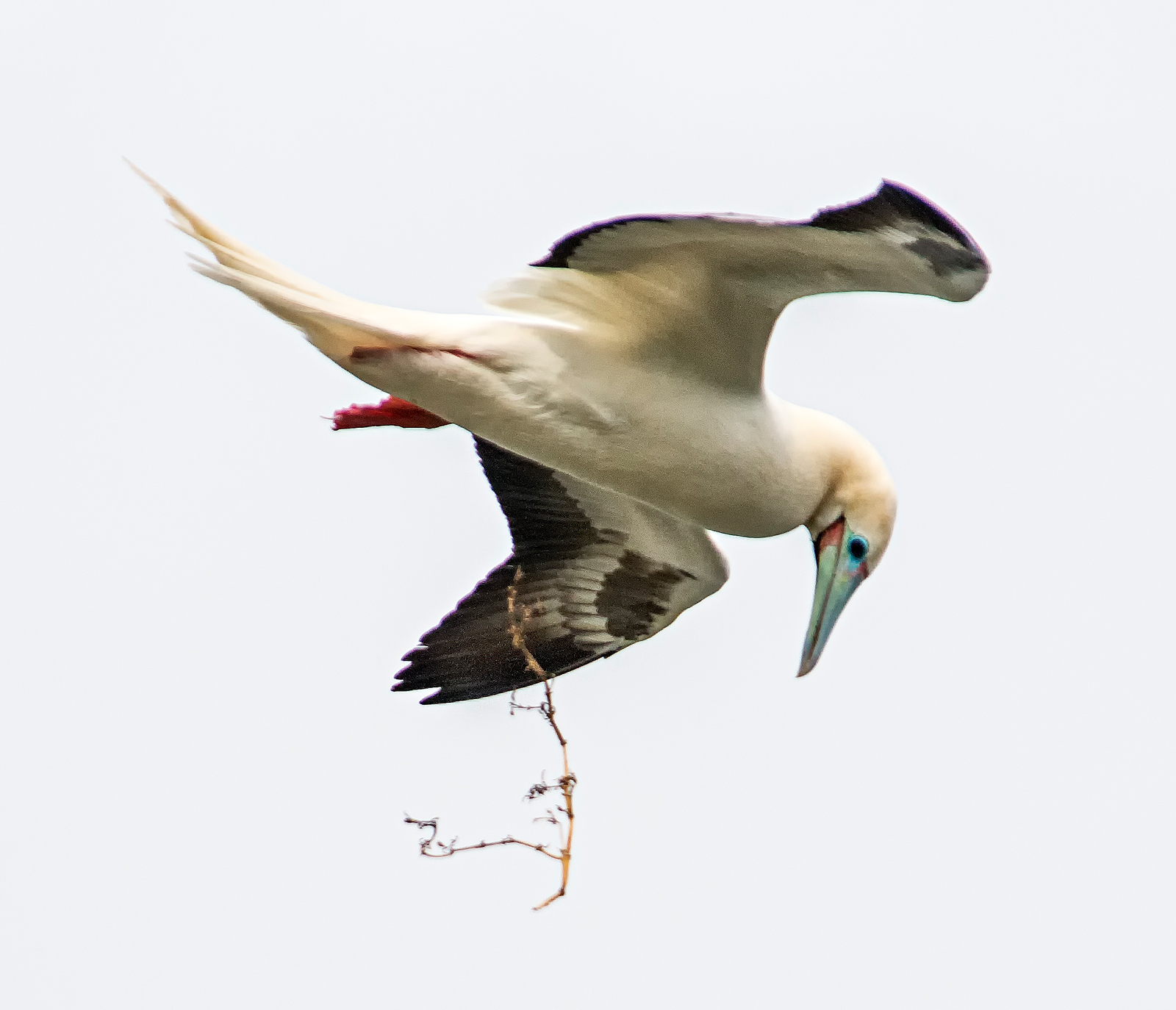
A visit to the Kilauea Point National Wildlife Refuge is an experience not to be missed by any lover of the natural world and its wildlife. The seabirds that can be seen at the refuge include Laysan albatrosses, red-footed boobies, red-tailed and white-tailed tropicbirds, great frigatebirds, and wedge-tailed shearwaters. The most numerous are the red-footed boobies, which nest by the thousands on the neighboring cliffs. At the time of my most recent visit to the refuge in March of 2015, the cliffs were sheltering 1,500 pairs of red-footed boobies, all busy gathering materials to build nests, tearing out pieces of vegetation from the perimeter of Kilauea Point and flying off with them to their nesting sites. Here is a red-footed booby (Sula sula) about to grab an attractive piece of vine:

Up in the sky, they could be seen in full flight with their nest-building materials:

The job of gathering and bringing back nest-building materials is given to the male birds of the species. Their efforts are not always successful:

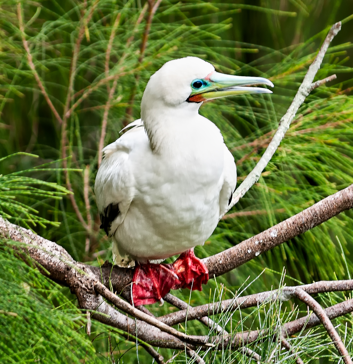
Red-footed boobies were also visible perched in nearby trees — note the distinctive red webbed feet and blue bill:
Here is another shot of a red-footed booby in flight:

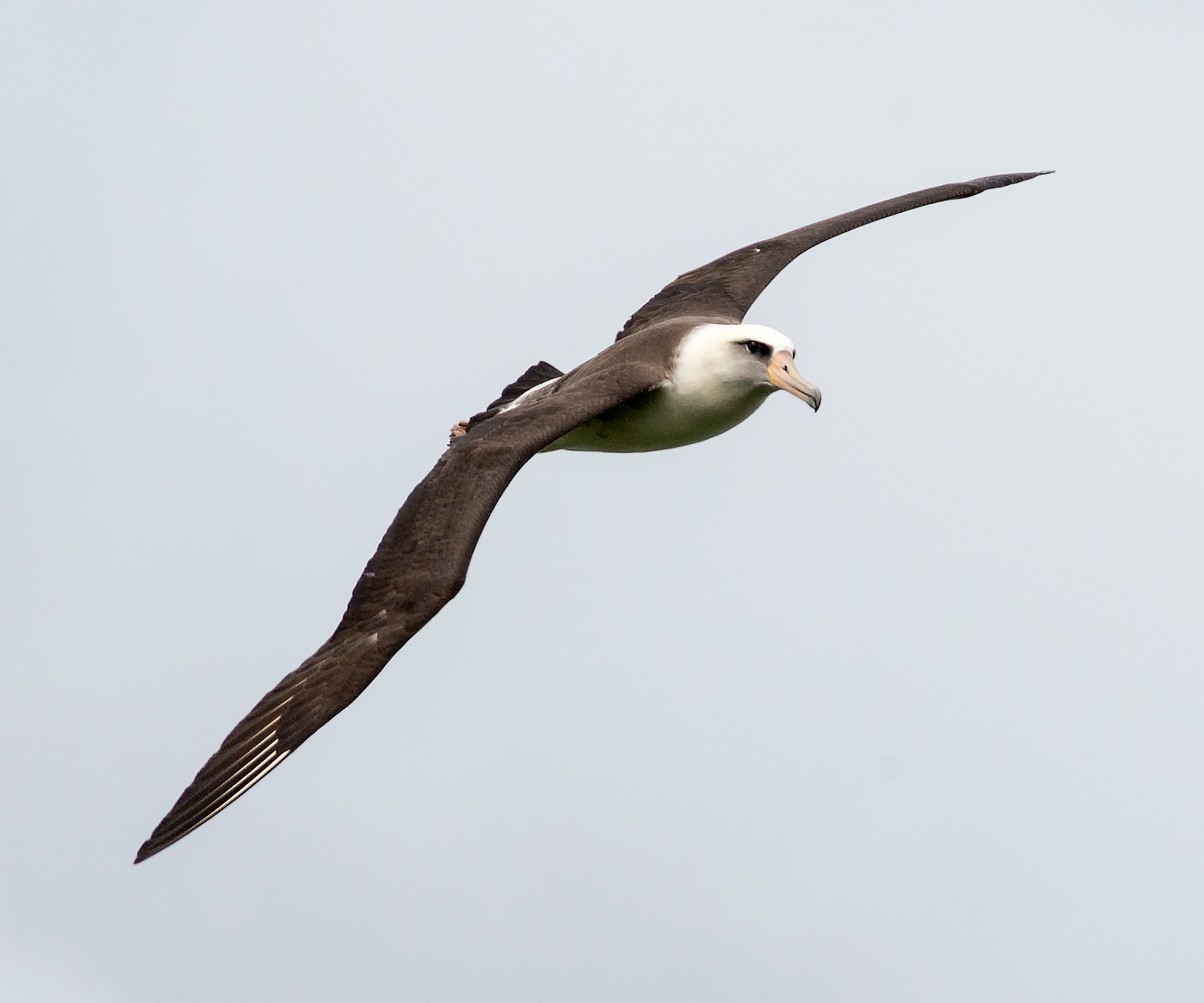
Another seabird often seen flying by at Kilauea Point is the Laysan albatross (Phoebastria immutabilis) (Mōlī, in Hawaiian). These birds have a wingspan of about 6-1/2 feet. Nearly the entire world population of this species lives in the northwest Hawaiian islands:
Hovering overhead in a strong wind were red-tailed tropicbirds (Phaethon rubricauda):

In this shot, I caught a red-tailed tropicbird on a rapid fly-by:
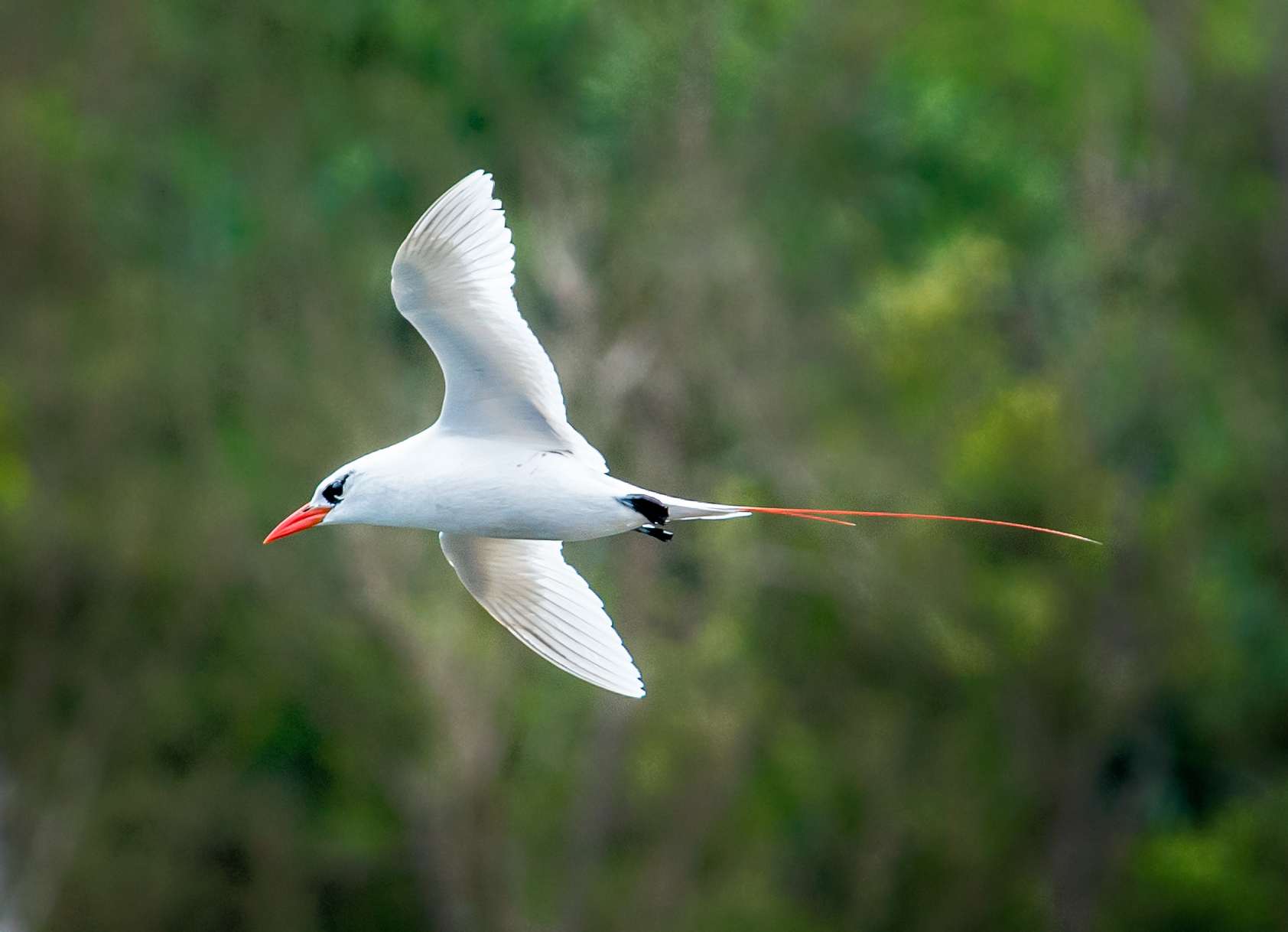
And here is another diving over the ocean:

And here is another resident of the area: a great frigatebird (Fregata minor). These birds have a wingspan of as much as eight feet:

Male great frigatebirds are entirely black except for an inflatable patch of red skin in the throat (known as a gular sac). The females can be distinguished by their white throat and breast, as well as a red eye ring:

Numerous cattle egrets (Bubulcus ibis) may be seen strutting on the ground at the refuge, as well as in many other locations in Hawaii:

Cattle egrets have broad, adaptable diets: primarily insects, plus other invertebrates, fish, frogs, mammals, and birds. Here is one that is about to make a meal out of a gecko it picked out of the top of a hedge in Kihei, Maui:

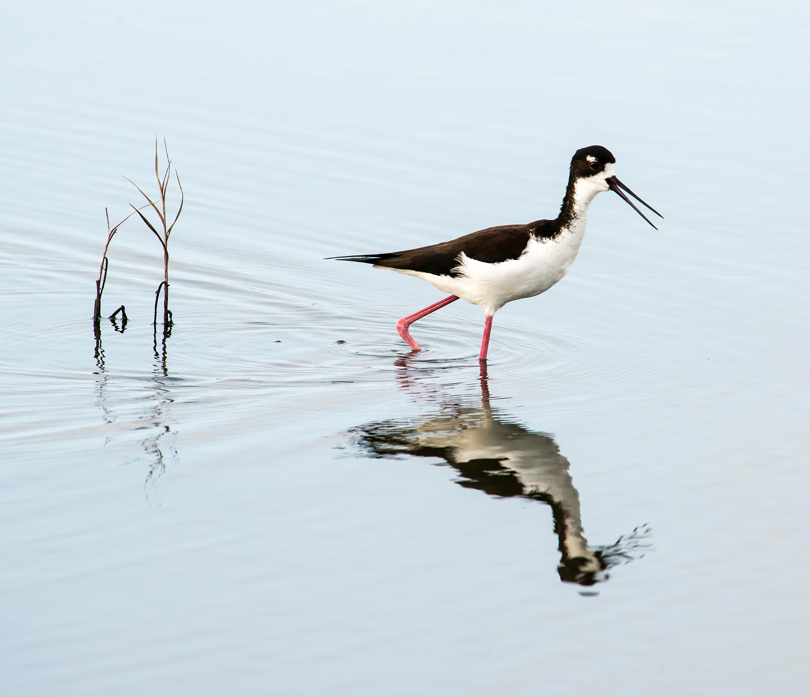
Another good location to see and photograph birds is the Kealia Pond National Wildlife Refuge, located just north of the town of Kihei on Maui. You are sure to find several species of unusual birds there, including the indigenous Hawaiian black-necked stilt (Himantopus mexicanus):
Cattle egrets also abound there:

I don’t mean to suggest that you need to visit a wildlife refuge in order to see birds in Hawaii. Colorful and interesting birds abound just about everywhere in the Hawaiian islands. For example, I found this red-crested cardinal (Paroaria coronata) at the Makena Landing on the southwest coast of Maui:
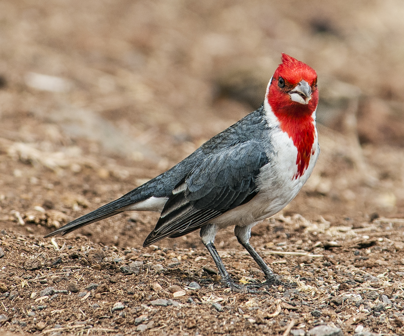
Red-crested cardinals are indigenous to Brazil, Argentina and other parts of South America, and in fact are also known as Brazilian cardinals. They were introduced to Hawaii around 1930 and today are common throughout the Hawaiian islands. Here is one that I found hopping about behind our condo on the north shore of Kauai:
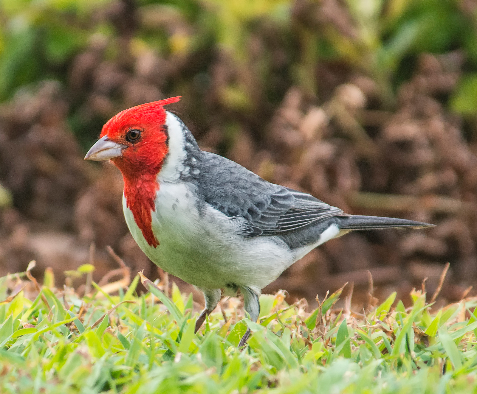
Despite the similarity of names, the red-crested cardinal is not a close relative of the all-red (in the case of the male) northern cardinal (Cardinalis cardinalis), which is found throughout the eastern and southeastern US, southeastern Canada and parts of Mexico. Not only are the two species not members of the same genus (Paroaria vs. Cardinalis), they are not even members of the same family (Thraupidae vs. Cardinalidae).
Laysan albatrosses nest on the ground just about anywhere they choose. Here is a pair that decided to set up house at the edge of the Princeville golf course on the north coast of Kauai:

Always graceful and majestic in flight, Laysan albatrosses can frequently be seen cruising over the north coast of Kauai, near Princeville and Hanalei:

The champion songbird of the islands is clearly the white-rumped shama (Copsychus malabaricus). Native to India and Southeast Asia, these birds were introduced to the island of Kauai from Malaysia in 1931, and later to Oahu. They have a distinctive, complex and beautiful song that is readily recognizable.

The Japanese white-eye (Zosterops japonicus) is a small perching bird that was introduced to Hawaii in 1929 to control insects. Today their numbers throughout the Hawaiian Islands have increased to such an extent that, by consuming a large portion of the available food supply in some areas, they have reportedly become a threat to native Hawaiian species of birds, which have suffered stunted growth and reduced populations.

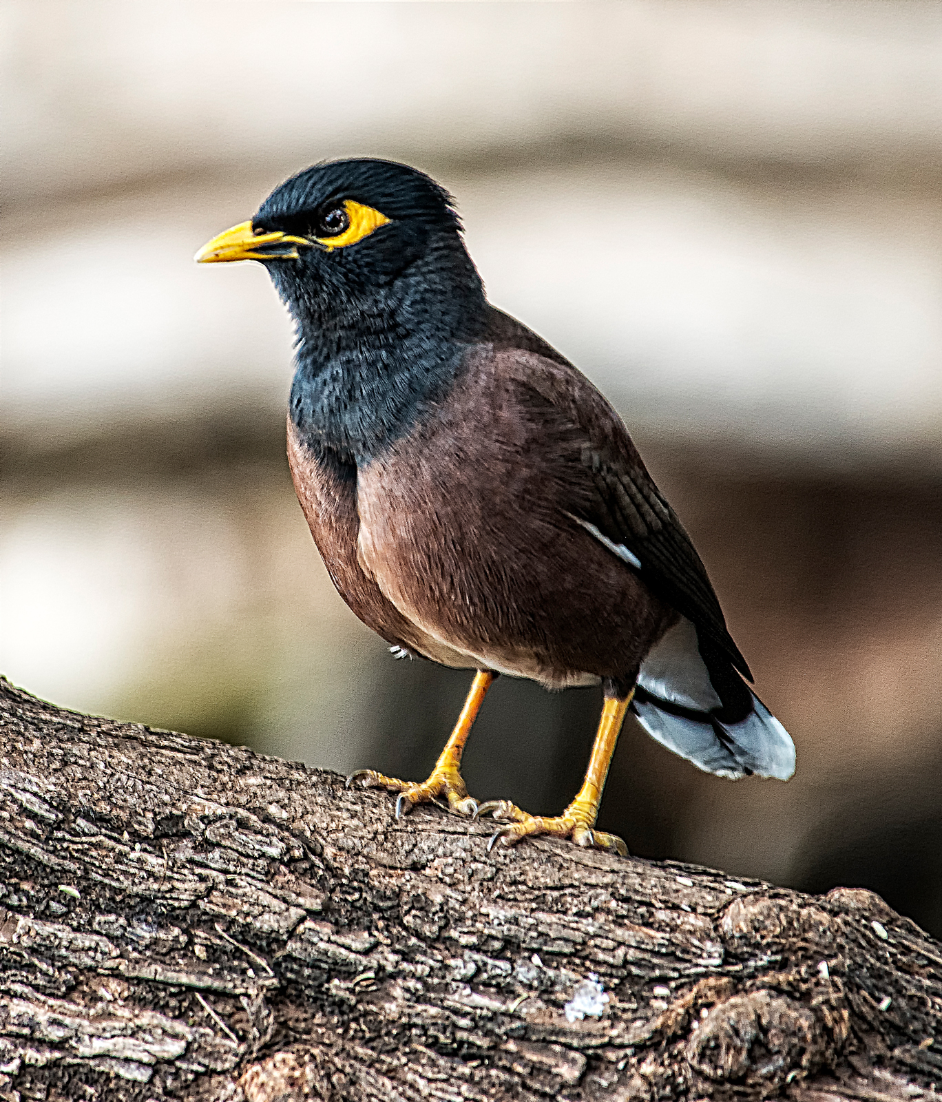
Another non-native bird which is now very common indeed in Hawaii is the common myna (Acridotheres tristis tristis). These birds are native to south Asia and were introduced to Hawaii in 1865 to control an infestation of army worms. They are aggressive, gregarious, noisy and omnivorous, and are widely viewed as an invasive species and a pest.
The spotted dove (Spilopelia chinensis) is commonly seen foraging on the ground throughout the Hawaiian Islands. Originally native to the Indian Subcontinent and Southeast Asia, it was probably introduced to Hawaii from Southeast Asia in the late 1800’s.

Seen below is the Pacific golden plover (Pluvialis fulva), known in Hawaii as the Kolea, in non-breeding plumage. These birds are migratory and spend the summer months (May through August) in Alaska, where they breed. They then fly nonstop to Hawaii, where they spend the winter months. The flight to Hawaii covers about 3,000 miles and takes only about 3 to 4 days. The birds return to Alaska the following summer, for a total round trip distance of some 6,000 miles. How they manage to find their destinations while flying over thousands of miles of open ocean is a mystery.

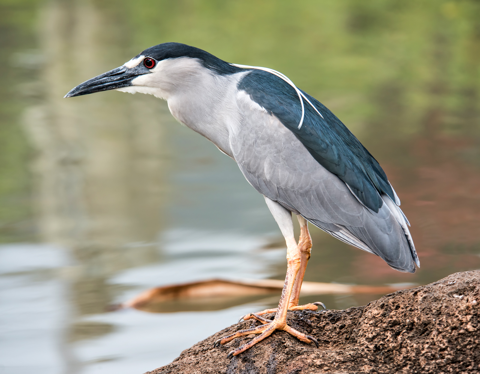
The black-crowned night heron (Nycticorax nycticorax) is commonly seen throughout Hawaii. This one decided to hang out on a pond at The Mill House restaurant, on Maui.
Not to be forgotten is the nene, or native Hawaiian goose (Branta sandvicensis), which is the official state bird of Hawaii:
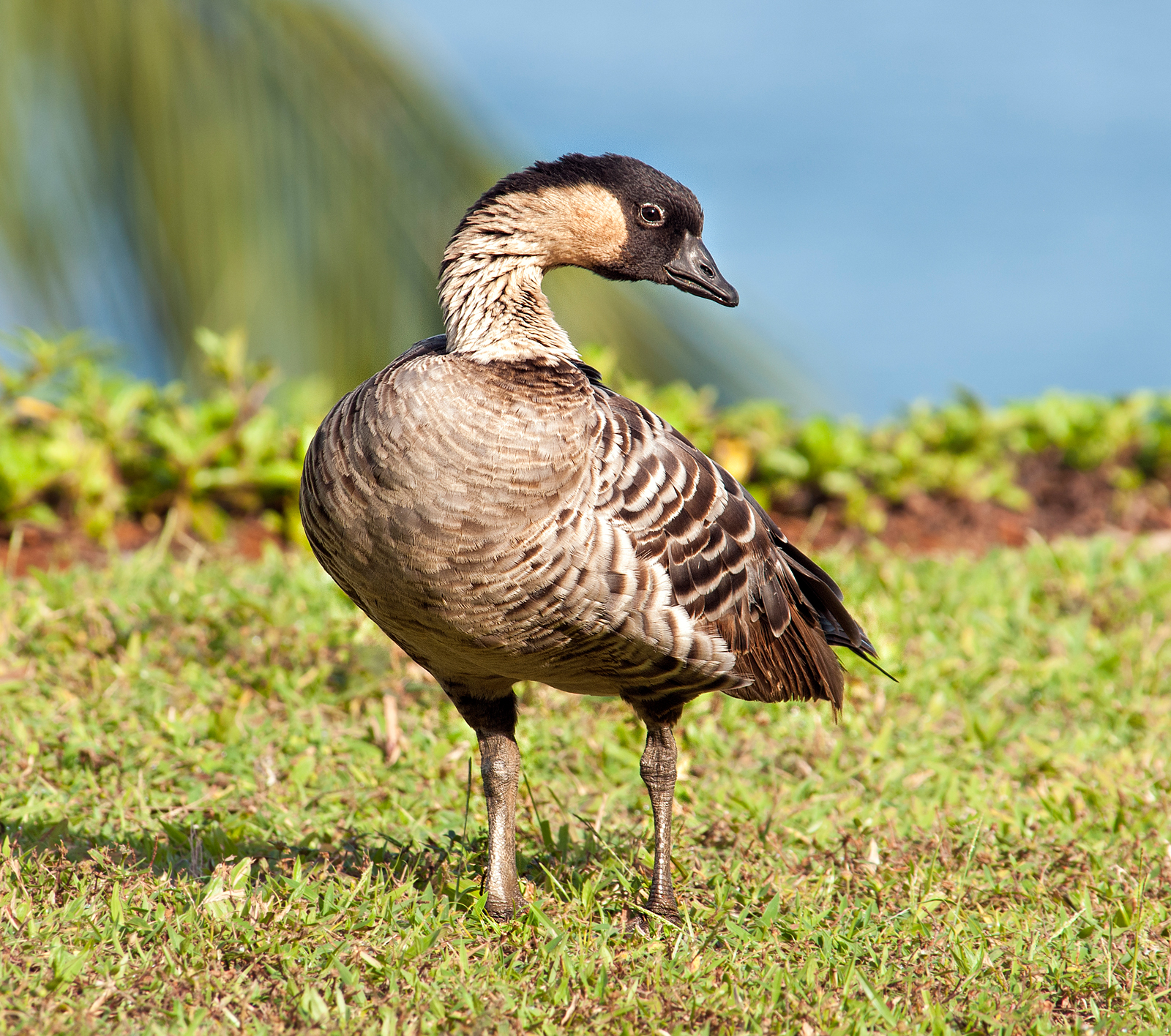
Like many other native Hawaiian species of birds, the nene is listed as endangered, a consequence of loss of habitat and competition for limited resources from imported invasive species of birds, including some of those described above.
These photos present just a small sample of the wonders available for viewing at the Kilauea Point National Wildlife Refuge, the Kealia Pond National Wildlife Refuge, and other locations throughout the Hawaiian islands. Apart from the amazing birds, you may also spot breaching humpback whales, bottlenose dolphins, green sea turtles, and rare monk seals (only 1,200 left on earth).
Other photos of Hawaii’s birds, as well as landscapes and other Hawaiian sights, may be seen in the Birds of Hawaii Gallery and the Hawaii Gallery on my photo website. For additional information about my photography, please see my photography Facebook page.
Phil Haber
Copyright © 2015 Philip A. Haber
One of the goals of my month spent in Provence and the Côte d’Azur during October, 2011 was to visit and photograph sites that were important to the life and work of Vincent van Gogh. Van Gogh is today, of course, one of the most admired artists of the late nineteenth century. His art and his tortured life are the subject of a large number of books, articles and films, including Irving Stone’s 1934 biographical novel, “Lust for Life,” the 1956 movie of the same name based on the novel, and, most recently, an exhaustively detailed biography, “Van Gogh, The Life,” by Steven Naifeh and Gregory White Smith (Random House, October 2011). Despite the fact that van Gogh’s artistic career spanned only a little more than ten years, his output was prodigious, comprising about 2,000 paintings, drawings and other works. He is most celebrated for the landscapes, portraits and still lifes he completed during the last five years of his life. These include “The Starry Night,” paintings of sunflowers and other flowers, trees and gardens, self-portraits, and portraits of “L’Arlésienne” (Madame Ginoux), of the postman Joseph Roulin and his wife, of Dr. Paul Gachet, and of other persons with whom he came in contact during these years.
Throughout his life, van Gogh suffered from serious mental and physical illnesses, including a form of epilepsy (as diagnosed by doctors at the time) and syphilis. He also suffered from an extremely excitable, irascible and seemingly bipolar personality that put him constantly at odds with nearly everyone with whom he came in contact, including his parents and other family members, employers and business associates, fellow artists and members of any community he inhabited. During his lifetime he sold only one painting, despite his younger brother Theo’s position as a mid-level manager at one of Europe’s most prominent art dealers. Theo in fact supported him financially during his entire career as an artist. His work was generally considered unsalable and received little notice until the publication in January 1890 (about six months before his death) of a highly favorable article in the magazine Mercure de France by the young critic Albert Aurier. Van Gogh’s late work has been variously characterized as Post-Impressionist, Symbolist and Cloisonnist, but remains distinctly recognizable as his own unique style.
In February, 1888, after living with his brother in Paris for two years, van Gogh moved to Arles and eventually established his residence and a studio there in the famous “Yellow House” at 2, Place Lamartine (unfortunately destroyed in a bombing raid during World War II). The period of van Gogh’s residence in Arles, from February, 1888 until May, 1889, saw the creation of many of his most well-known paintings. The Office of Tourism in Arles offers a free map of the city showing the locations where ten of these paintings were done. At each of these locations, a reproduction of the work painted there is set up on a post at approximately the location where van Gogh is thought to have stood as he painted. Of course, some of the locations van Gogh painted no longer exist, such as the Yellow House, or look quite different today than they did when he painted them more than 120 years ago. However, several are still quite recognizable. My first stop after arriving in Arles was at the site of van Gogh’s 1888 oil painting, “The Café Terrace on the Place du Forum, at Night.” This is the van Gogh painting:

The Café Terrace on the Place du Forum, 1888, oil on canvas
Here is my photo of this location as it looks today, during the daytime, from approximately the same perspective:

In October, 1888, van Gogh painted this image of the entrance to the Trinquetaille Bridge, which spans the Rhone River at Arles:

The Trinquetaille Bridge, 1888, oil on canvas
Here is that location as it appears today:

One must admit that the appearance of this site is not improved by the addition of a parked car, graffiti and trash bin.
After months of entreaties from van Gogh, the artist Paul Gauguin joined him at the Yellow House in late October, 1888, and the two spent several weeks living and working together. It had long been a dream of van Gogh to form an artistic movement with Gauguin and other artists he hoped to attract to Arles. However, his relationships with other artists frequently ended with violent disagreements, and Gauguin was no exception. After a number of clashes between them, Gauguin walked out of the Yellow House on December 23. Apparently thinking that Gauguin was leaving for good, van Gogh initially ran after him. According to some accounts, van Gogh threatened Gauguin in a park with a straight razor, but Naifeh and Smith state (p. 702) that he simply gave Gauguin a newspaper article containing the words “Le meurtrier a pris la fuite” (the murderer has fled). In any event, it is undisputed that, when van Gogh returned to the Yellow House, he had an attack of some sort, cut off part of his ear with a razor, wrapped the severed flesh in a piece of newspaper and delivered it to a nearby brothel with instructions to give it to a prostitute named Rachel. There followed several months during which van Gogh alternated between a hospital in Arles and the Yellow House, until the police, upon the petition of about 30 neighbors, padlocked the door of the Yellow House in order to prevent him from returning there.
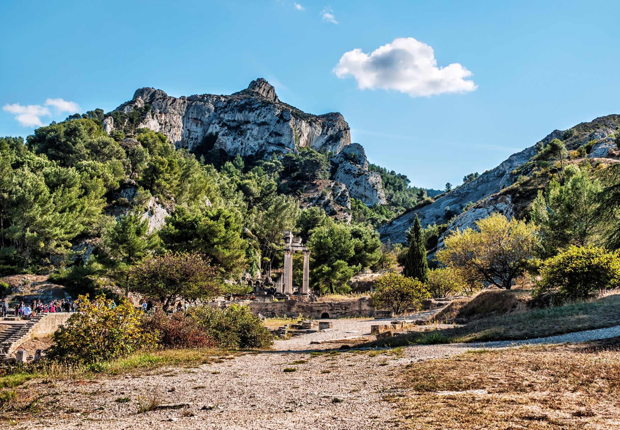
In May, 1889, van Gogh voluntarily committed himself to the asylum of Saint Paul de Mausole, located about a mile south of Saint Rémy-de-Provence at the base of the Alpilles mountain range. The asylum, a former monastery, derives its name from the nearby Mausoleum of the Julii, built about 30 BC by three Julii brothers in honor of their father, who had been granted Roman citizenship and the right to use the name “Julii” in return for his military or civil service to Rome. The mausoleum today remains in remarkably good condition:

Between the Mausoleum and the asylum lies the ancient Gallo-Roman town of Glanum, which has been under excavation since 1921. From the grounds of that site, I took this photo of the Mont Gaussier, which is part of the Alpilles range:
During his more lucid moments, van Gogh was permitted to leave the grounds of the asylum to paint. In a number of his paintings of that period, the above landscape is clearly visible, for example:

Le Mont Gaussier with the Mas de Saint Paul, 1889, oil on canvas

A Meadow in the Mountains, 1889, oil on canvas

Mountains at Saint Rémy with Dark Cottage, 1889, oil on canvas

Olive Trees in a Mountainous Landscape, 1889, oil on canvas
The Alpilles also appear in the background of van Gogh’s most famous painting, “The Starry Night,” likewise painted during this period. Regrettably, the wheat fields and olive groves so beautifully painted by van Gogh during his stay at Saint Paul de Mausole have since fallen victim to extensive residential construction in the vicinity of Saint Rémy.
As is generally known, Van Gogh died of a gunshot wound in the abdomen in July, 1890, while living in Auvers-sur-Oise under the care of Dr. Gachet. While popular accounts have attributed his death to suicide, Naifeh and Smith present substantial evidence that the shot may have been fired by someone else, possibly accidentally. See “Appendix: A Note on Vincent’s Fatal Wounding,” pp. 869 et seq.
Please note that the photographs shown in this posting are low resolution copies of the originals. For full resolution copies of these and other photos of Arles, Saint Rémy-de-Provence and other towns and villages in Provence, please visit the gallery Provence-Côte d’Azur on my photography website, Phil Haber Photography, where signed prints of these photos may be purchased. For additional information about my photography, please see my photography Facebook page.
Phil Haber
Copyright © 2012 Philip A. Haber
(Cliquez ici pour lire une traduction de cet article en français: https://philhaber.com/2013/11/19/un-tour-photographique-de-roussillon-version-francaise/.)
During the month my wife and I spent in Provence and the Côte d’Azur, in October of 2011, we set aside a day to visit the spectacular hill town of Roussillon. Roussillon lies in the heart of the region known as the Luberon, a large and mountainous area to the north of Aix-en-Provence which occupies a part of the department of the Vaucluse. The drive to Roussillon from Aix, where we had rented an apartment, is about 40 miles but can take well over an hour even by the most direct route. The narrow roads wind around hills and through picturesque valleys, running past or through other hill towns such as Bonnieux and Lourmarin, which are themselves eminently worthy of a stop or a day trip.
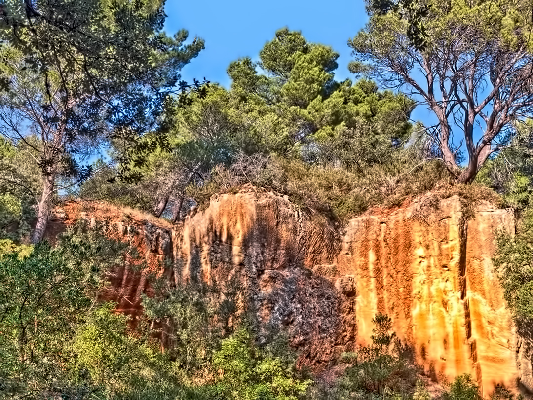
Roussillon sits on massive deposits of red, orange and yellow ochre. The colors of the ochre result from the presence of large quantities of hydrated and anhydrous iron oxides which were deposited over 100 million years ago when the land that is now Provence was part of the seabed. One of the first sights which the traveller sees upon entering Roussillon is a large ochre cliff immediately opposite the eastern side of the town (click on any photo in this posting to see a larger version):

A short walk from the town up the hill along the top of this cliff brings you to the ochre quarries, where for centuries the colorful building materials from which the town was constructed were obtained. In the quarries are many colorful and fanciful stone shapes such as these:

From the top of the cliff there is a striking view of the town:
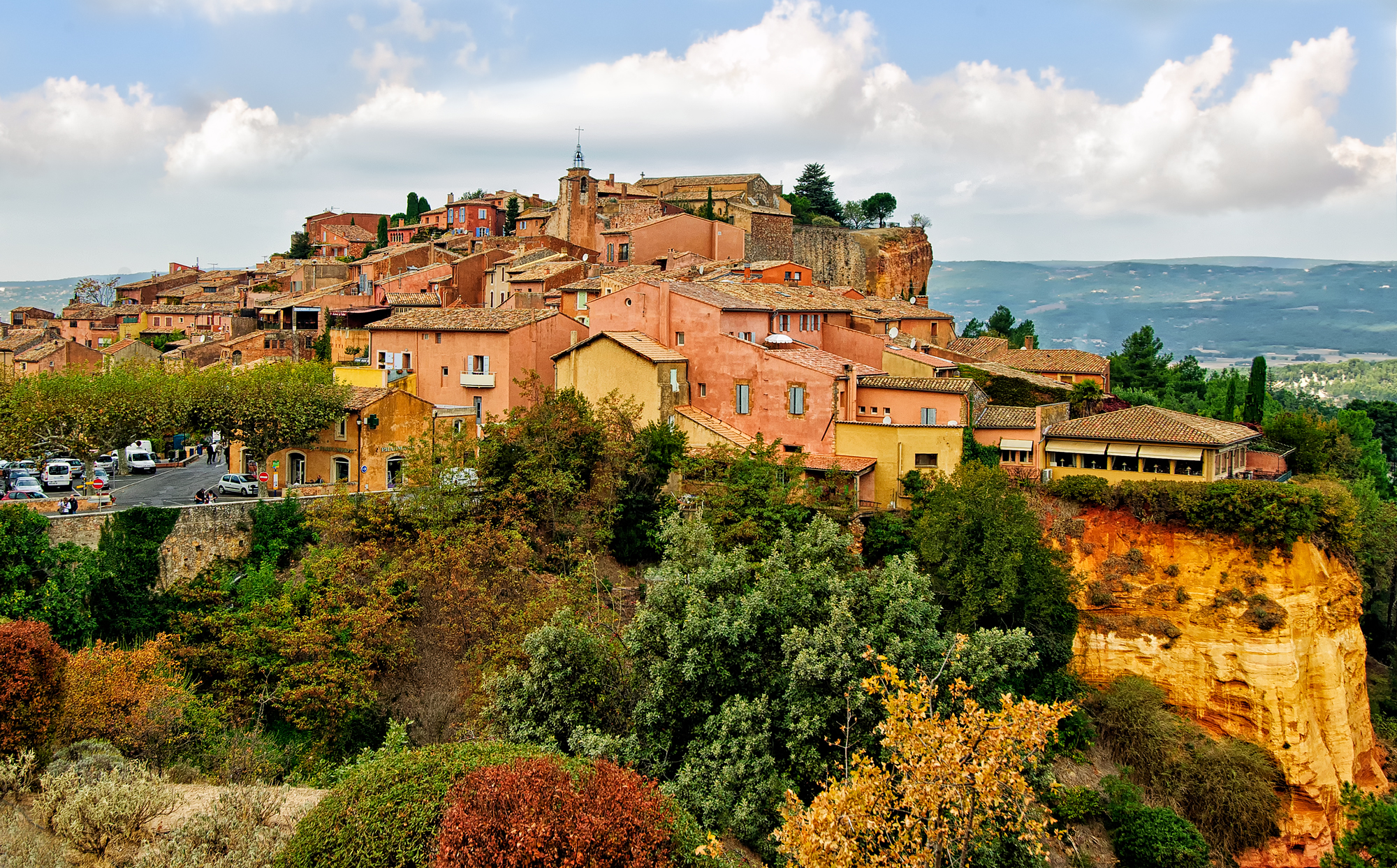
Inside the town itself, the red, orange and yellow colors of the ochre dominate:

As in so many towns in Provence, there is a beautiful clock tower, made in this case of the same red ochre materials one sees elsewhere in Roussillon:

I couldn’t resist taking a photo through the archway in the clock tower from the other side:

Every street in the town bears witness to the ubiquitous ochre materials:

Doors, windows and shutters are also strikingly colored to match or contrast with the prevailing ochre colors of the walls:


It does not take long to see why this town is included in the official list of Les Plus Beaux Villages de France (The Most Beautiful Villages of France). A visit to Roussillon is an unforgettable experience.
The photos shown in this article and other photos of Roussillon and of other towns and villages in Provence and the Côte d’Azur are available for viewing and purchase in full original resolution in the gallery Provence-Côte d’Azur on my photography website, Phil Haber Photography. For additional information about my photography, please see my photography Facebook page.
Phil Haber
Copyright © 2013 Philip A. Haber
(Cliquez ici pour lire une traduction de cet article en français: https://philhaber.com/2015/04/17/dans-les-pas-de-cezanne-iiieme-partie-les-carrieres-de-bibemus-version-francaisee/.)
My third and last of the Cézanne tours organized by the Office de Tourisme of Aix-en-Provence involved a visit to the Bibémus quarries (carrières de Bibémus), a site where Cézanne painted frequently from 1895 to 1904. The quarries are located a few miles east of the center of Aix. These quarries had been in operation at least since the days of the Roman empire, and were extensively worked during the 17th and 18th centuries. The reddish-yellow ochre rocks obtained there were used in the construction of buildings and monuments in Aix and elsewhere. But after the 18th century, the quarries fell into disuse because of fissures and sand pockets in the quarries’ rocks, probably resulting from the presence of high levels of salt, which also made sand quarried there useless as a component of concrete. In 1885, the quarries were closed and thereafter were completely abandoned, which allowed Cézanne to work there whenever he wished. In 1954, a portion of the quarry site was purchased by the American artist George Bunker, who upon his death in 1991 left it to the city of Aix-en-Provence, on condition that it not be commercially developed but maintained as a public park in memory of Cézanne. The city opened the quarries to the public, along with the other Cézanne tour sites, during the centennial of Cézanne’s death in 2006.
While painting in the quarries, Cézanne rented a stone cabin (“cabanon”) located there in order to avoid having to travel daily to and from Aix with his paints, brushes and supplies. The cabin is still there today (click on any picture in this posting to see a larger version):

Cézanne’s Cabanon in the Bibémus Quarries
The quarries were an ideal subject for Cézanne’s style of painting, lending themselves naturally to representation as a collection of geometrical shapes of contrasting colors. Here are some examples:

Bibémus Quarry, 1895, oil on canvas

Corner of Quarry, 1900-02, oil on canvas
While there has been extensive growth of vegetation in the quarries in the more than 100 years since Cézanne painted there, much of this unusual landscape is still visible today:
The Bibemus Quarry
At several points during the tour, a panel with a reproduction of one of Cézanne’s paintings in the quarries is set up at the exact spot where he painted. Thus one can compare the painting itself, e.g. —

Bibémus: The Red Rock, c. 1897, oil on canvas
with the same view as it currently appears:

The Red Rock
One of Cézanne’s most well-known paintings shows Mont Sainte-Victoire in an apparent view from the Bibémus quarries, with the red and yellow rocks of the quarries seen directly below and in front of the mountain:

Mont Sainte-Victoire Seen from the Bibémus Quarries, c. 1897, oil on canvas
Interestingly, this view cannot be found in the quarries. While Mont Sainte-Victoire is in fact visible from certain parts of the quarries, the ochre rocks are nowhere to be seen in those views. For example, I saw this view of the mountain during the tour:

View of Mont Sainte-Victoire from the Bibemus Quarries
According to our tour guide, the view painted by Cézanne never actually existed even in Cézanne’s day, and Cézanne simply created a composite picture showing the mountain together with rocks that were visible only from a different part of the quarry. Of course, as a painter Cézanne could take such liberties. Such a scene might seem difficult for a photographer to emulate. However, with today’s digital photography and such tools as Photoshop, a similar photographic representation can be easily created:

This combination photograph is composed of parts of two of my other photos shown in this posting, i.e. those entitled “The Bibémus Quarry” and “View of Mont Sainte-Victoire from the Bibémus Quarries.” Its remarkable similarity to Cézanne’s 1897 painting suggests the possibility that Cézanne’s painting may in fact be a combined representation of these two views taken from different parts of the quarries.
The three tours “Dans les Pas de Cézanne” organized by the Office de Tourisme of Aix-en-Provence were certainly among the most interesting and informative of the many activities and sights afforded by this remarkable destination. They are an experience not to be missed, especially for lovers of modern art.
For additional photos of Aix-en-Provence and other beautiful and interesting cities and villages in Provence and the Côte d’Azur, please visit the gallery Provence-Côte d’Azur on my photography website, Phil Haber Photography. For additional information about my photography, please see my photography Facebook page.
Phil Haber
Copyright © 2011 Philip A. Haber
(Cliquez ici pour lire une traduction de cet article en français: https://philhaber.com/2015/04/16/dans-les-pas-de-cezanne-iieme-partie-latelier-a-les-lauves-et-mont-sainte-victoire-version-francaise/.)
After the Cézanne family estate at the Jas de Bouffan was sold in 1899, Cézanne needed a new studio in which to work and to store his unfinished canvases, paints and other working materials. In 1901, he bought a plot of land in an area known as Les Lauves, which in Cézanne’s day was open countryside to the north of Aix-en-Provence, and is now a built-up suburb. This was Cézanne’s last studio, and he designed it with great care. It includes a ground floor with living accommodations, and a first floor studio with a very high ceiling, the necessary large window facing north for good lighting, and windows facing south toward the town. The studio is located on a road that at the time was called the Chemin des Lauves and is now named Avenue Paul Cézanne (although it is still called Chemin des Lauves beginning at a point further north). Cézanne worked in this studio from 1902 until his death in 1906, and here painted his final masterpieces, including the large bathers series, numerous still lifes, and many paintings of Mont Sainte-Victoire (although the latter were often painted on location). While today there are no paintings remaining in the studio, there are many recognizable articles from Cézanne’s last years, including a huge easel, a ladder, brushes and palettes, and various objects that appear in his still lifes, such as a table, numerous pots, jugs and bowls, three skulls and a plaster cast of a cupid. Photographs inside the studio were unfortunately not permitted to be taken.
At the time that the studio at Les Lauves was built, Mont Sainte-Victoire was visible from there. Today, construction and the growth of trees and other vegetation in the surrounding area have blocked the view of Mont Sainte-Victoire from the studio. However, in any event Cézanne preferred the much better view that was available on higher ground about a half mile further north. That location still exists today — a small public park named “Terrain des Peintres” has been set aside by the town of Aix-en-Provence at the location where Cézanne created his last paintings of the mountain, a few dozen steps above the road. An open space is provided, surrounded by ten panels containing reproductions of paintings of the mountain by Cézanne from that site. The view to the east from there is nothing less than spectacular (click on any picture in this post for a larger view):

Mont Sainte-Victoire from Les Lauves
The photo above shows the view of the mountain that appears in Cézanne’s many paintings of it from this location, such as these:

Mont Sainte-Victoire, 1902-04, oil on canvas

Mont Sainte-Victoire vu des Lauves, 1904-06, oil on canvas
These “Post-Impressionist” paintings exhibit the characteristics of Cézanne’s mature work that so inspired the Cubists, Fauvists and other modern artists: objects, including the mountain, trees, buildings and even the sky and clouds are represented by geometric shapes arranged in patterns of color gradations. The illusion of depth is created by careful use of lines and contrasting patches of color. Note also that, particularly in the case of the first of the above paintings, the vertical perspective is not natural but has been altered to emphasize the shapes and characteristics of the mountain and the intervening space. Such alterations of perspective were characteristic of Cézanne’s still lifes, as well as his landscapes – see the introductory commentary in Cézanne, by the great art historian Meyer Schapiro (Harry N. Abrams, Inc., New York, 1952).
As mentioned in a previous posting in this series, during his lifetime Cézanne painted the Mont Sainte-Victoire no less than 87 times. While Cézanne favored the site at Les Lauves during the last years of his life, he had earlier painted the mountain from a considerable variety of other locations. Another of his favorite viewpoints was from the vicinity of Le Tholonet, a small village lying about four miles east of Aix-en-Provence, along a road known in Cézanne’s day as the Route du Tholonet and now called the Route de Cézanne. In this area, there are wonderful views of the mountain from the southwest, as opposed to the view from straight west seen at Les Lauves. This is one of Cézanne’s paintings of Mont Sainte-Victoire from a viewpoint near the Route du Tholonet:

Mont Sainte-Victoire Above the Route du Tholonet, c. 1900, oil on canvas
In search of a similar viewpoint, I drove east along the road from Aix, and a little past Le Tholonet came upon a park on the north side of the road with a hiking trail up a steep hillside, from which there was an excellent view of the mountain:

Mont Sainte-Victoire from near Le Tholonet
While Cézanne’s work was apparently not well received by the citizens of his home town during his lifetime – see the article Paul Cézanne in Wikipedia – today it is difficult to go anywhere in or around Aix without seeing references to him in the form of statues, plaques, street names and other memorials, e.g.:

Statue of Cézanne at La Rotonde, Aix-en-Provence
Indeed, Cézanne’s presence seems to dominate the city from the Office de Tourisme at its center to its outermost parts, and yet is only one facet of a town that has an enormous quantity of wondrous things to offer the visitor. For other photos of Aix-en-Provence and other beautiful and interesting cities and villages in Provence and the Côte d’Azur, please visit the gallery Provence-Côte d’Azur on my photo website, Phil Haber Photography. For additional information about my photography, please see my photography Facebook page.
In my next post, I will describe my tour of the Bibémus Quarries, east of Aix-en-Provence, another site dear to Cézanne where he found ideal subjects for his remarkable style of painting.
Phil Haber
Copyright © 2011 Philip A. Haber
(Cliquez ici pour lire une traduction de cet article en français: https://philhaber.com/2015/04/14/dans-les-pas-de-cezanne-iere-partie-le-jas-de-bouffan-version-francaise/)
In October of 2011 I spent several weeks in the beautiful and fascinating city of Aix-en-Provence. Aix was the birthplace and, for much of his life, the home of Paul Cézanne (1839 – 1906). One of the greatest artists of the 19th century, Cézanne is regarded by many as the father of modern art (Matisse and Picasso are both said to have referred to Cézanne as “the father of us all”). A visit to the Office de Tourisme in Aix quickly makes clear the connections between the artist and the city. The Office provides a three-part tour of sites where Cézanne lived and worked, entitled “Dans les Pas de Cézanne” (“In the Footsteps of Cézanne”). It also prints and distributes a guide map of Aix and the surrounding countryside showing the locations of churches, cafes, houses and other sites connected to the lives of Cézanne and other members of his family. (A collection of photographs I took in and around Aix and in many other towns and villages in Provence can be viewed in the gallery Provence-Côte d’Azur on my photo website, Phil Haber Photography.)
One of the Cézanne tours consists of a visit to Cézanne’s family home in the area known as the Jas de Bouffan, located in Cézanne’s day on the western outskirts of Aix and now part of the enlarged city. Unlike many of his contemporaries, Cézanne was the scion of a wealthy family. His father was a successful merchant and banker, and despite his great disappointment that his son decided to pursue art instead of finishing his legal studies, he nevertheless supported Cézanne financially. He purchased the house in the Jas de Bouffan in 1859, when Cézanne was 20 years old. The ground floor included a large drawing room with a curved white wall and a high ceiling. Cézanne began painting in this room in 1860, filling the walls with the products of his first efforts as an artist. After Cézanne’s death, the paintings were removed from the walls and transferred to canvases, but the tour of the house includes a video presentation that projects images of these paintings onto their original locations.
At the urging of his friend and former schoolmate Émile Zola, Cézanne relocated to Paris in 1861, where he later came under the tutelage of the Impressionist master Camille Pissarro. Beginning in 1870, Cézanne moved frequently between Paris and Provence, including both Aix and L’Estaque, a fishing village located on the Mediterranean coast near Marseille. However, in the early 1880’s, Cézanne’s father had a studio built for him on an upper floor of the Jas de Bouffan. After that, Cézanne spent more of his time in Provence, at the Jas de Bouffan or at L’Estaque or other sites near Aix. Cézanne’s father died in 1886, leaving Cézanne with a substantial fortune including the estate in the Jas de Bouffan. Cézanne lived and worked there at various times from then until 1899, when the house was sold following the death of Cézanne’s mother two years earlier. Much later, the house and a portion of the grounds were sold to the city of Aix. The house has been open to the public since 2006 for visits in connection with the tours organized by the Office de Tourisme.
The house in the Jas de Bouffan sits on a substantial property that includes a large walled basin or pond. Cézanne completed many paintings of the house and grounds during his lifetime. This photo, which I took during the tour, shows the house as it appears today, taken from the gardens to the rear (you may click on any image in this post to see a larger version):

House in the Jas de Bouffan
This photo may currently be seen at the recently opened Centre d’Art at the Hôtel de Caumont, in Aix-en-Provence, as part of an exhibition on the life of Cézanne.
Here are two of Cézanne’s paintings of the house, also viewed from the the rear:

La Maison du Jas de Bouffan, 1876-78, oil on canvas

House with Red Roof (Jas de Bouffan), 1887-90, oil on canvas
The first of these two paintings is a particularly good example of the distortion of perspective characteristic of much of Cézanne’s work. Although the point of view of the house in the painting seems to be about the same as the point of view in my photo, in the painting you can see a large part of the roof, as though the artist were looking down from a point well above the ground.
The pond is situated to the rear of the house and is surrounded by small fountains in the form of carved stone lions and dolphins. This is how the pond appears to the visitor today:

The Pond at the Jas de Bouffan
This is one of Cézanne’s paintings of the pond:

Pool of the Jas de Bouffan, 1885-87, oil on canvas
It became clear during our tour of the grounds that there had been many changes during the more than 100 years since Cézanne lived at the Jas de Bouffan. For example, as our tour guide explained, many of the chestnut trees that dominated the property during Cézanne’s life had died as a result of the construction of a highway south of the property, which had cut off much of the natural flow of water to the property. Some of these trees had been replaced with plane trees, which are better adapted to dry conditions. There had also been much growth of natural vegetation in other parts of the property. As a result of these changes, some of the views from the property which appear in Cézanne’s paintings can no longer be seen. In particular, there is no longer a view of Mont Sainte-Victoire from the grounds of the Jas de Bouffan, which can be seen in this painting by Cézanne from the mid-1880’s:

Chestnut Trees at the Jas de Bouffan, 1885-87, oil on canvas
The Mont Sainte-Victoire is a massive limestone mountain ridge lying just a few miles east of Aix-en-Provence, and was one of Cézanne’s favorite subjects. In fact, he created no less than 87 paintings of the mountain during his lifetime from a number of different of locations, including 44 oils and 43 watercolors. While I was disappointed not to have a view of the mountain from the Jas de Bouffan, I had a great number of opportunities to photograph it during my subsequent visits to sites in and around Aix.
The second and third parts of the Cézanne tour included visits to Cézanne’s last studio at Les Lauves, just north of Aix, and to the Bibemus Quarries, east of Aix. Other posts in this blog describe these visits as well as my excursions to other sites in the vicinity of Aix from which Cézanne created his paintings of Mont Sainte-Victoire. See In the Footsteps of Cézanne, Part II and In the Footsteps of Cézanne, Part III”.
For other photos of Aix-en-Provence and other beautiful and interesting cities and villages in Provence and the Côte d’Azur, please visit the gallery Provence-Côte d’Azur on my photo website, Phil Haber Photography. For additional information about my photography, please see my photography Facebook page.
Phil Haber
Copyright © 2011 Philip A. Haber
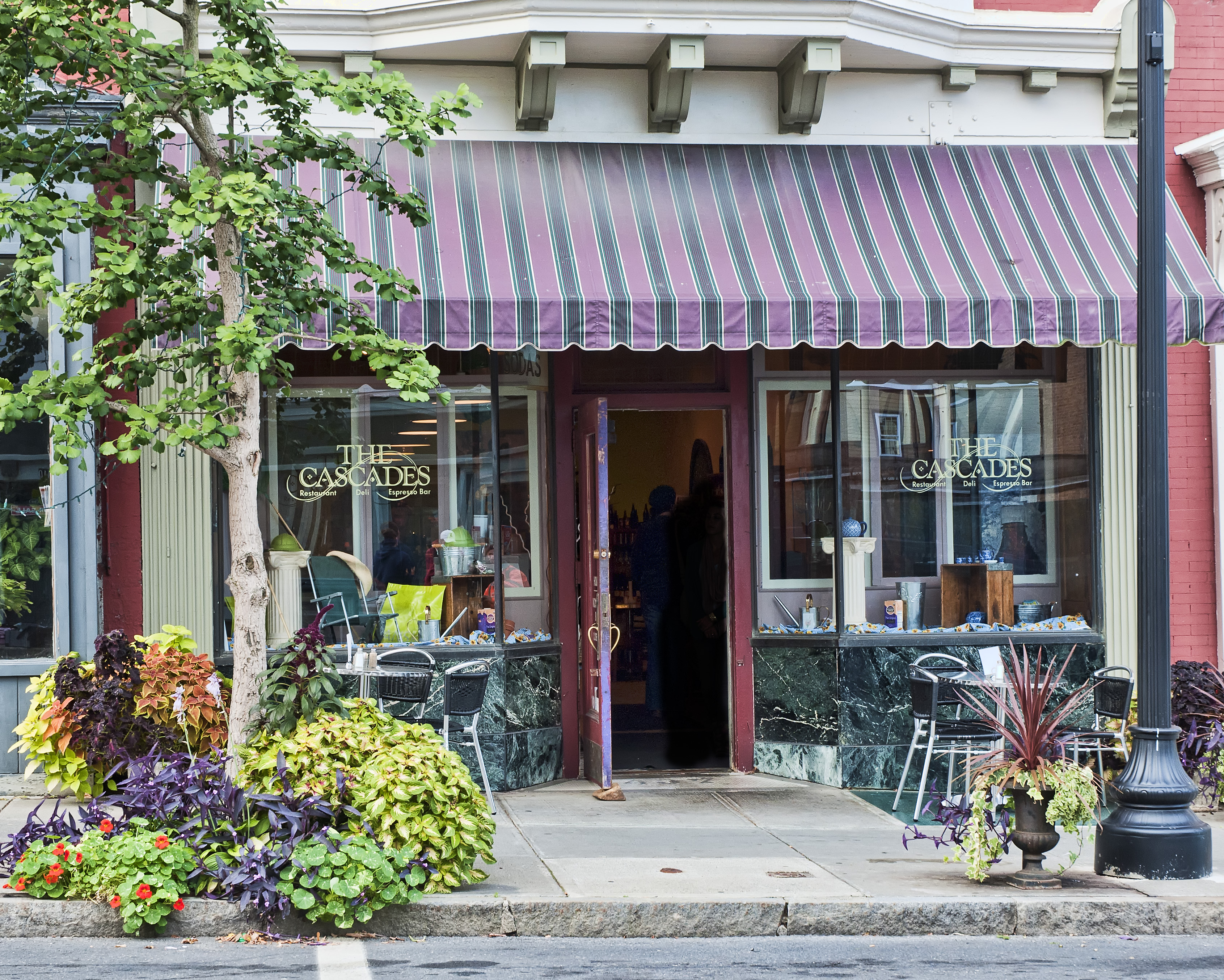
The second day of shooting of the short film The Man at the Counter (Facebook site: The Man at the Counter) took place entirely inside The Cascades Cafe on Warren Street, the main street in the town of Hudson, New York. That day being a Sunday, The Cascades was closed to the public and had been rented for the day by Brian McAllister, the film’s director. This was a make-or-break day for the cast and crew, since a majority of the film’s scenes take place inside the cafe.
Happily for me as the day’s still photographer, the ceiling of the cafe was a uniform light cream color. This favored using bounce flash off the ceiling to light my shots of the cast and crew, thereby softening the overly bright highlights, unwanted reflections and dark shadows that would typically result from the use of direct flash in such a confined area.
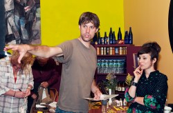
While the cafe was an ideal venue for the film, certain alterations still had to be made before shooting could start. For example, some of the furniture and equipment had to be rearranged to create a suitable open space at the counter for the scenes shot there between Ian Hyland, as the young server, and Bill McHugh, who plays his elderly customer. Since these scenes are a part of a story told in flashback by the film’s 30-something protagonist (Tom Everett Scott) about events that occurred when he was 16, the menu items and prices on the blackboards behind the counter had to be changed to those one might have expected to see about 15 years ago. These arrangements were planned and carried out by art director Kaitlyn McInnes and production designer Rachel Bird, seen in the photo below (click on any photo to see a larger version):

The next shot shows the crew in discussion about the setup of the Red One digital cinema camera and the other equipment. Shown from left to right are director Brian McAllister, director of photography Dennis Donovan, producer Bob Cammisa and assistant camera/key grip Phil Toran:

An area was set aside in the back of the cafe for costume designer Katie Maher and her wardrobe. The scenes shot in the cafe take place over a period of several days and numerous costume changes were required. In this shot, Katie assists Bill with a costume:

This photo shows Ian and Bill at the counter in a run-through of a scene before shooting began:

In this photo, director Brian McAllister discusses a scene with Ian and Bill:

Here is director Brian acting like – a director (shown with hair and makeup artist Candice Crawford):

In this photo we see screenwriter Rebecca Sue Haber and producer Bob Cammisa awaiting their turn to appear as extras, seated at the table in the cafe at which they briefly appear in the film:

After a long day of shooting, the crew had to restore the cafe to exactly its condition at the start of the day. This included erasing the menu blackboards and rewriting the original menu items and prices! It was late Sunday evening before the crew was ready to leave for the night. But it was amazing to me how much had been accomplished that day. All was set now for the scenes with Tom Everett Scott, who was scheduled to fly in from Los Angeles the following weekend to shoot the first and last scenes of the film and to record his voiceover.
You can see a larger version of any of the above photos by clicking on the photo. Additional photos can be viewed at my photography website in the gallery The Man at the Counter. For additional information about my photography, please also see my photography Facebook page.
Phil Haber
Copyright © 2011 Philip A. Haber
